II. Task I. Navigation and Cross-Country Flight Planning
⚠️ Disclaimer: This is for educational purposes only. I am not a certified flight instructor (CFI)... yet. (Working hard on it!) Until then, please don't use this as a substitute for professional flight training. Always consult a real CFI and follow your aircraft's POH. I accept no liability for any actions taken based on this content.
No slide deck for this lesson. It is taught on YB NAVLOG, building a real navigation log with the student.
1. Lesson Objective
- The student can plan a VFR cross-country flight from route selection to a completed navigation log and a filed VFR flight plan.
- The student understands how planned values compare with actual results in flight, and how to correct, divert, or recover when lost.
- The student can identify and manage the risks of a cross-country flight, including fuel planning and the limits of ATC services.
2. Content
- Route planning: airspace classes and special use airspace (SUA) along the route, checkpoints for pilotage, available navigation and communication facilities
- Altitude selection: terrain and obstacle clearance, glide distance, VFR cruising altitudes (14 CFR 91.159), winds aloft
- Plotting a course: true course, magnetic variation, distance
- Power setting selection from the POH cruise performance chart
- Calculations: true airspeed, wind correction angle, heading, groundspeed, time, climb and descent, ETA with UTC conversion
- Fuel requirements and VFR fuel reserves (14 CFR 91.151: day 30 min, night 45 min at normal cruise)
- Weather correlation for a go/no-go decision (personal minimums)
- VFR flight plan: elements, filing, activating, closing; search and rescue starts if not closed within 30 min after ETA
- Magnetic compass errors: variation, deviation, magnetic dip (acceleration and turning errors), oscillation
- Pilotage and dead reckoning, and how they are used together
- Planned vs actual: checkpoint times and fuel, groundspeed check, heading corrections
- Diversion and lost procedures (5 Cs: Climb, Communicate, Confess, Comply, Conserve)
- Inflight intercept procedures and signals (AIM 5-6-13, 5-6-14)
- Electronic flight bag (EFB) use and backups
- Chart symbols (see the Aeronautical Chart (VFR) module)
3. Schedule (about 1 hour 30 min)
| Segment | Time |
|---|---|
| Introduction (scenario trip, what a navlog is for) | 5 min |
| Route and altitude selection on the sectional chart | 15 min |
| Building the navlog on YB NAVLOG (course, wind, heading, groundspeed, time, fuel) | 30 min |
| Weather, NOTAMs, go/no-go, VFR flight plan | 15 min |
| In flight: compass errors, planned vs actual, diversion, lost, intercept | 20 min |
| Review and risk scenarios | 5 min |
4. Equipment
- Laptop or tablet with YB NAVLOG
- Current sectional chart, Chart Supplement, NOTAMs
- Plotter and E6B flight computer
- PA-28-161 POH (cruise performance, fuel, climb and descent charts)
- Weather sources (aviationweather.gov, 1800wxbrief.com) and an EFB
- Whiteboard and markers
5. Instructor’s Actions
- Give the student a scenario trip and explain what the navlog must answer before and during the flight.
- Walk through route and altitude selection on the sectional chart, pointing out airspace, SUA, terrain, and checkpoints.
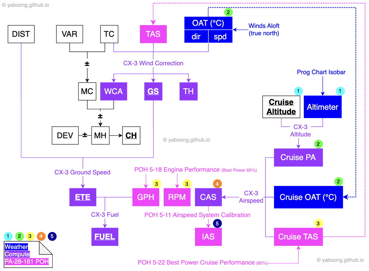
- Build the navlog together on YB NAVLOG, explaining where each input comes from and how each calculated value is derived (field relationship diagram).
- Correlate the weather briefing with the plan and lead the go/no-go decision.
- Explain VFR flight plan filing, activation, and closing, and what happens if it is not closed.
- Explain compass errors, planned vs actual corrections, diversion, lost procedures, and intercept procedures with scenarios.
- Give a fuel scenario (stronger headwind, delay, diversion) and have the student recalculate reserves.
6. Student’s Actions
- Choose the route, checkpoints, and cruising altitude, and explain the reasons.
- Complete the navlog on YB NAVLOG and check key values with the E6B.
- Brief the weather and NOTAMs and make a go/no-go decision.
- Fill in a VFR flight plan and explain how to activate and close it.
- Solve the in-flight scenarios: groundspeed check, diversion heading and time, lost procedure, intercept response.
- Recalculate fuel reserves for the given scenario.
7. Completion Standards
- The student completes an accurate navigation log for the assigned trip and explains every value in it.
- The student selects a route and altitude that account for airspace, terrain, glide distance, VFR cruising altitudes, and wind.
- The student states the 14 CFR 91.151 fuel reserves and correctly recalculates fuel for a changed scenario.
- The student explains VFR flight plan procedures, compass errors, diversion, lost, and intercept procedures, and identifies the main risks of the flight.
8. References
- 14 CFR 91.103 (preflight action), 91.151 (fuel requirements for flight in VFR conditions), 91.159 (VFR cruising altitude or flight level)
- Aeronautical Information Manual (AIM), 5-1-5 Flight Plan - VFR Flights, 5-1-14 Closing VFR/DVFR Flight Plans, 5-6-13 Interception Procedures, 5-6-14 Interception Signals
- Pilot’s Handbook of Aeronautical Knowledge (FAA-H-8083-25), Ch. 16 Navigation
- Airplane Flying Handbook (FAA-H-8083-3); Aviation Instructor’s Handbook (FAA-H-8083-9); Risk Management Handbook (FAA-H-8083-2)
- Sectional chart, Chart Supplement, NOTAMs; PA-28-161 POH
- YB NAVLOG
- Direct Isn’t Always Best: VFR Pilotage Route Planning
- Reinventing the Wheel: Why I Built a New VFR Navigation Log Format
© 2026 Yebon You. All rights reserved.
Please don't copy or reuse these materials without permission — sharing the link is welcome. Contact: yebonyou@gmail.com
