
Direct Isn't Always Best: VFR Pilotage Route Planning
Intro
It all started with one question
If I’m learning pilotage, why do I have to draw a straight line from departure to destination, like I was flying GPS direct?
TL;DR;
- On a direct route, it’s often hard to find good checkpoints for VFR pilotage.
- Planning a non-direct route is perfectly fine — even on the checkride.
- A good mental picture for a low-wing, left-seat pilot: keep the checkpoint ~2 NM off your left and scan past it along the fuel cap.
- A few extra minutes for more reliable visual references is a solid trade.
Which route is actually right?
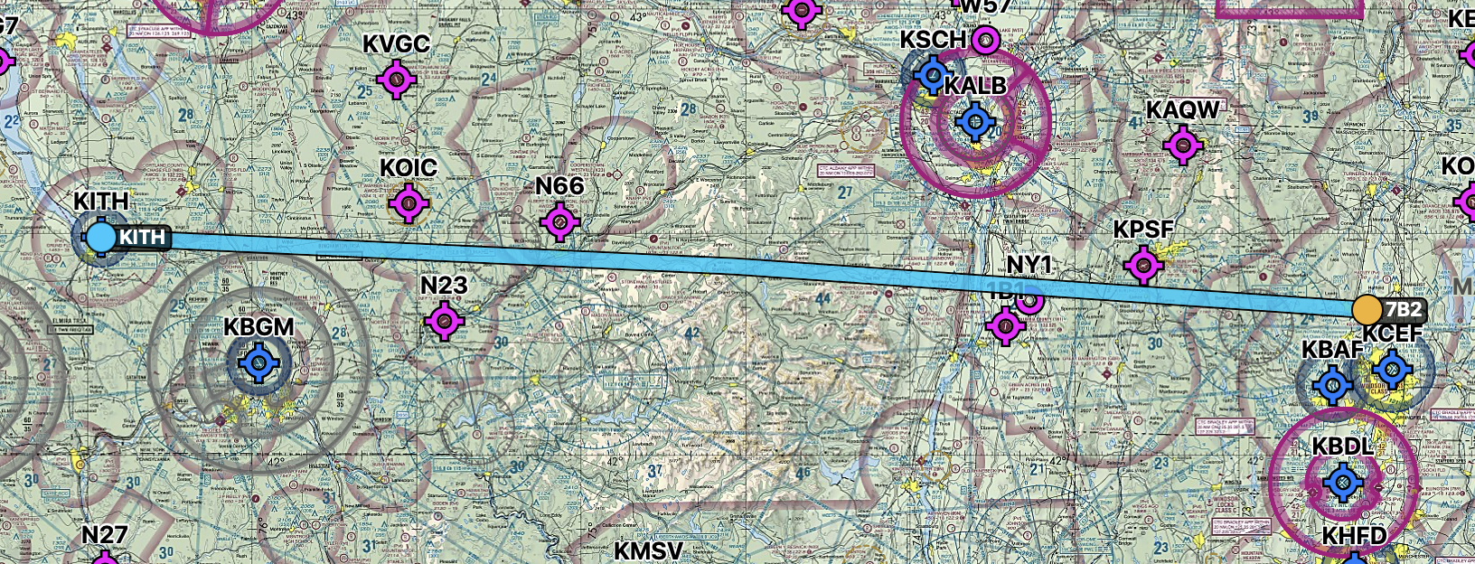
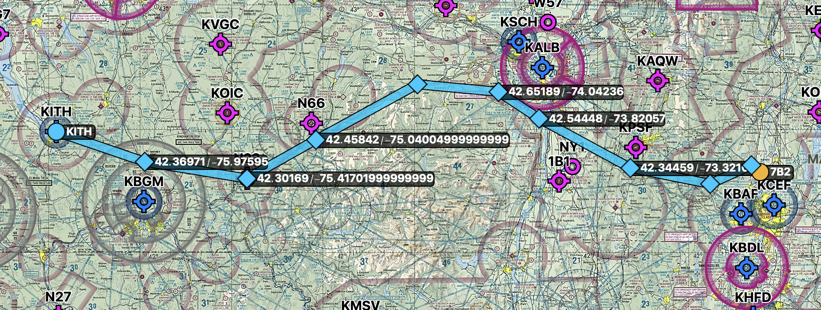
Most people’s gut answer is probably “straight, obviously.” And honestly, however you plan it, you have your own reasoning, and as long as you get to your destination safely, there’s no single right answer.
But laying a straight line from departure to destination like a GPS-direct route, then dropping checkpoints along that line and following them — that approach was, at least for me, harder.
Why was it harder? On a straight line between departure and destination, I couldn’t reliably find enough good checkpoints. So what actually makes a checkpoint “good”?
What makes a ‘good’ checkpoint?
Unique
- A feature with nothing similar nearby, so there’s no room to mistake it for something else — a single tall peak among low terrain, a lone water tower in open farmland.
- Avoid anything that’s “one of several” — one peak among many, one intersection in a grid of roads, one lake among several.
Large
- Something clearly visible at your cruise altitude and expected visibility — a city, a major river, a major highway, a ridge line. Ideally your next checkpoint should already be in sight as you pass the current one.
- Sometimes a large river is hidden behind a mountain from your vantage point, and that’s not always obvious just from looking at a chart, so it pays to double check.
Be careful using airports as checkpoints. A big field with a 5,000 ft+ runway and intersecting runways might be okay; a small ~3,000 ft single strip is hard to find — especially if it’s unpaved or blends into open or developed terrain.
An intersection
- A bridge crossing a river works well. (Road-to-road intersections are easy to confuse with each other unless the roads are genuinely major ones.)
On course, or right beside it
- A feature far from your course line makes drift hard to judge. Staying within roughly 1-3 NM of the course, on either side, is what lets you reliably tell how far off course you are. For a rough position check, up to about 5NM can still work.
A permanent feature that’s actually on the chart
- Exclude anything seasonal or temporary that might not be there when you fly. (A pond that dries up, a temporary structure, a small stream that disappears under snow.)
If checkpoints are spaced too close together, workload spikes; too far apart, and you catch a course deviation too late. Roughly 10 NM apart, or about 10 minutes at cruise speed, is a reasonable rule of thumb.
The Direct Route
Finding a “good” checkpoint at reasonable spacing, in a reasonable position, at a reasonable distance, is genuinely hard. If I could always do that, I’d just fly the straight line. But I couldn’t — and out in the actual airplane, hunting down the “well, this’ll have to do” checkpoint I’d stuck onto a straight route was even harder. That’s a big part of why navlog-based cross-country flying always frustrated me.
Don’t you not need to fly directly over the checkpoint anyway?
True — you don’t need to fly exactly over a checkpoint. In fact, in a low-wing airplane, the wing blocks your view straight down, so passing slightly to the side and looking down at an angle actually makes a checkpoint easier to identify than flying right over it. (A high-wing airplane has an open view straight down, so this isn’t as much of an issue.)
If it’s fine to pass slightly to the side, couldn’t you just keep the straight route and pick a checkpoint that happens to sit off to one side of it? That’s true too, and it works. In particular, spotting something off to your right is harder from the left seat, so I personally prefer flying so the checkpoint ends up on my left whenever I can arrange it.
So how far away can a checkpoint be?
2NM? Acceptable. 5NM? A little far. 8NM? There’s no hard line, but past about 5NM it gets hard to judge drift, and unless visibility is 10+NM you risk wandering off course before you even notice. As above, staying within roughly 1-3 NM of the course, on it or to either side, is the sweet spot.
Can’t I just use a VOR even without GPS?
Of course — a VOR is a perfectly good tool, and there’s no reason not to use it. The key is where it fits: it works best as a backup that supports your pilotage and dead reckoning, not as the primary means you lean on. After all, what we’re practicing here is VFR pilotage.
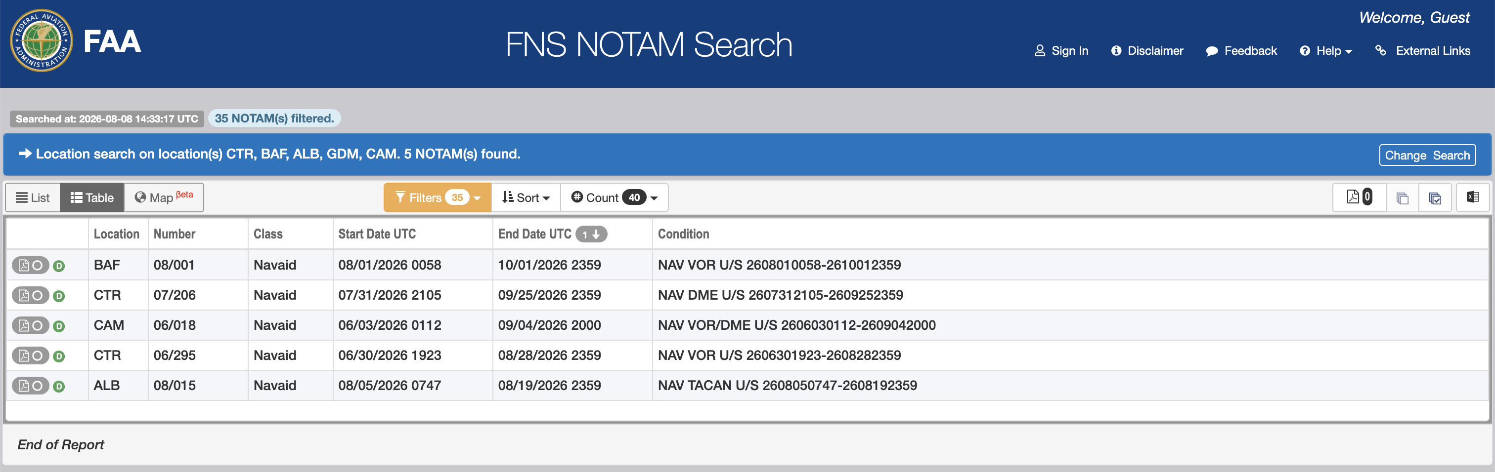
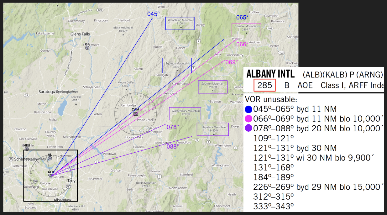
It’s also worth planning for the reality that a VOR won’t always be there when you want it. Along a given route a VOR may be NOTAM’d out of service, or the course may sit outside its usable line-of-sight range. So it makes sense to treat the VOR as one more cross-check in the toolkit, while pilotage and dead reckoning carry the flight.
VOR NOTAMs Unserviceable (U/S)
VOR (ALB) Line-of-Sight
Can’t I just use Dead Reckoning instead?
Also true. Dead Reckoning is navigation built on WCA, groundspeed, and ETE calculations to pre-plan headings and timing, and it’s just as fundamental a pillar of navigation as pilotage. It’s often introduced as a “backup for featureless terrain, open ocean or desert” but the real standard for VFR cross-country flying is the two combined: Dead Reckoning to lay out the straight course line and each leg’s heading and timing, and pilotage to verify that the planned landmark actually shows up at the planned time.
So you shouldn’t rely purely on pilotage, and you shouldn’t rely purely on Dead Reckoning either. Dead Reckoning, true to its name, is a “reckoning”, and whether you’re actually tracking that guess correctly comes down to checking it against what’s outside the window, which is pilotage. If all you bring to a checkride is a stack of Dead Reckoning calculations with no visual reference to confirm they’re actually panning out, it’s hard to show the examiner you’re maintaining position awareness.
My method
For a low-wing PA-28-161, when the terrain sits roughly 3,000-5,000 ft below my cruise altitude, I keep the checkpoint on my left and scan past it using the fuel cap as a reference point — that naturally settles me into about 2NM of spacing, which is my preferred distance.
Keeping checkpoints on the left side of the course, at reasonable spacing, and as close to the course as possible is hard to pull off with a strictly straight route.
If I went back to my PPL days and had to build a navigation log again, knowing that a small heading change could get me a much better checkpoint, I wouldn’t insist on a perfectly straight route.
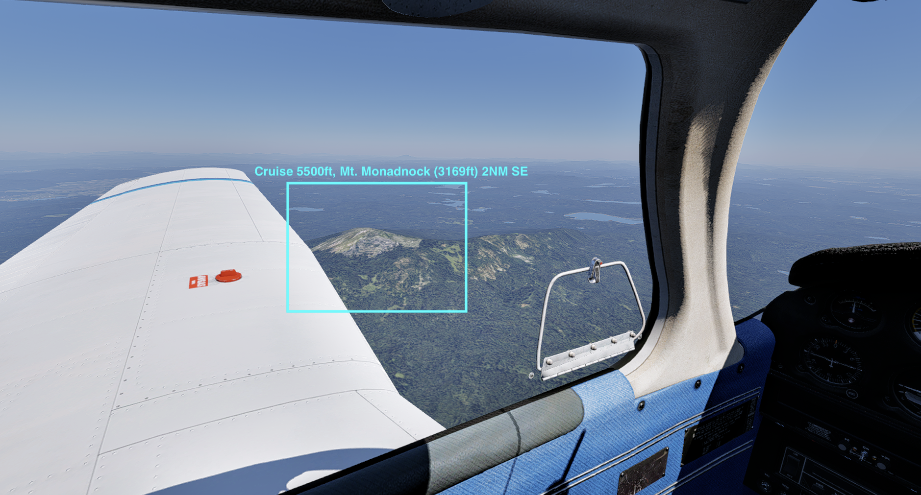
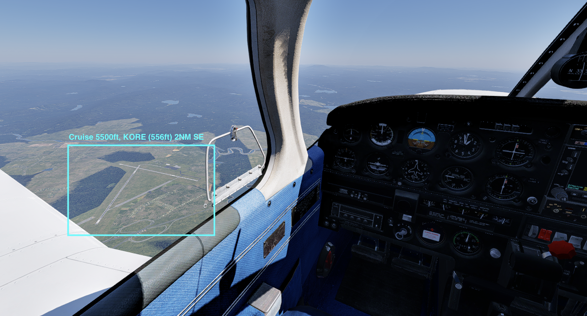
So, in conclusion
When I build a VFR pilotage navigation log, I plan a route around good checkpoints (not direct) even if it costs me a slight heading change, instead of insisting on a straight line.
The actual scenario I drew on my Commercial checkride was 7B2 to KITH. Because of the mountainous terrain, I decided a straight-line route wouldn’t let me place good, identifiable checkpoints at reasonable intervals. So instead of flying direct, I planned the route below, flew it on the checkride, and passed without any issues.
While prepping for the checkride, flying direct meant adding my personal minimum to the MEF (Maximum Elevation Figure) over the mountainous section and still meeting VFR cruise altitude requirements, which came out to 6,500 ft. Planning around checkpoints instead let me stay at 4,500 ft.
Here’s part of the material I actually brought to the checkride:

The distance difference was 14NM, but with a tailwind that day, it only cost me 4 minutes of ETE and 1 gallon of fuel. In the end, I bought a much more solid set of visual references for the price of 4 minutes and 1 gallon — and I still think that was a solid call.
Comparing the two routes in ForeFlight against today’s weather, the distance is still 14NM longer, but the fuel comes out identical and the ETE differs by only 6 minutes.
Direct: 171NM / 15gal / 1hr 54min
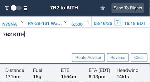
Not-Direct route: 185NM / 15gal / 2hr 00min
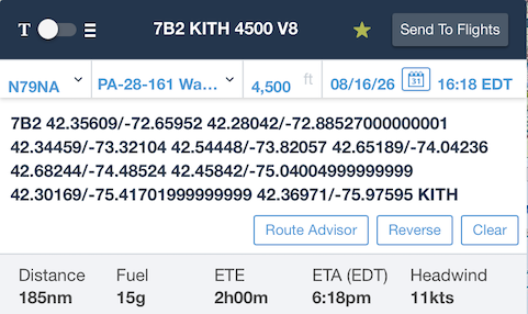
Not-Direct route I used
7B2 42.35609/-72.65952 42.28042/-72.88527000000001 42.34459/-73.32104 42.54448/-73.82057 42.65189/-74.04236 42.68244/-74.48524 42.45842/-75.04004999999999 42.30169/-75.41701999999999 42.36971/-75.97595 KITH
Disclaimer
⚠️ This is for educational purposes only. I am not a certified flight instructor (CFI). Do not use this as a substitute for professional flight training. Always consult a CFI and follow your aircraft’s POH. I accept no liability for any actions taken based on this content.

