Private Pilot Checkride Oral Cheat Sheet (Quick PPL review)
Intro
- This is the PPL version of my Commercial Pilot Checkride Oral Cheat Sheet and Instrument Rating Checkride Oral Cheat Sheet.
- Many topics overlap with the CPL version. Qualification and regulation are rewritten for the private pilot, and topics only in the PPL ACS (navigation, night operations) are added, following the Private Pilot ACS.
- It’s condensed into keywords for quick review, not an in-depth explanation. If you’re curious how I build these, see How I Prepare for the Checkride Oral.
- Click the image toggles to open the related figures.
⚠️ This content is for educational and informational purposes only. It does not constitute legal advice or an official FAA guideline. Always refer to the latest FAR/AIM and official regulations for actual flight operations. The author assumes no liability for errors or omissions in the content.
Qualification
- student pilot (61.83, 61.87): age 16 (airplane), read/speak/write/understand English
- student pilot limits (61.89): no passengers, no compensation/hire, no furtherance of business, no international, vis↓[day 3SM / night 5SM], no flight without visual reference to surface, comply with endorsement limits
- PPL eligibility (61.103): age 17, English, at least student pilot cert, ground training endorsement → knowledge test, flight training endorsement → practical test
- aeronautical experience (ASEL) (61.109): total 40h (20h dual + 10h solo)
- dual: 3h XC, 3h night (one XC 100NM↑ total & 10 TOL full stop), 3h instrument, 3h checkride prep within 2 cal months
- solo: 5h solo XC, one solo XC 150NM↑ total (full stop at 3 points, one leg 50NM↑), 3 TOL full stop at towered airport
- certificate: PPL (issued without expiration date)
- privilege & limit (61.113): no PIC for compensation/hire, except
- incidental to business/employment (no passengers/property for compensation/hire)
- share operating expenses (fuel, oil, airport expenditures, rental fees) → pay at least pro rata share
- charitable/nonprofit/community event flights (under 91.146)
- search & location operations (reimbursement)
- aircraft salesman (200h↑) demonstrating aircraft
- pro rata share: equal share per occupant (total cost ÷ number of occupants incl. pilot), e.g. $400 flight, pilot + 3 passengers → pilot pays ≥$100
- required docs pilot (61.3): PRIM (Pilot cert / Radio license(international) / ID-photo / Medical or BasicMed)
- requirements to act as PIC: PRIM, flight review, passenger currency (if carrying passengers), endorsements (if required), medical or BasicMed
- endorsement (61.31): complex, high-perf(200HP↑), pressurized(can fly FL250↑), tailwheel
- complex: retractable landing gear, flaps, controllable-pitch (constant-speed) props
- type rating: required for MTOW>12,500 lbs, turbojet-powered
- logging flight time: only required for [Cert/Rating/Flight-review/recent flight experience(61.57)]→CFR
- flight review (61.56): 24 cal months for PIC, 1hr flight & 1hr ground & endorsement
- flight review exemption: practical test (new cert/rating), FAA WINGS program
- passenger currency (61.57): 3 TOL 90days in same category/class (+type if required), full stop for night or tailwheel
- night (log): [end of evening ~ beginning morning] civil twilight
- night (currency): 1hr after sunset to 1hr before sunrise
- night (lights): sunset to sunrise (position lights)
- currency vs proficiency: minimum legal requirement vs. ability to safely operate aircraft
- unfamiliar aircraft/avionics: [glass cockpit, new GPS, new airframe]→workload↑→task saturation→situational awareness↓→[deviation, loss of control, errors, airspace violations]
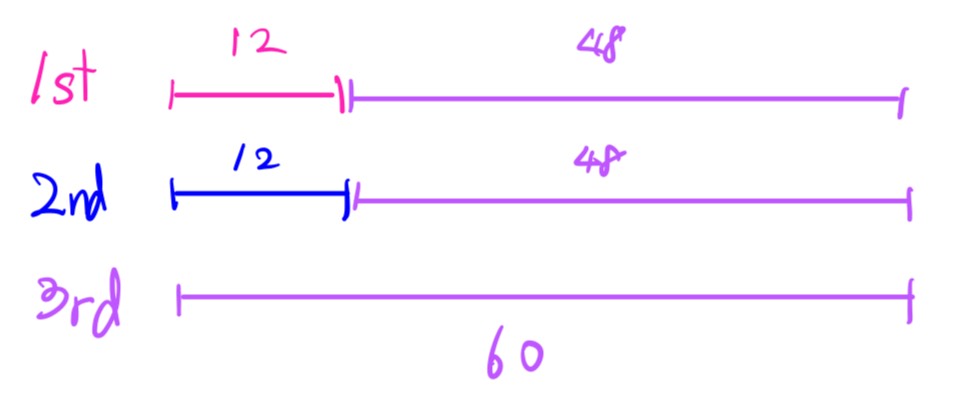
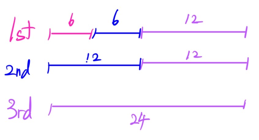
- medical (61.23): PPL → 3rd↑ or BasicMed, 3rd class [under 40: 60 cal months, 40↑: 24 cal months]
- temporary disqualification (61.53): known medical deficiency or meds that make you unable to meet the medical standards → don’t act as PIC (IMSAFE)
-
image: Under 40
-
image: Over 40
- BasicMed: alternative 3rd med, bypass AME→regular physician
- requires: 48CMEC, 24online, treatment, US driver’s, FAA med cert after 7/14/2006
- limit: US, max 7 occ. (6 passengers), MTOW 12500lbs↓, 18000MSL↓, 250kts↓, no compensation/hire
- docs presentation: [cert/med/log/+any] to administrator, NTSB, law enforcement officer
- other rules: address change 30days (61.60), DUI/DWI (motor vehicle action) report 60days (61.15)
Regulation
- required docs airplane: ARROW (Airworthiness cert / Registration / Radio license(international) / Operating limitations(POH/AFM, placards, markings) / Weight & balance)
- registration: valid 7 years (since 2023), must be in the aircraft
- airworthiness: owner/operator responsible for maintaining (AVIATES), PIC is responsible for determining (preflight, maintenance log check)
- airworthiness certificate: FAA issued, proves aircraft conforms to its type design and is in a condition for safe operation, never expires (required inspections), displayed at cabin/cockpit entrance, standard(white)
- special airworthiness certificate: not qualify standard airworthiness, still capable of safe flight, pink paper, experimental/restricted/light-sport
- required inspections: AVIATES
- AD: as required by each AD
- VOR check: 30 days (IFR only, 91.171)
- Inspection: annual 12 cal months, 100hr if for hire (can exceed 10hr to reach a place, deduct from next) (91.409)
- Altimeter/static: 24 cal months (IFR only, 91.411)
- Transponder: 24 cal months (91.413)
- ELT: 12 cal months, battery replace [1hr cumulative use / 50% useful life] (91.207)
- STC: as required
- airworthiness directive (AD): FAA issued docs to correct an unsafe condition, mandatory to comply, owner/operator responsible, PIC verifies airworthiness
- types of AD: standard(within specific time), emergency(prior to further flight), one-time, recurring
- supplemental type certificate (STC): FAA-approved major change to an existing Type Design. (e.g. sunvisor)
- SAIB (Special Airworthiness Information Bulletins): FAA-issued, non-regulatory info/recommendation (doesn’t meet AD criteria), not legally required, but highly recommended (manufacturer’s version = Service Bulletin)
- special flight permit: aka ferry permit, not airworthy but safe to fly to repair location, via AWC tool or FSDO (FSDO will require A&P letter)
- preventive maintenance (43.3(g)): pilot certificate holder, owned/operated aircraft(no part121/129/135), does not involve complex assembly operations
- log→[description, date, name, signature, certificate number, kind of certificate]
- e.g.→[Appendix-A-to-Part-43(c), landing gear tires, lights, bulbs, hydraulic fluid, …]
- maintenance type: major, alteration, repair, preventive
- preflight (91.103): NWKRAFT (NOTAMs / Weather / Known ATC delays / Runway lengths / Alternates / Fuel / Takeoff & landing performance)
- required equipments (91.205): ATOMATOFLAMES(VFR-day), FLAPS(VFR-night), for [hire/water/↑glide]→device[flotation & pyrotechnic signal 1]
- FLAPS: fuses/Landing light (only if for hire)/Anti-collision/Position lights/Source of electricity → landing light NOT required at night unless operated for hire (91.205(c)(4))
- inoperative (91.213(d)): no MEL?
- not in [VFR-day type certification(POH/AFM)→KOEL(POH/AFM)→91.205→AD]?→ then ok
- but, [remove/deactivate/placard “INOPERATIVE”] & record maintenance record, PIC determines no hazard
- MEL: minimum equipments requirement for safe flight with inoperative equipment (approved by FAA, LOA), with MEL → follow MEL
- KOEL: Kinds of Operation Equipment List (POH/AFM), which equipment required for [day/night/VFR/IFR]
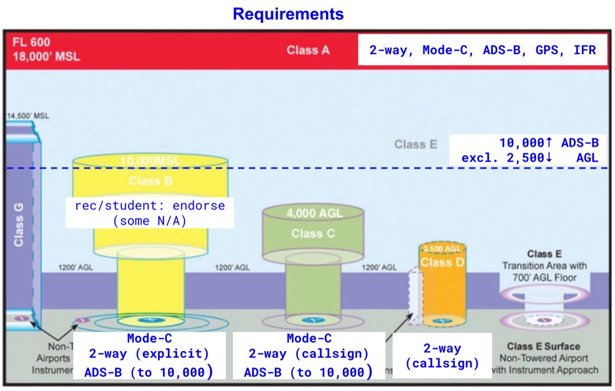
- ADS-B: class[A/B/C], B→30NM, B/C→10000MSL↓, E→10000MSL↑(no 2500AGL↓)
- mode-c xponder: altitude reporting, class[A/B/C], 10000MSL↑(no 2500AGL↓)
- minimum safe altitude (91.119): anywhere[power fail→safe land], congested[↔2000,highest+1000↑], other-than-congested[500↑AGL], sparsely populated or water[no-limit but 500ft distance away from any person/property]
- VFR cruising altitude (91.159): 3000AGL↑, magnetic course 0~179(odd thousand+500), 180~359(even thousand+500)
- fuel requirement (91.151): (normal cruising speed) VFR-day[+30’], VFR-night[+45’]
- safety belts (91.105, 91.107): crew[cruise:belt,TOL:+harness], passenger[cruise:x,TOL:belt], exception[2yrs-old↓,parachuting], PIC briefing (how to fasten/unfasten)
- alcohol & drug (91.17): [4,8,16], 0.04<↓, no within 8hrs, 1oz→3hrs, can remain 16hrs, no intoxicated passengers (except emergency/medical care)
- supplemental oxygen (91.211): unpressurized?→12500<(min-crew,30min+)≤14000, 14000>min-crew, 15000>occupant provided
- right-of-way (91.113): distress > BGTS > engine, head-on→both turn right, converging→aircraft on the right, being overtaken has right-of-way (overtake on the right), landing→lower altitude (don’t cut in)
- speed limit (91.117): 10000MSL↓→250kts↓, under class B or VFR corridor 200kts↓, within 4NM of class C/D primary & 2500AGL↓ → 200kts↓
- SVFR (91.157): below VFR [ceiling<1000, vis<3] but [CoC, vis≥1] unless NO-SVFR, surface area of controlled airspace below 10000MSL → ATC clearance, night → IR & IFR-equipped
- aerobatic flight (91.303): NO[congested-area/open-assembly/class B,C,D,E surface area/within 4NM of airway/1500AGL↓/vis<3SM]
- parachute (91.307): passengers + bank>60° or pitch>30° (nose up/down) → parachute required (except flight training/checkride with CFI)
- dropping objects (91.15): allowed with reasonable precautions to avoid injury/damage
- NTSB (830): accident[death/serious injury/substantial damage] → notify immediately, report within 10 days (7 days if overdue aircraft), incident → immediate notification for listed items (e.g. flight control failure, in-flight fire, collision in flight)
- PA28 class & category: aircraft[category:normal/class:airplane], airmen[category:airplane/class:SEL]
- aircraft’s $CLASS == airmen’s $CATEGORY($CLASS)
-
image: aircraft’s $CLASS == airmen’s $CATEGORY($CLASS)
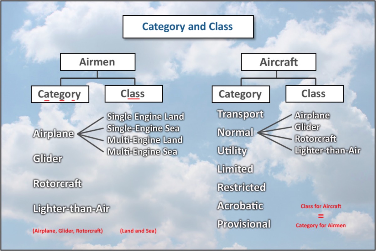
- airplane (ASEL/ASES/AMEL/AMES)
- rotorcraft (helicopter/gyroplane)
- glider
- lighter-than-air(airship/ballon)
- weight shift control(land/sea)
- powered parachute(land/sea)
-
Systems
- PA-28-161: [FC LR HAND 160 2700], Four-cylinder, Carbureted, Lycoming engine (O-320), Reciprocating piston engine, Horizontally opposed, Air-cooled, Naturally aspirated, Direct-drive, 160HP at 2,700 RPM.
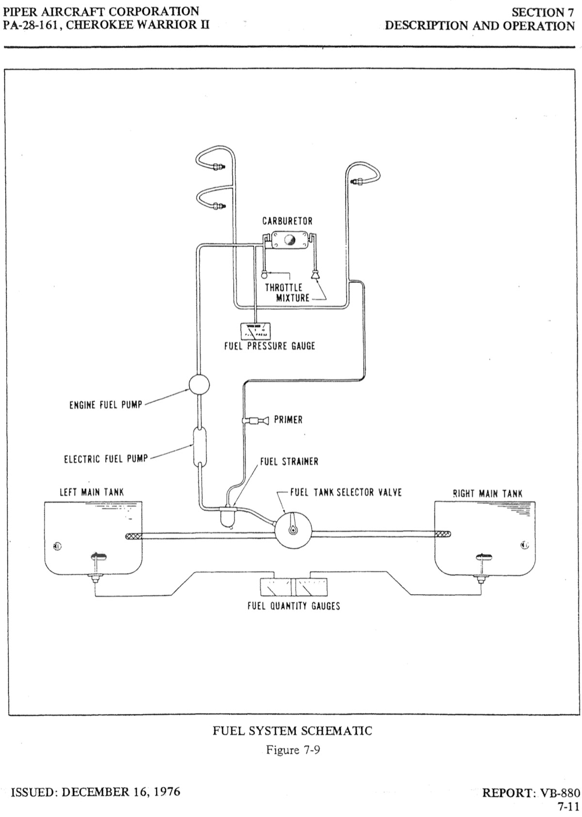
- fuel system (POH) diagram
-
image: fuel system (POH) diagram
-
- 4-stroke: intake(air/fuel mixture), compression, combustion(ignites→power), exhaust
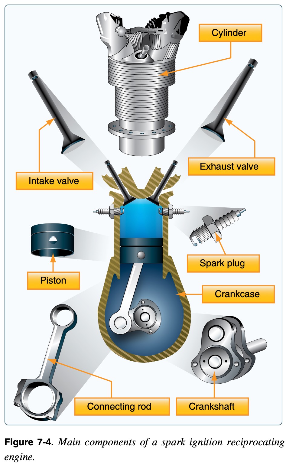
- engine components: crankcase, cylinder, piston, connecting rod, crankshaft, valves, spark plug
-
image: engine components
-
- induction system: brings air→mix with fuel→delivers mix to cylinder (4-stroke), best 14.7:1 (air:fuel), types[carburetor/fuel-injection]
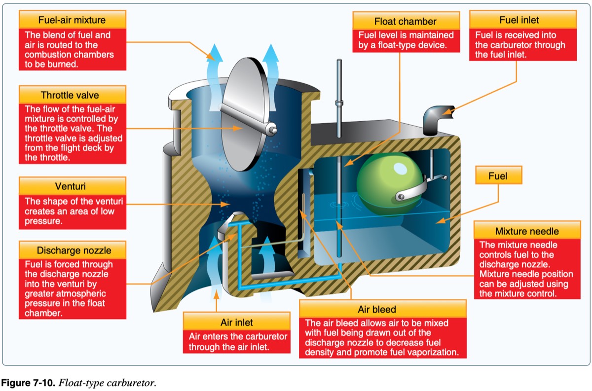
- carburetor: types of induction system
-
image: carburetor
-
- carburetor flow: air inlet → air filter → carburetor venturi (static pressure↓→fuel comes in due to pressure diff) → mix(air/fuel) → cylinder → 4-stroke
- carburetor icing: -7~21℃(20~70°F)↓&humidity80%↑, venturi→temperature↓→ice→airflow↓→RPM↓
- temperature↓ caused by: fuel vaporization, low power means cools↑ & venturi↑
- carb heat: heat exchanger(near exhaust manifold) provides hot air → anti-icing, but RPM↓(hot→density↓→air↓→rich→RPM↓)
- fuel-injection: fuel is injected directly into the cylinders
- pros: easier cold weather start, fuel flow/distribution↑, throttle response↑, precise mixture control
- cons: difficult hot weather start, vapor locks(fuel vaporize inside fuel line)
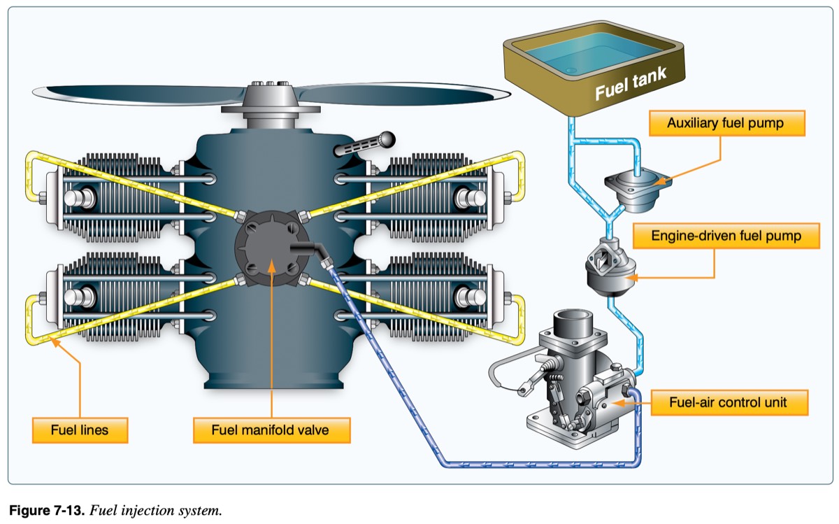
- fuel-injection flow: tank→aux fuel pump→engine-driven fuel pump→fuel-air control unit→fuel manifold valve→fuel lines with injectors
- fuel pump: pumps fuel from fuel tank into the fuel-air control unit
- fuel-air control unit: regulates the specific amount of fuel needed (based on the mixture/throttle settings), then the fuel gets sent to the fuel manifold valve
- fuel manifold valve (distributer, a.k.a spider): split metered liquid fuel evenly to injection lines (splitting)
- fuel lines (has fuel-injector): inject fuel to cylinder (spraying)
-
image: fuel lines (has fuel-injector)
-
- throttle control: controls air/fuel mixture, rapid increase→detuning engine crankshaft counterweights
- mixture control: controls air/fuel ratio, altitude↑→air density↓, but fuel density same→lean (3000ft↑), too lean→engine temp↑, too rich→spark plug fouling→power↓
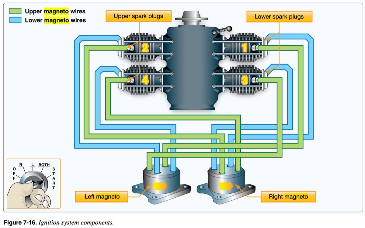
- ignition systems: independent of electrical system (but, requires battery to start)
- ignition switch on: disconnect p-lead→battery runs starter motor→crank shaft rotate→magneto rotate→generate electricity→spark plug generates spark→combustion
- ignition switch off: grounded by ground wire(p-lead)→block electricity →no electricity no combustion
- each cylinder → 2 spark plug (redundancy&better ignition) ignite air/fuel mixture
- each spark plug → connected to different(L/R) magneto (redundancy)
- magneto: permanent magnet, engine-driven (crankshaft) → generates its own current, ignition switch only grounds(off)/ungrounds
-
image: magneto
-
- engine abnormalities: engine temperature↑→detonation/pre-ignition→power↓
- reduce power, rich mixture, lower nose (air cool)
- detonation: uncontrolled explosive ignition, caused by[incorrect fuel grade, too lean, too long ground ops in hot weather, high MP with low RPM]
- pre-ignition: ignites before normal ignition, caused by hot spots [carbon deposits, overheated spark plugs, cracked ceramic insulator]
- cold weather: pre-heat thickened oil
- oil system: LCCCseals lubricates, cools, cleans, corrosion↓, seals
- oil system components: sump, filter, pump, gauges
- oil extreme caution: [oil-pressure↓,oil-temp↑]→land ASAPossible
- vicious cycle[oil pressure↓ ↔ oil temp↑] → engine damage & fail
- oil temp↑→viscosity↓→leak→oil pressure↓→friction↑→heat↑→oil temp↑
- oil temp↑←[too lean, too much power, low oil, clogged cooler]
- oil pressure↓←[low oil, pump fail, weary bearing]
- engine cooling: engine temp[EGT(for lean), CHT], cool [oil/air/liquid], too long high pitch climb→engine temp↑→cruise climb
- exhaust system: burnt air/fuel mixture→exhaust, utilize heat[cabin/carb/defrost], carbon monoxide poisoning
- propeller: rotating airfoil, creates thrust, direct drive (directly connected to crankshaft), thrust←[airfoil shape, blade AoA, speed]
- blade twist: blade twist for uniform thrust, hub[speed↓ blade angle↑], tip[speed↑ blade angle↓] → AoA ~constant along the blade
- fixed pitch propeller: fixed angle, optimized (climb/cruise)
- climb: blade angle↓→AoA↓,pitch↓→smaller bite→spin fast→RPM↑,takeoff roll↓
- cruise: blade angle↑→AoA↑,pitch↑→bigger bite→spin slow→RPM↓,takeoff roll↑
- best efficiency?→only at a specific airspeed & RPM
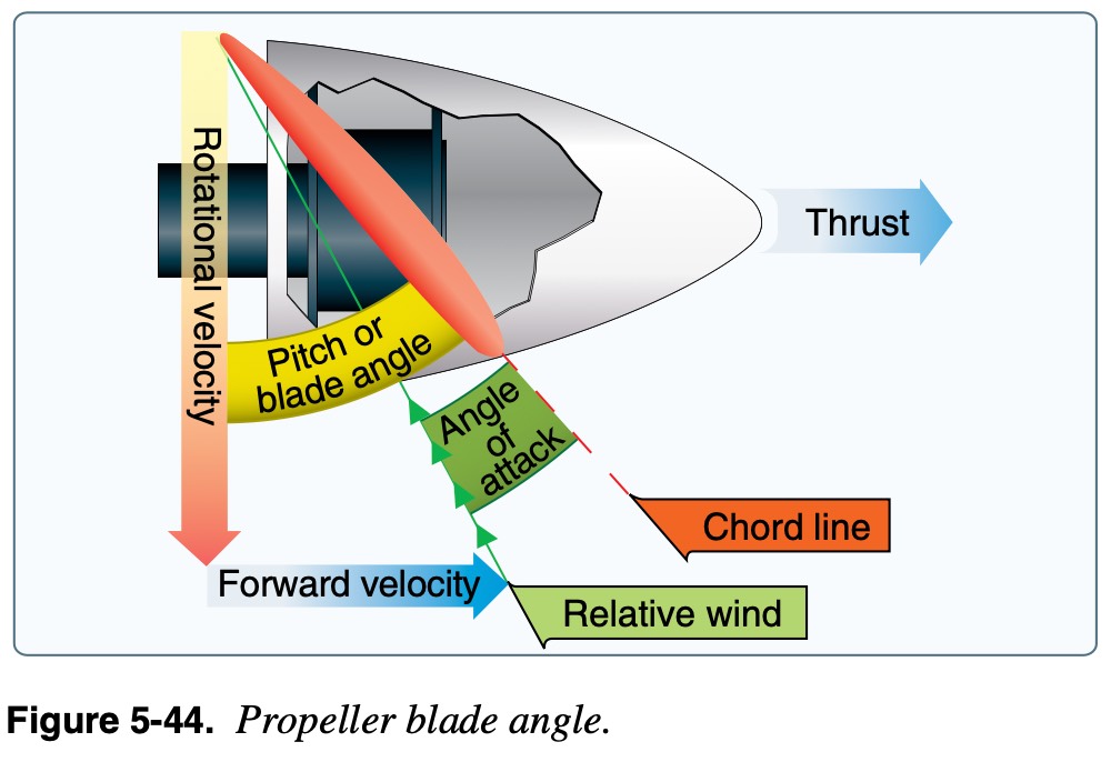
- propeller blade angle
-
image: propeller blade angle
-
- prop AoA: angle [chord line↔RW], not in motion → RW==0 → “blade angle==prop AoA”
- prop AoA = blade angle - RW angle
- optimal prop AoA: 2°~4° → depends on aircraft speed
- faster→forward velocity↑→RW angle↑(more parallel to prop)→prop AoA↓
- slower→forward velocity↓→RW angle↓(less parallel to prop)→prop AoA↑
- optimization → adjustable blade angle → “constant-speed prop” → max efficiency
- complex aircraft (FYI, not on PA-28-161): constant-speed propeller (blue lever→RPM, governor keeps RPM by changing blade angle, MP gauge→power), retractable landing gear (gear lights 3 green, gear warning horn, emergency gear extension)
- landing gear (PA-28-161): fixed tricycle gear, nose wheel steering via rudder pedals, hydraulic disc brakes (toe brakes)
- vacuum system: engine-driven vacuum pump → attitude & heading indicators, check suction gauge, vacuum fail → partial panel (turn coordinator is electric)
- electrical system (PA-28-161)
- battery (12V, 25Amp-hour): provides power to starter, backup for alternator fail (typically 30min)
- alternator (14V, 60Amp): primary power source, engine-driven, connected to crankshaft, charge battery
- ammeter: measures current flow to(charging+) or from(discharding-), (-) means alternator failure (system’s draining battery)
- loadmeter: no (-) sign, shows total load supplied by alternator, electric load↑→indicate↑, 0→alternator failure
- fuses/circuit breaker: prevents overloading, fuses→break→replace, circuit breaker→pops→fix&reset
- electrical consumers: electric fuel pump, ignition switch(starter), pitot heat, comm/nav, transponder, ADS-B, GPS, audio panel, G5, lights [landing/position(nav)/beacon/strobe/instrument-panel]
- environmental systems: maintain “cabin altitude” much lower than the actual flight altitude (typically 8,000ft or less)
- alt.↑→pressure↓→air density↓→requires[pressurized/oxygen↑]
- pressurized: airliner uses bleed air from compressor in engine, largeGA uses turbocharger/supercharger from engine → maintain inside pressure↑
- depressurization(decompression): when pressure system fails
- explosive de.: pressure change (<0.5s) is faster than lung’s equalization → potential lung damage
- rapid de.: pressure change (>0.5s) is slower than lung’s equalization, no lung damage but hypoxia↑
- oxygen system: oxygen↓→hypoxia, FAA recommends oxygen [10000ft day, 5000ft night]
- ignition source(oil/grease/even lip balm..)+oxygen → fire
- supplemental oxygen (91.211)
- heat systems: outside air flows through shroud(surrounds exhaust muffler→hot), crack in muffler?→deadly carbon monoxide poisoning (colorless, odorless)
- anti-icing/deicing: anti-icing(prevention), deicing(removal), use several times
- for airfoil: inflatable deicing boots, thermal anti-ice leading edge, weeping wings
- for windshield: alcohol anti-ice, electric heating anti-ice, defroster
- for propeller: alcohol anti-ice, electric heating anti-ice, deicing boots
- others: pitot heat, carb heat
- residual ice↑ with [airspeed↓/temperature↓]
- PA28: no de-icing, anti-icing (carbheat/pitot-heat/defroster)
- aircraft lights: landing, beacon(shows engine running, flashing red on tail), strobe(anti-collision, sparky), position/navigation (red:L, green:R, white:back)
- ELT: sends signal (in-impact/manual), emergency freq (121.5/243.0military), inspect 12 cal months, battery replace[1hr-usage/50%-life]
- FADEC: computer controls engine&props, no [magneto, carb heat, mixture, engine prime, prop pitch]→only throttle control, backup electric system required
Flight Instruments
- pitot-static: pitot tube (dynamic p), static port (ambient static p), pitot mast
- altimeter: measure altitude above specific ref (sea level, Kollsman window), after set→within 75ft airport elev, high to low → look out below, 18000↑→29.92→FL180
- altitude↑→pressure↓→aneroid wafer expands→mechanical linkage→indicate
- kollsman window↑→indicated altitude↑
- VSI: shows rate-of-climb in fpm, trend→immediate, rate→6-9sec delay after established
- diaphragm directly connected static source, chamber receives static p via calibrated leak, climb/descend→diaphragm p change instantly, chamber change slowly→pressure diff→mechanical linkage→shows rate of climb
- ASI: measures diff between impact(ram) air p (pitot tube) and ambient p (static port)
- how: dynamic p (airspeed)=impact p - static p, diaphragm receives ram air p from pitot tube [faster→expand], air p↓ as alt↑ → ASI indicate slower → to correct → apply ambient p from static port → shows dynamic p as airspeed
- pitot-static blockage
- static port: airspeed (alt↑→speed↓, correct only at blocked), altimeter(completely blocked→freeze), VSI(calibrated leak→equalize→0)
- using alternate static source → venturi effect → lower pressure
- airspeed↑, altimeter↑, VSI (momentarily climb)
- pitot tube: only ASI, use pitot-heat
- ram air inlet (x) & drain hole (o) → as if it’s parked → ASI 0 (zero)
- ram air inlet (x) & drain hole (x) → only static port → ASI like altimeter
- types of altitude: indicated(altimeter), true(actual/MSL), absolute(AGL), PA, DA
- PA: corrected for non-standard p. (18000↑→29.92→FL180),
- PA = Altitude (field elevation) + (29.92 - current altimeter setting) x 1000
- DA: PA corrected for non-standard temp (how airplane feels like)
- DA = PA + [120 x (outside air temp℃ – standard temp.for that altitude)]
- [pressure↓/humidity↑/temperature↑] → DA↑ → less dense air → performance↓
- DA↑ → [takeoff&landing roll↑, rate of climb↓, same IAS but TAS↑ on landing]
- indicated == true alt. (proper altimeter setting + standard temp), PA==true alt.(standard day)
- PA: corrected for non-standard p. (18000↑→29.92→FL180),
- high to low look out below
- pressure[high→low]: altimeter misinterprets altitude↑→pilot try level→but actually descending→fly lower than indicated (indicated↑,actual↓)
- assuming current SLP30.12 and flying at 3500ft
- as flying to low pressure area where SLP29.92 → atmosphere pressure↓
- altimeter will show altitude↑ because of the pressure↓
- pilot corrects (descend) to level at 3500ft
- end up flying at lower altitude than indicated
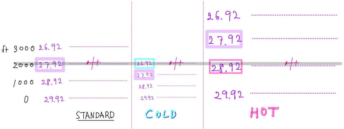
- temperature[high→low]: atmosphere contracts→pressure level contracts→same pressure exists lower(current pressure↓)→altimeter misinterprets altitude↑→pilot try level→but actually descending→fly lower than indicated (indicated↑,actual↓)
- atmosphere contracts when cold
-
image: atmosphere contracts when cold
-
- same pressure level exists at lower altitude (means pressure↓ at current level)
- altimeter will show altitude↑ because of the pressure↓
- pilot corrects (descend) to level
- end up flying at lower altitude than indicated
- atmosphere contracts when cold
- pressure[high→low]: altimeter misinterprets altitude↑→pilot try level→but actually descending→fly lower than indicated (indicated↑,actual↓)
- types of airspeed:
- IAS: indicated airspeed
- CAS: IAS corrected for installation & instrument errors←errors↑ when airspeed↓)
- TAS: CAS corrected for altitude(pressure) & non-standard temperature
- GS: TAS corrected for wind
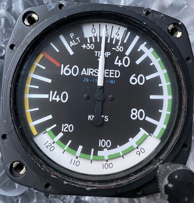
- markings: white-flaps (Vso~Vfe), green-normal (Vs1~Vno), yellow-caution, red-Vne
- gyroscopic instruments & principles: attitude indicator, heading indicator, turn indicator (vacuum or electrical)
- rigidity in space: spinning gyro remains fixed in its plane of rotation, providing stability
- precession: force is applied to gyro, resulting force occurs 90° ahead in the direction of rotation
- att ind: bank/pitch, rigidity in space, vacuum-driven or electrical, allow ~5 min after engine start to erect
- horizontally spinning gyro → non responsive to horizontal movement (yaw)
- errors: accel/decel→pitch-up/down, roll-out (after 180°)→slight opposite direction
- head ind: heading, rigidity in space, vacuum(calibrate /w mag.com) or electrical(hsi)
- vertically spinning gyro → non responsive to vertical movement (pitch/bank)
- turn ind: rate-of-turn(yaw) & rate-of-roll, precession, electrically powered
- turn coordinator: [coordination/rate-of-turn/rate-of-roll]
- turn-slip indicator: [coordination/rate-of-turn]
- mark: 3° per sec (standard rate)
- comparison (attitude, heading, turn indicator):
- attitude & heading ind. → rigidity in space, turn ind./turn coordinator → precession
- attitude indicator & heading indicator: gyro remains still, airplane moves around
- turn indicator: actual force is applied to the gyro inside
- magnetic compass err (VODM):
- variation: diff true N mag N, east least west best
- oscillation: swinging needle turb/maneuv
- deviation: aircraft mag field
- magnetic dip: earth’s mag field pulling needle down to the North (north affinity), E/W→acc/decel error(ANDS), N/S→turning err(UNOS)
- TC,MC,MH,CH: TC±variation=MC, MC±wind=MH, MH±deviation=CH
- wind → course vs heading
- variation → true vs magnetic
- deviation → compass
- EFD (electronic flight displays): LRU(line replaceable unit) collects data, PFD, MFD
- LRU (Line Replaceable Unit): modular hardware boxes that process data, easily swapped out for maintenance.
- ADC (Air Data Computer): replaces mechanical pitot-static instruments (still uses pitot/static/temp inputs), sensor processes air pressure→display(altimeter/ASI/VSI)
- AHRS (Attitude&Heading Reference System): replaces traditional vacuum-driven gryos, uses sensors&magnetometers to display att-ind./heading-ind./turn-coordinator
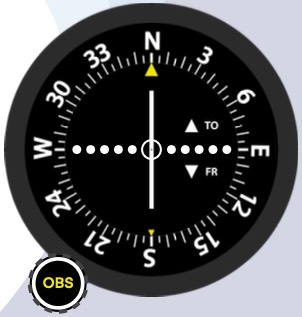
- VOR: ground station transmits 360 radials(magnetic), 108.0-117.95, (morse), OBS, CDI
- full deflection 10° (5 dots, 2° deviation for dot), 3-letter ID(verify morse)
- VOR check: VOT±4(360(0)_FROM_radial / 180_TO_course), checkpoint(ground±4/airborne±6), dual-check 4 between two, every 30 days, sensitivity (at 5th dot within 10°~12°), sign DEPS (Date / bearing Error / Place / Signature)
- VOR limit: cone of confusion (1 mile per 10,000ft), reverse sensing, require line-of-sight(unusable sector), region of ambiguity
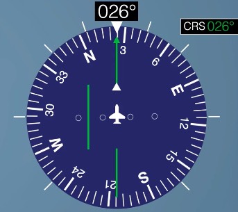
- VOR vs HSI: VOR(5 dots, 2° for each), HSI(2 dots, 5° for each)
-
image: VOR vs HSI
-
- GPS: satellite-based covers entire planet, ground control monitors, 24 satellites needed 100% operational (at least 4), RAIM
- how it works: satellite sends timecode signal → receiver calculates distance
- errors: obstacle→signal bounces→signal travel time↑, Ionosphere/troposphere delay, receiver clock errors (not atomic), GPS NOTAMs
Aerodynamics
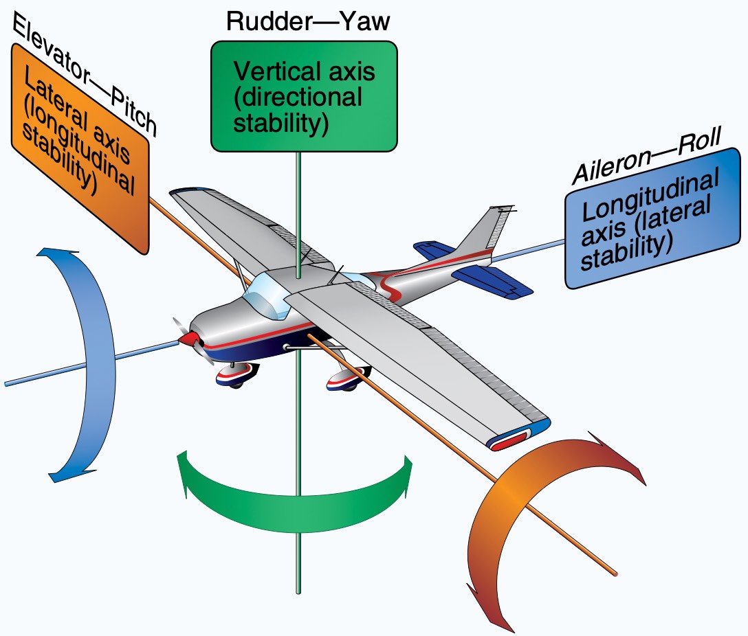
- primary flight controls: aileron, elevator, rudder
-
image: primary flight controls
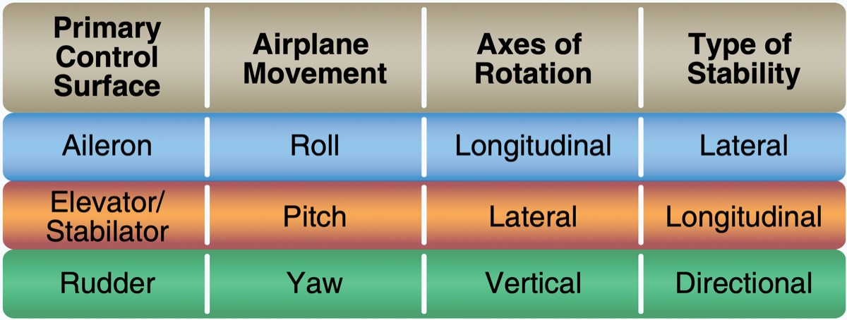
- Figure 6-4. Airplane controls, movement, axes of rotation, and type of stability.
-
image: primary flight controls
-
- adverse yaw: downward deflected aileron creates more lift & drag → creates adverse yaw → [differential aileron, frise-type aileron]
- elevator/stabilizer: moves independently → cessna
- stabilator: one-piece horizontal surface → piper
- the whole thing moves → too sensitive → anti-servo tab (also work as trim tab)
- anti-servo tab: moves in the same direction as the stabilator to provide resistance, preventing over-controlling
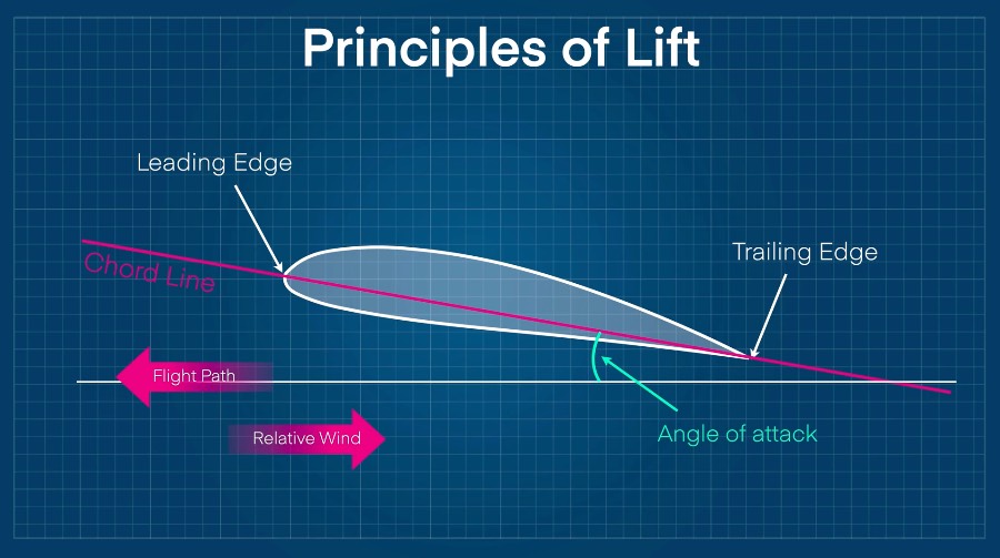
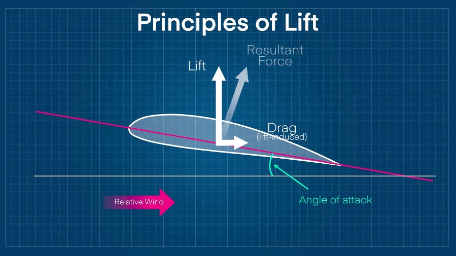
- airfoil: leading/trailing edge→chord line ↔ relative wind ⇒ AoA, AoA↑?→[cambered?→CP forward / symmetrical?→CP remains still]
-
image: airfoil
-
- secondary flight controls: flaps, leading edge devices, spoilers, trims
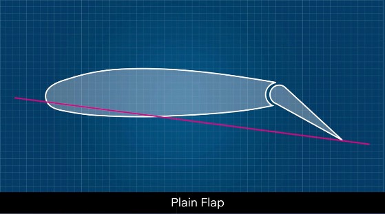
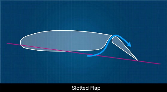
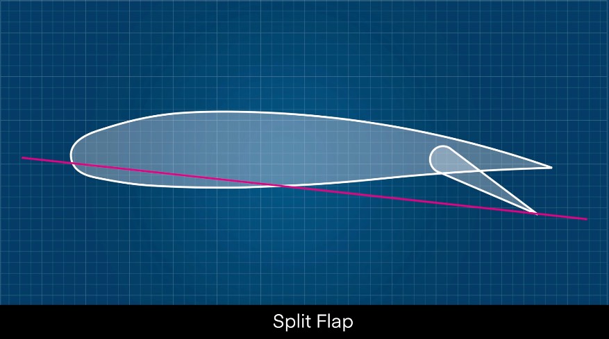
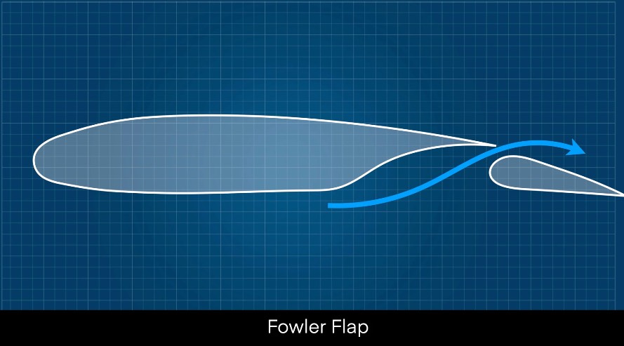
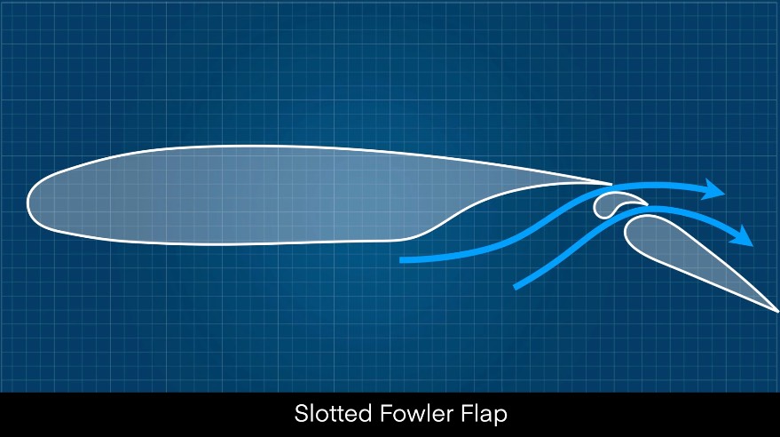
- flaps: most common high-lift devices, change airfoil shape→lift↑&drag↑ at lower speed→[steeper descent, forward visibility↑, TOL-roll↓, stall speed↓],
- flaps type: plain/split/slotted/fowler/slotted-fowler (PA28→plain)
-
image: PA-28-161
-
image: C172
-
image: flaps type
-
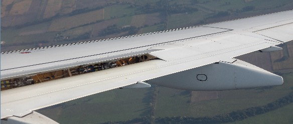
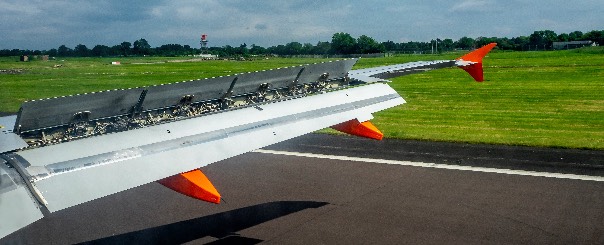
- spoilers: descent rate↑ without airspeed gain, ground spoilers(after landing)→lift↓
-
image: spoilers
-
image: ground spoilers→lift↓ upon landing
-
- 4-force: lift==weight→straight&level, thrust==drag→unaccelerated
- lift: by wing(airfoil), applied at CP/CL(center of pressure/lift), perpendicular to [relative wind, flight path], counteract weight
- weight: result of gravity, where CG applied
- thrust: by propeller(airfoil)→generate horizontal lift
- drag: opposite of thrust, parallel to [relative wind, flight path]
- lift principle:
- Newton’s 3rd law: every action→equal/opposite reaction, airfoil shape and AoA accelerate the airflow downward, wing pushes air down→air pushes wing up→lift
- Bernoulli’s principle: faster air→pressure↓, wing shape→faster air on top→lower pressure, while slow air underneath maintains high pressure, pressure diff→lift
- lift formula:
L = ½ρV²SC_L⇒ (simplified)L = V × a(AoA)ρ (rho): air density ← [altitude/temperature/humidity]↑→air↓→for same lift?→TAS↑V²: velocityC_L: coefficient of lift ← AoA (C_Lmax == critical AoA)S: wing area ← flap
- parasite drag: byproduct of flying through the air, increases with speed, airspeed↑→parasite drag↑
- proportional to the square of the airspeed: airspeed1/2→p-drag1/4, airspeed2→p-drag4
- form drag: by shape, anything sticks out, antenna, landing gear
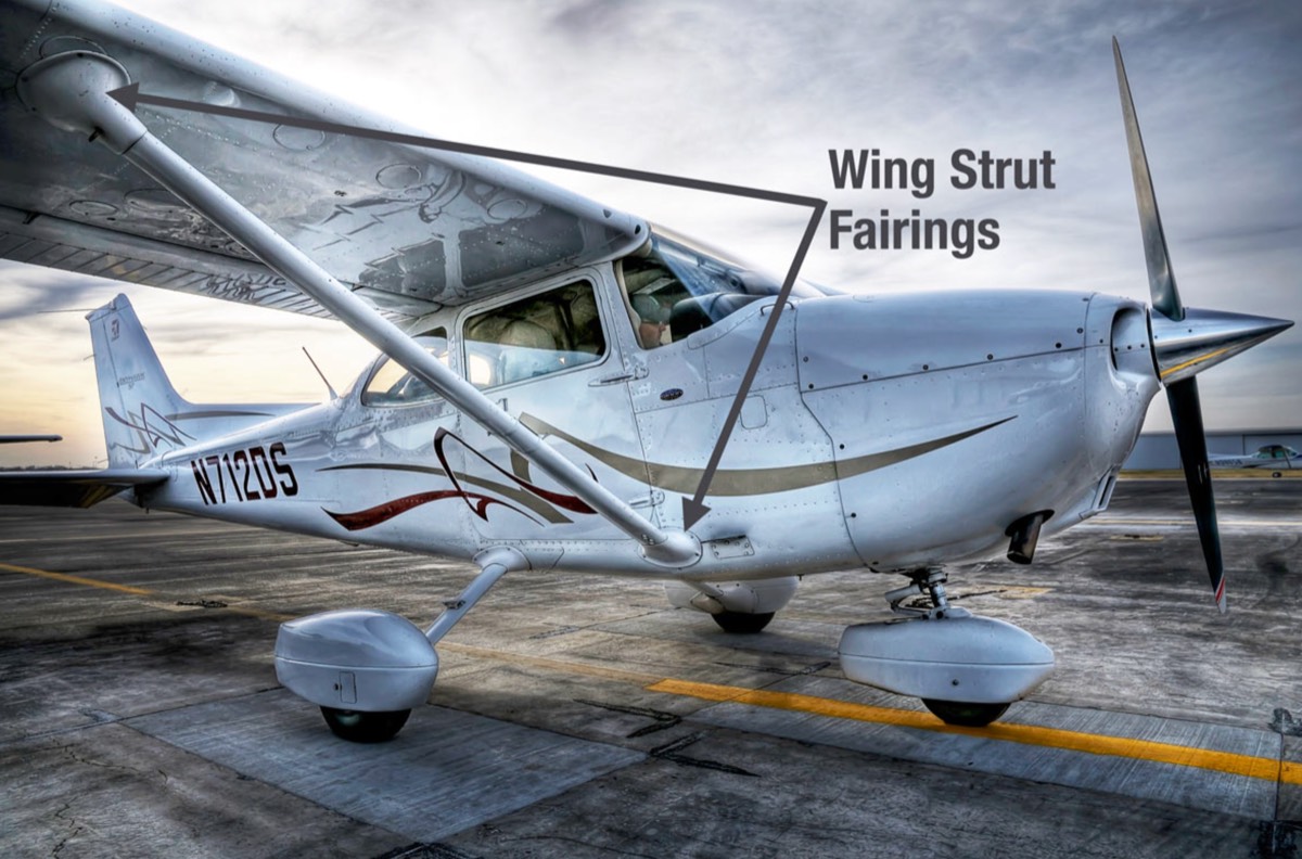
- interference drag: by intersection airstreams, this(wing)drag+that(fuselage)drag⇒even more drag(1+1>2)→fairings
-
image: interference drag
-
- skin friction drag: by rough/dirty surface (dirt, rivets)
- (lift) induced drag: “byproduct of lift, decreases with speed”
L = qSC_L(q = ½ρV²= dynamic pressure)- airspeed(V)↑→q↑→requires ↓AoA to maintain level→wingtip vortex↓→induced drag↓
- airspeed(V)↓→q↓→requires ↑AoA to maintain level→wingtip vortex↑→induced drag↑
- L/D (lift-to-drag) ratio & Vg:
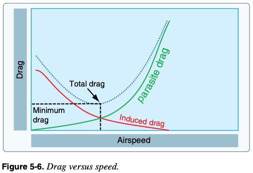
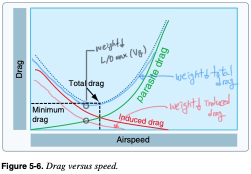
- L/Dmax == minimum total drag airspeed == Vg
- at Vg: greatest distance with least altitude lost, parasite drag & induced drag meet
- Vg changes: weight↓→required lift↓→induced drag↓→to maintain L/D max AoA(fixed)→speed↓→Vg↓
- e.g. L/D ratio=12/1→12 feet horizontal distance?→lose 1 feet vertical
-
image: original graph
-
image: weight↑→total drag↓→Vg↓
-
- AoA: “angle between chord line and relative wind”, AoA↑→lift&drag↑ up to critical AoA
- vs AoI(incidence): angle[chord line↔longitudinal axis], can’t change
- critical AoA: “max AoA” before airflow separates from wing → lift↓ rapidly, constant for a given configuration (doesn’t change with weight/bank/temp/DA/CG, flaps/contamination can change it) (varies approximately 16°~20°)
- stall: “rapid decrease in lift”, stall speed←[power/weight/load-factor]
- happens when exceeding critical AoA, regardless of [airspeed/weight/dynamic-pressure/bank/pitch]
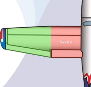
- wing root stalls first (rectangular wing, aileron→maintain lateral control)
-
image: wing root stalls first (rectangular wing, aileron→maintain l
-
- stall & stall speed & critical AoA & lift
- WE LOAD POWER (weight↑, load factor↑, power↓) → less margin to critical AoA
- critical AoA doesn’t change (same configuration), but the airspeed where the wings reach the critical AoA varies depending on [power, weight, load factor(bank/maneuver/gust)]
- stall speed↑ means: reaches stall (critical AoA) at higher airspeed (than usual)
- factors affecting stall speed: [power, weight, load factor(bank/maneuver/gust)]
L = ½ρV²SC_L⇒ (simplified)L = V × a(AoA)- power↓→[thrust&prop-wash]↓→rely more on AoA→to maintain altitude?→require AoA↑→reach critical AoA earlier→stall speed↑
- weight↑→required lift↑→require AoA↑(even at same speed)→less margin to critical AoA→reach critical AoA earlier→stall speed↑
- load factor↑(by bank↑)→vertical lift↓→tomaintain altitude?→AoA↑ or airspeed(power)↑→getting closer to critical AoA (even at high airspeed)→reach critical AoA earlier→stall speed↑(accelerated stall)
- stall recovery: [shake/buffer/mushy-control/high-pitch/engine-sound]→”reduce AoA” (AoA indicator), aft CG?→more difficult
- spin: “aggravated stall”, uncoordinated, one wing more stalled than the other
- characteristics: autorotation, nose-down corkscrew path around vertical axis, cause: stall + yaw (uncoordinated)
- most likely: engine fail during takeoff, base to final, go-around
- spin recovery: PARE(power idle, aileron neutral, opposite rudder, elevator forward)
- aft CG→more difficult, rotating around CG?→flat spin→worst
- turn: bank↑→vertical lift↓(vertical<weight)→AoA↑ to maintain level→lift↑&drag↑→[drag>thrust]→airspeed↓→add power to level
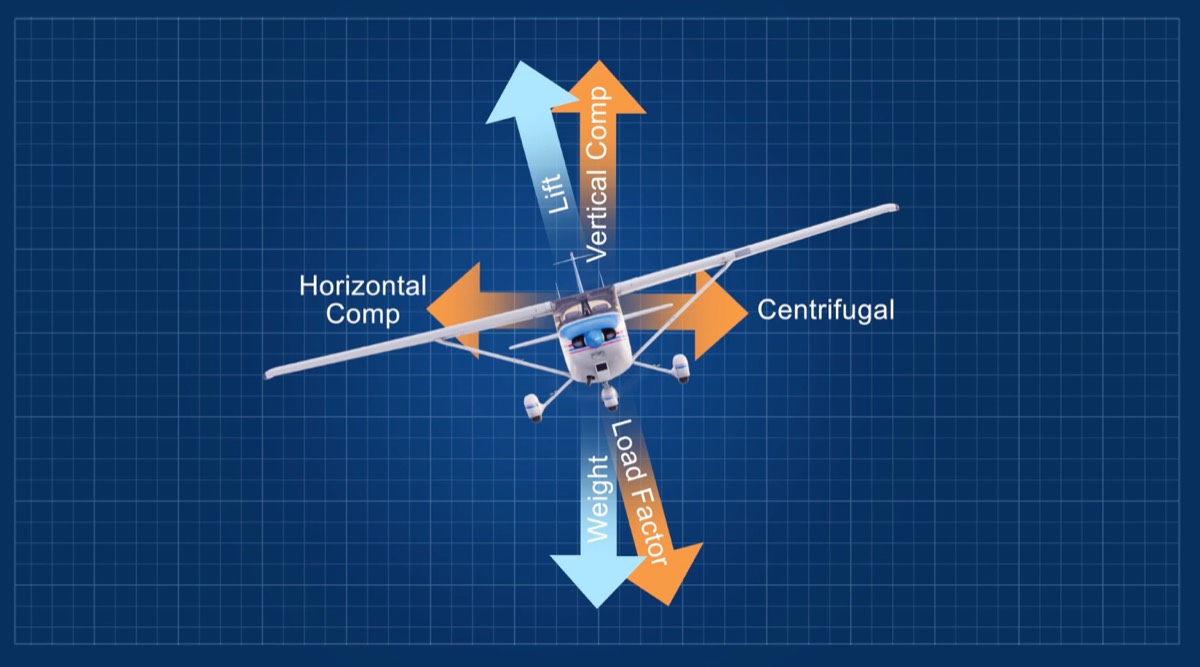
- coordinated-level turn: each opposing force is same (vertical==weight, horizontal(centripetal)==centrifugal, lift==load factor)
-
image: coordinated-level turn
-
- lift: divided into component[horizontal(centripetal)/vertical]
- horizontal(=centripetal force): actual force applied by plane when turning
- centrifugal force: feels like falling outward when turning due to inertia (not a real force)
- SWING RIDE analogy
- coordinated-level turn: each opposing force is same (vertical==weight, horizontal(centripetal)==centrifugal, lift==load factor)
- load factor: ratio of load on wing to weight (also lift-to-weight ratio=L/W), seat pressure feeling, always remains same if constant bank, bank↑→load factor↑→req.↑lift→AoA↑→stall speed↑, caused by[bank↑,rapid descent→level], coordinated 60° turn→2G, turbulence→AoA↑→load factor↑→stall speed↑⇒!reduce below Va → stalls before structural damage
- skid: too much rudder, lead to [overbanking/loss of control]
- slip: not enough rudder, efficiency↓, drag↑, loss of altitude
- rate of turn: heading change per second (standard: 3°/sec), dependent on horizontal lift(any airspeed), for constant ROT[speed(TAS)↑→bank↑], at constant airspeed[bank↑→ROT↑]
- radius of turn: inversely related to ROT, ROT↑→radius↓, at constant bank[speed(TAS)↑→radius↑], at constant airspeed[bank↑→radius↓], ground track radius→GS based
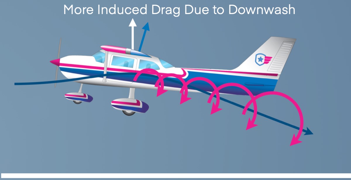
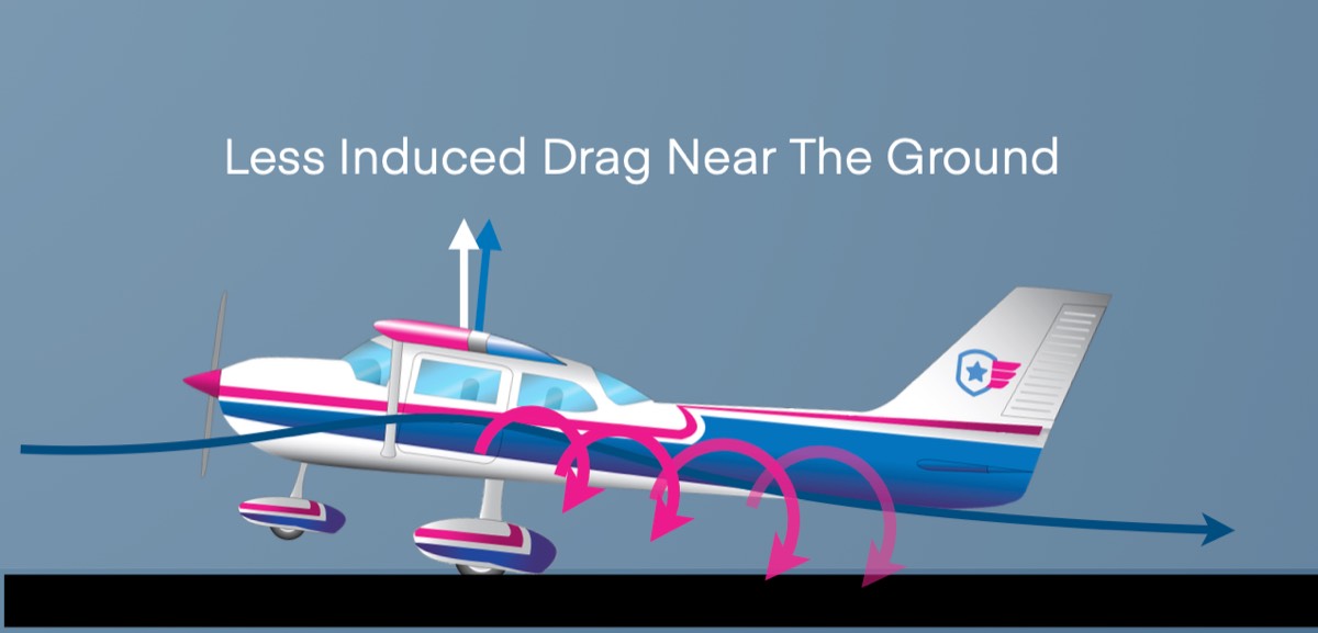
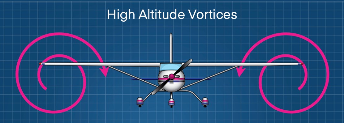
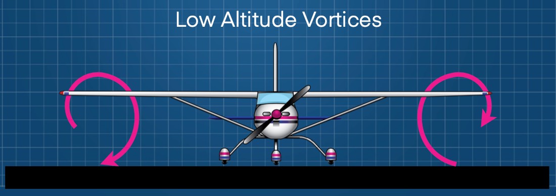
- ground effect: (ground interferes) wingtip vortices↓→induced drag↓→lift↑, starts at one wingspan (maximized closer to ground), takeoff(lift earlier), landing(float), low-wing[wing closer to ground→effect↑], leaving effect[induced drag↑→require thrust↑], into effect[induced drag↓→lift↑]
-
image: ground effect
-
- left turning tendencies: PCTG (percentage), more pronounced [airspeed↓/power↑/AoA↑]
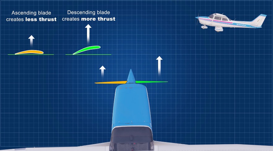
- p-factor (asymmetric loading of prop): ↑AoA→bite[downward>upward] moving blade→moves center of thrust to right→yaw left
-
image: when flying with a high AoA, the “bite” of the downward movi
-
- corkscrew effect(spiraling slipstream): spiraling air hits the left side of the vertical stabilizer, yawing the airplane left.
- torque reaction: propeller spinning right causes a left roll(Newton’s 3rd law) in the air (left yaw on the ground)
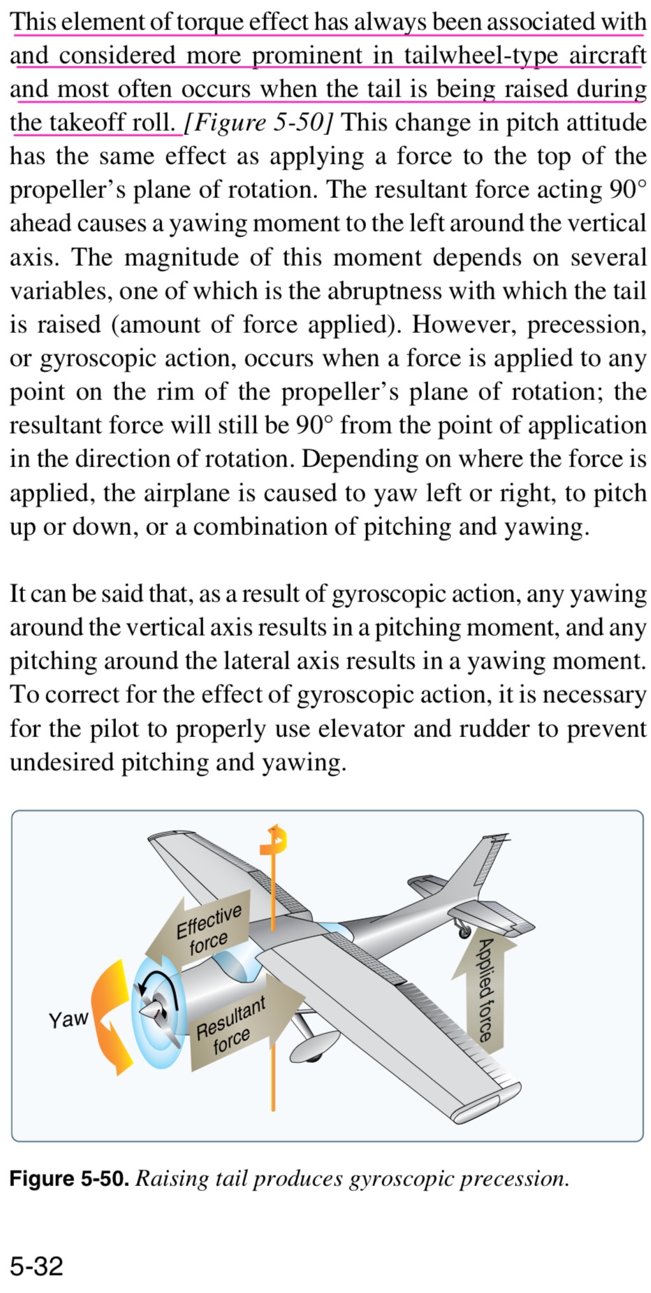
- gyroscopic action(precession): when a force is applied to a spinning object resulting force occurs 90° ahead in the direction of rotation
- PHAK 5-32) This effect is more prominent in tailwheel-type aircraft and most often occurs when the tail is being raised during the takeoff roll.
-
image: PHAK 5-32) This effect is more prominent in tailwheel-type a
-
- PHAK 5-32) This effect is more prominent in tailwheel-type aircraft and most often occurs when the tail is being raised during the takeoff roll.
- p-factor (asymmetric loading of prop): ↑AoA→bite[downward>upward] moving blade→moves center of thrust to right→yaw left
Performance & W/B
- types of altitude: indicated(from altimeter), true altitude (MSL), absolute altitude (AGL), pressure altitude, density altitude
- pressure altitude: corrected for non-standard pressures
- PA = [(29.92 - Current Pressure) * 1000] + Airport Elevation
- density altitude: pressure altitude corrected for non-standard temperatures
- DA = [(Local Temperature) - (Standard Temperature)] * 120 + PA
- airport elev=1500ft, DA=2500ft → when takeoff, airplane performs like it’s in 2500ft with standard atmosphere condition
- temperature & altitude
- pressure (default=29.92): decreases 1 inch per 1,000 ft
- temperature (default=15°C): decreases 2°C per 1,000 ft
- weight&climb: weight↑→require lift↑→induced drag↑→require thrust↑→reserved thrust for climb↓→climb performance↓
- weight&takeoff: gross weight10%↑→causes[takeoff velocity5%↑, rate of acceleration 9%↓, takeoff distance 21-22%↑(high thrust-to-weight aircraft), takeoff distance 25-30%↑(low thrust-to-weight aircraft)]
- weight&landing: gross weight10%↑→causes[landing velocity5%↑,landing distance10%↑]
- absolute ceiling: no more power for climb, only enough to level (zero rate-of-climb)
- service ceiling: altitude where unable to climb > 100fpm
- range&endurance: range[distance(NM) for consumed fuel], endurance[time(minute) for consumed fuel, min fuel?→max endurance], affected by gross weight, altitude, aerodynamic config
- factors affecting performance: better when [pressure↑/temperature↓/ humidity↓], aircraft&pilot(new/well-maintained/test pilot), airport env(rwy surface/gradient), weather(rain/snow)
- runway gradient: if 3% gradient?→±3ft elevation per 100ft
- hydroplaning: water on rwy→friction↓[tire↔ground]
- hydroplaning speed(kt) =
9 × √(tire pressure in psi)
- hydroplaning speed(kt) =
- reversed command: slow flight, short-field landing, power for altitude & pitch for airspeed
- short-field landing: POH speed, else ≤1.3 Vso, gusty → + ≤½ gust factor
- PA-28-161 ASI
-
image: PA-28-161 ASI
-
- V speeds: Vs0(44),Vs1(51),Vne(160),Vno(126),Va(88-111),Vfe(103),Vy(79),Vx(63),
- Vg(73,LDmax),Vb(87,Vs1*1.7),landingfinal(63),crosswind(17), Vlo, Vle, Vs, Vf, V1, Vmc
| type | description | PA-28-161 |
|---|---|---|
| Vs | actual, dynamic stall speed at any given moment • [aft-CG or weight↓]→Vs↓, load-factor↑→Vs↑ |
|
| Vs0 | • stall speed at landing config • bottom of White Arc. • fixed number at MW (max weight) |
44 |
| Vs1 | • stall speed at clean config • bottom of Green Arc. • fixed number at MW (max weight) |
51 |
| Vno | • maximum structural cruising speed • exceed only in smooth air (with caution) • beginning of Yellow Arc (top of Green Arc) |
126 |
| Vne | • never exceed speed • Red Line • fixed number at MW (max weight) |
160 |
| Va | • maneuvering speed • max speed for full (abrupt) control inputs without structural damage • weight↓→Va↓ (vice versa) ◦ max gross weight (2325lbs): 111 ◦ lighter weight (1531lbs): 88 • airplane stalls before breaking. / severe turbulence or rough air?→reduce airspeed to Va / allow aircraft to stall before load limits are exceeded |
88-111 |
| Vf | • design limit of flaps (for engineering) | |
| Vfe | • operational limit of flaps • max speed with flaps deployed (Vfe ≤ Vf) • top of White Arc • fixed number at MW (max weight) |
103 |
| Vy | • best rate of climb • greatest altitude gain over shortest time |
79 |
| Vx | • best angle of climb • greatest altitude gain over shortest distance |
63 |
| Vg | • best glide speed • max distance without power • changes by weight (weight↓→Vg↓) • L/D max (parasite drag & induced drag meet) |
73 |
| Vb | • turbulence penetration speed • Vs1 * 1.7 |
87 |
| turbulent air operating speed | 111 | |
| landing final approach speed (flaps 40°) | 63 | |
| max demonstrated crosswind | 17 | |
| Vlo | • maximum landing gear operating speed | |
| Vle | • maximum landing gear extended speed | |
| V1 | • maximum speed to abort takeoff • [weight↑,rwy length↓,DA↑,tailwind]? → V1↓ • once you pass V1, you can’t abort takeoff ◦ before/at V1: abort takeoff ◦ after V1: must continue takeoff (even if engine fails) |
|
| Vmc | • minimum controllable speed in a twin-engine aircraft with one inoperative engine |
- W/B terms
- W/B: total weight & location of CG, over[weight/CG]→control↓→accident, read AFM/POH
- CG (center of gravity): point where weight is applied (balance point), must remain within limit(=envelope), “Total Moment ÷ Total Weight”
- CP (center of pressure=CL): point where lift is applied (informal: “center of lift”), CG normally forward of CP
- CG range: distance between the CG limits
- datum: imaginary vertical line from which all arms are measured
- → reference point to measure arm
- arm: distance from the datum to where the weight (force) is applied
- → pilot and front seat: 80.5 → distance from the datum is 80.5 inch
- station: location of an object in relationship to the datum (similar to the arm)
- moment: weight * arm (distance from the reference point)
- SEW (standard empty weight): airplane + unusable fuel(2lbs) + operating fluids(oil)
- BEW (basic empty weight): SEW + optional equipment
- MGW (max gross weight): BEW + max useful load
- useful load: piot + passengers + cargo + usable fuel (MTOW-BEW)
- MTOW (max takeoff weight): max weight for safe takeoff
- MRW (max ramp weight): max weight on ground (including fuel before start-up←can be higher than MTOW←fuel burn during taxi)
- ZFW (zero fuel weight): BEW + payload(passengers+cargo)
- ZFW limit: structural limit to prevent wing root stress in flight
- Not for PA-28-161
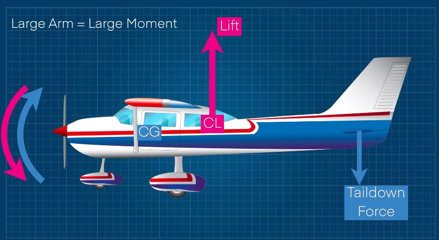
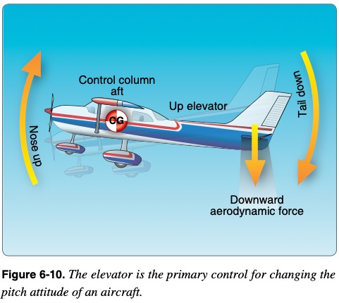
- taildown force & drag: GA aircraft → CL(center of lift) is located aft of CG
- lift generated → nose-down moment → counteract? → taildown force↑ → nose-up
-
image: lift generated → nose-down moment → counteract? → taildown f
-
- total lift (at CL) = aircraft weight + taildown force
- taildown force↑→lift↑→induced drag↑ (vice versa)
- lift generated → nose-down moment → counteract? → taildown force↑ → nose-up
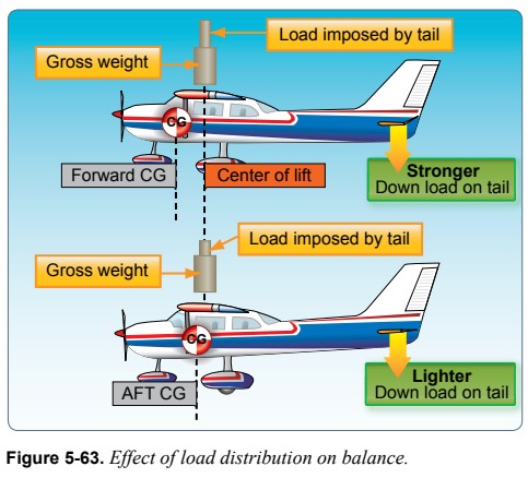
- CG: always located forward of the CL (both aft CG and forward CG)
- aft CG: CG/CL closer→nose-up→↓taildown force→wing load↓→stall speed↓
- (critical AoA is reached at a lower airspeed due to decreased wing loading)
- ↓taildown force→req lift↓→AoA↓→induced drag↓
- pros) stall speed↓,cruise speed↑,fuel efficiency↑,range↑,takeoff roll↓
- cons) stability↓,control efficiency↓(harder stall recovery),over rotation/flare on TO/L
- key) ↓stall speed, but harder to recover
- forward CG: CG/CL farther→nose-down→↑taildown force→wing load↑→stall speed↑ (critical AoA is reached at a higher airspeed due to increased wing loading)
- ↑taildown force→req lift↑→AoA↑→induced drag↑
- pros) stability↑,control efficiency↑(easier stall recovery)
- cons) stall speed↑,cruise speed↓,fuel efficiency↓,range↓,takeoff roll↑,flare difficult
- key) ↑stall speed, but easier to recover
- aft CG vs forward CG
-
image: PHAK 5-43
-
Airport
- READ: runways (PilotInstitute), signs (PilotInstitute), ILS critical (boldmethod), [AIM] Section3. Airport Marking Aids and Signs
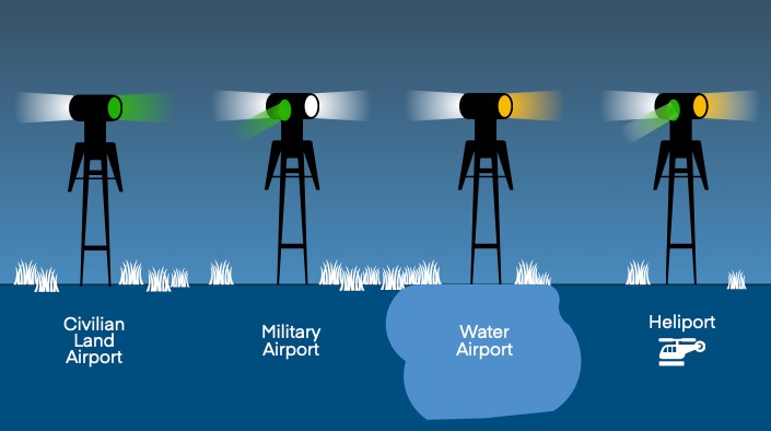
- airport beacon: active[night(ss-sr) or weather<VFR], lights[w/g(civil), w/w/g(military), w/y(water), w/g/y(heli)]
-
image: airport beacon
-
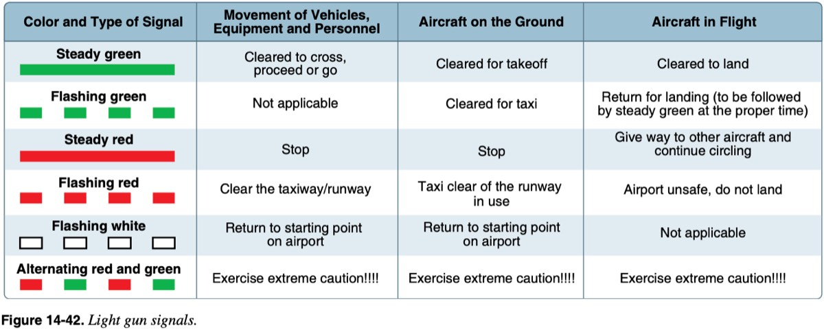
- light gun signals: in-flight[steady-G:cleared land, flashing-G:return(pattern), steady-R:circle, flashing-R: don’t land]
-
image: PHAK
-
- airport types: towered/un-towered→civil/military/private, SIDA(security identification display area)
- airport info: Chart Supplements, NOTAMs, ATIS, Aeronautical Charts
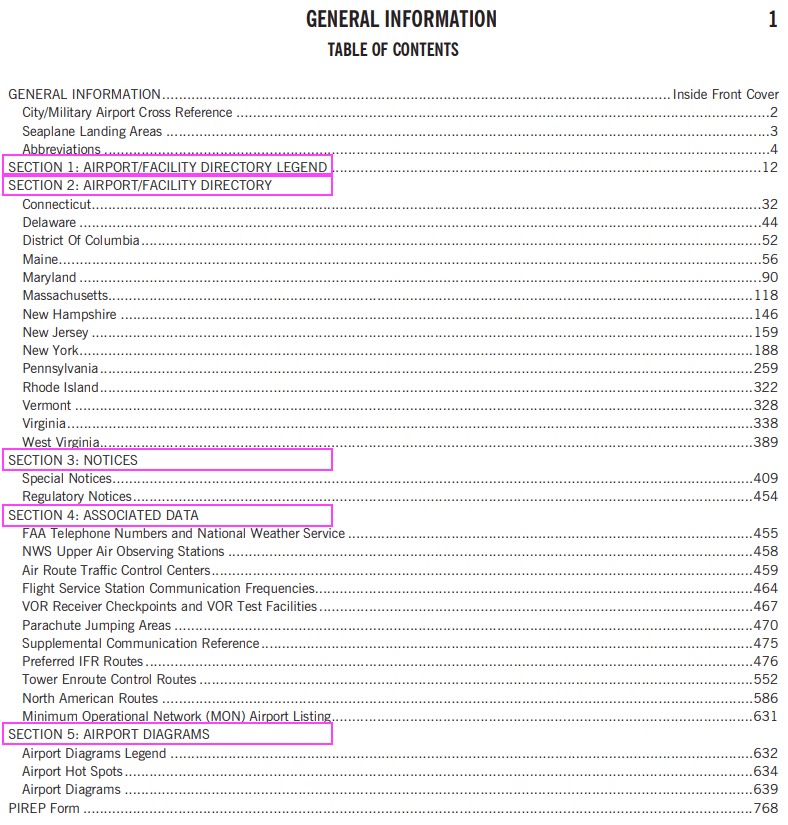
- chart supplements (CS): old AFD, 9regions, section3-major changes, section5-hotspot
-
image: chart supplements
-
- NOTAMs: critical temporary info, found(ForeFlight/FAA NOTAM search/fltplan.com), hazards[air-show/PJA/kite/rocket/drone], TFR, military exercises, obstacles, birds(BIRDTAM), volcanic ash(ASHTAM), runway conditions(0-6, for each 1/3), +ATIS
- NOTAM (D): “distant” NOTAMs, about [airports, navigation facilities, and airspace],
- e.g.[runway/taxiway closures, beacon outages, NAVAID outages, construction]
- 💡 Think of (D) as “Departure/Destination/Dirt”
- FDC NOTAM: issued by Flight Data Center (FDC), about changes in [flight procedures, regulations, airspace restrictions], e.g.[TFR, IAP amendments]
- 💡 Think of (FDC) as “Flight Document Changes”
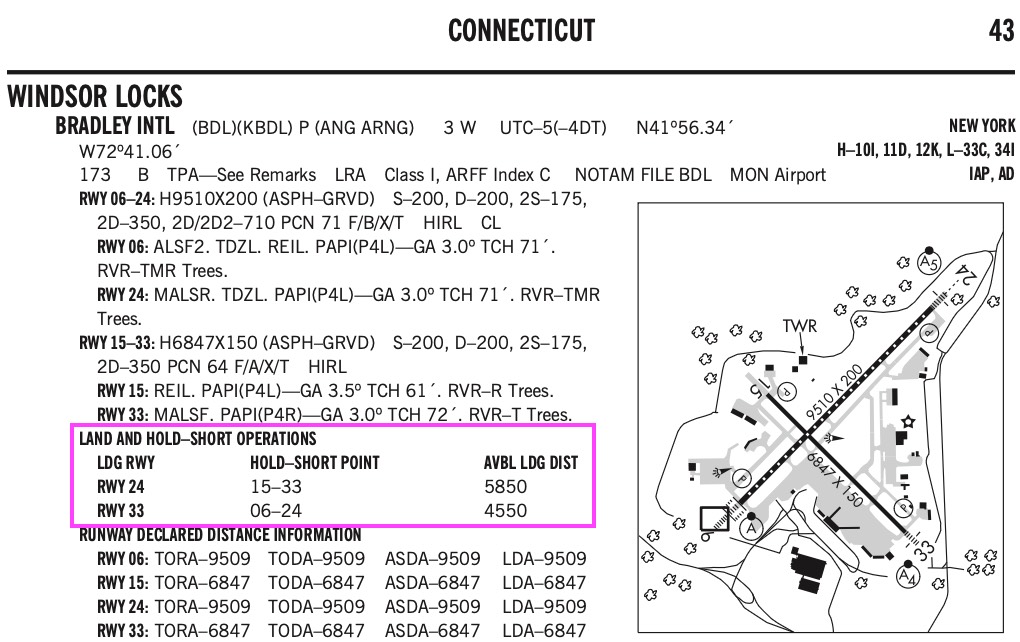
- LAHSO: TO/L intersecting rwys, pilot’s call(accept?→must comply), ceiling>1000&vis≥3SM, no student solo, within AVBL LDG DIST, available CS (or quickly ask controller LDG DIST), prohibited wet rwy surface
-
image: LAHSO
-
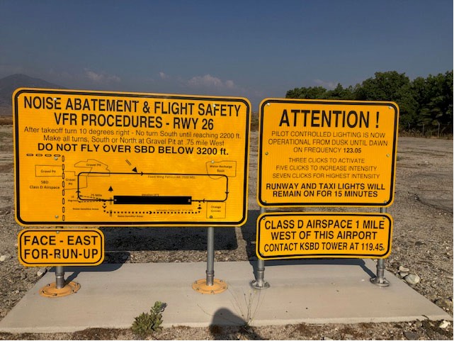
- control lighting: towered (ATC controls), non-towered [radio click in 5 sec: 7, 5, 3]
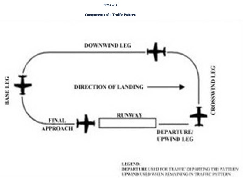
- traffic pattern: 1000ftAGL, call 10mile, entry-downwind, dep-straight/45°, non-towered(overfly 1500ftAGL→wind indicator→rwy→teardrop/midfield)
-
image: AIM FIG 4-3-1
-
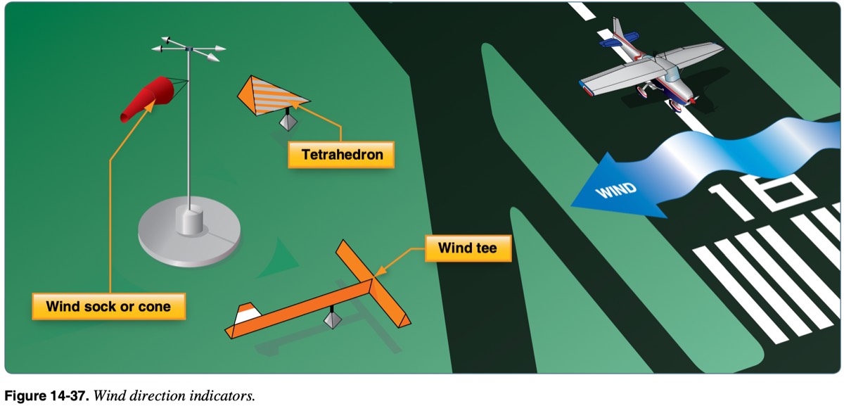
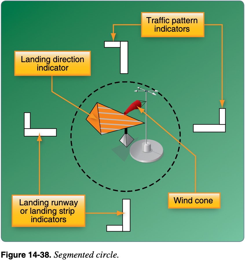
- wind direction indicators: wind sock(cone), tetrahedron, wind tee, segmented circle
-
image: wind direction indicators
-
- wake turbulence: lift creates vortices, greatest when [heavy/clean/slow], runway [rotate-before/stay-above/land-beyond], sink rate (000ft/min), affects 500-1000ft below, worst when light quatering tailwind (takeoff rwy4 after B737, wind 180@5), wingtip voritices drift at the same speed with the wind
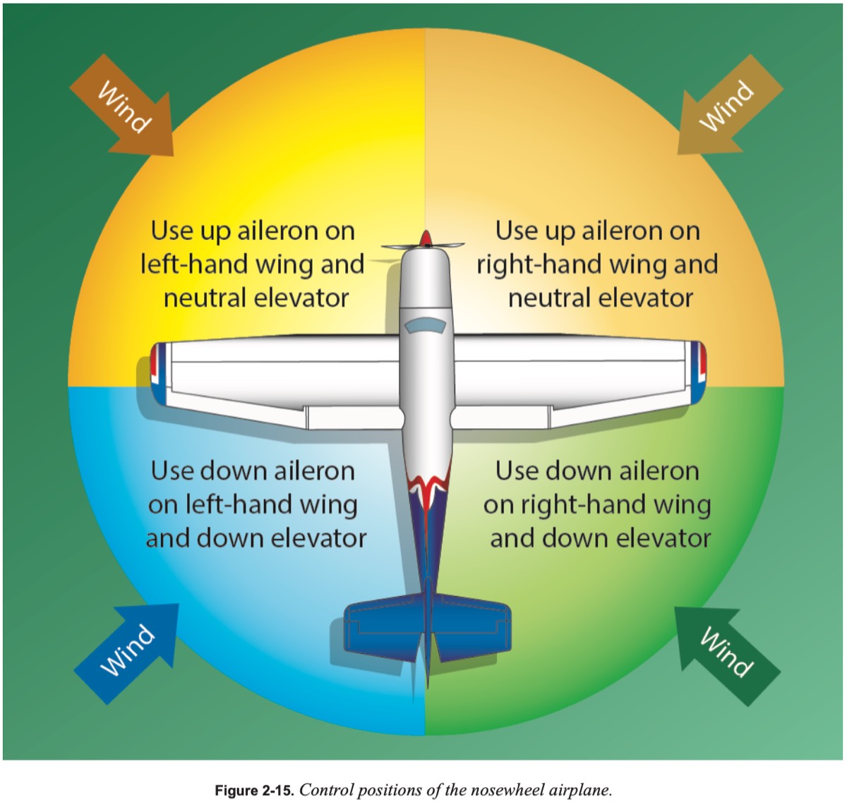
- wind correction: headwind(tricycle-into/neutral, tailwheel-into/pull), tailwind(away/push)
-
image: AFH
-
- runway: 2-digit, magnetic
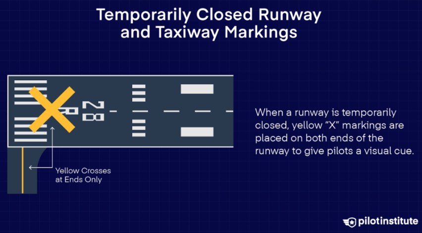
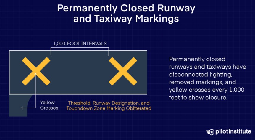
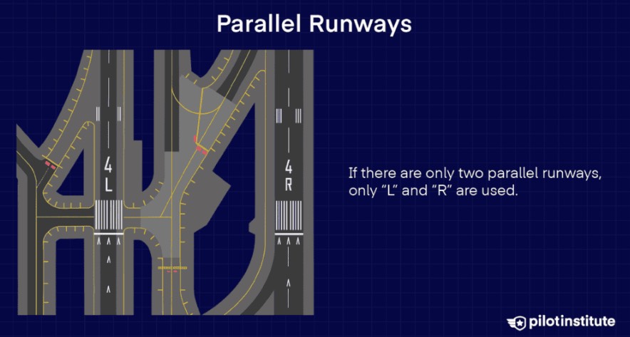
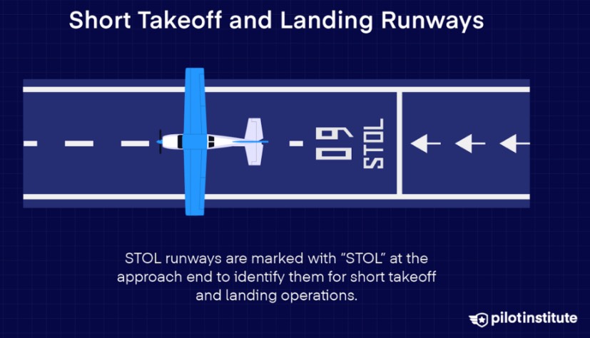
- closed[temporary(X:end), permanently(X:1000ft)], parallel runways(L/C/R), STOL
-
image: closedtemporary(X
-
- visual (no IAP), non-precision(+1 non-precision IAP), precision (+1 precision IAP)
-
image: visual (no IAP), non-precision(+1 non-precision IAP), precis
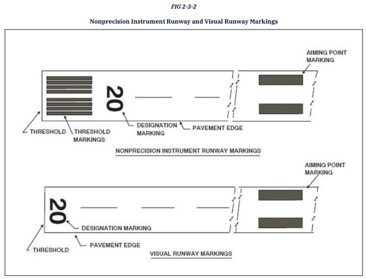
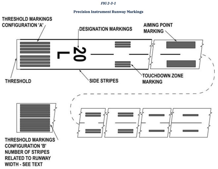
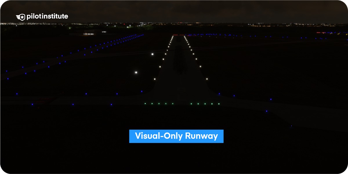
- visual rwy: no IAP
- non-precision rwy: at least 1 non-precision approach available
- precision rwy: at least 1 precision approach aid at either end of the runway
-
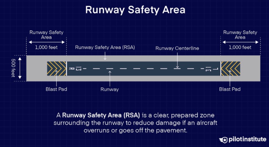
- runway safety area (RSA): buffer zone for safety
-
image: runway safety area (RSA)
-
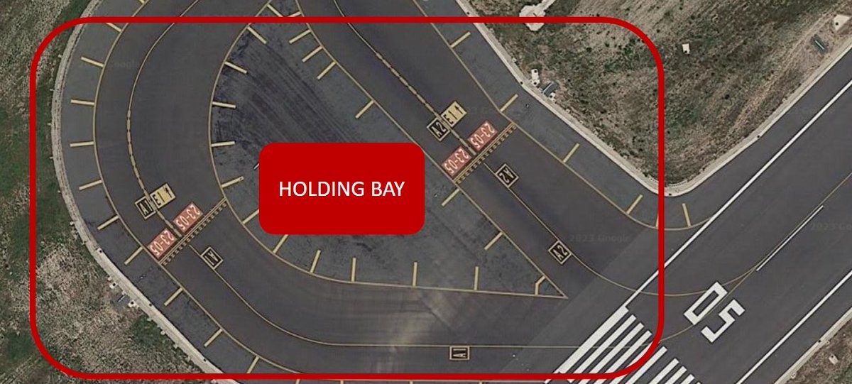
- holding bay
-
image: holding bay
-
- closed[temporary(X:end), permanently(X:1000ft)], parallel runways(L/C/R), STOL
- runway designators: aiming point, touchdown zone, threshold, displaced threshold, demarcation bar, chevrons, stopway, shoulder, centerline
-
image: runway designators
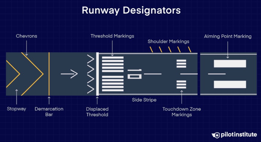
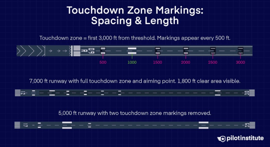
- aiming point: 2 thick white stripes, 1000ft from threshold, aligned glideslope
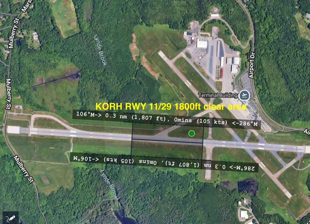
- touchdown zone: from threshold to first 3000ft every 500ft, overlaps?→1800ft clear area (possibly not exact center, by precision/non-precision)
-
image: touchdown zone
-
image: Example) KORH RWY 11/29 1800ft clear area
-
- threshold: beginng of rwy, width→[4:60ft,6:75ft,8:100ft,12:150ft,16:200ft]
-
image: threshold

-
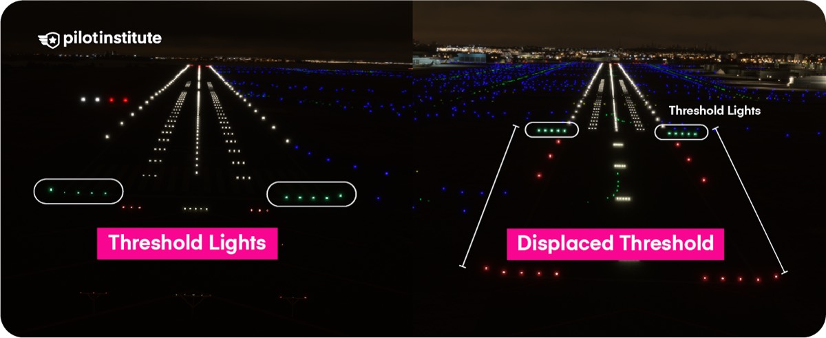
- displaced threshold: used due to obstructions, behind it [takeoff:O/landing:X]→ available length for landing↓, if [blast pad/chevron/stopway] comes right after displaced threshold?→[takeoff:X/landing:X]
- demarcation bar: behind it→not runway→[takeoff:X/landing:X]
- chevrons: yellow chevrons, pavement unusable for landing/takeoff/taxi
- stopway: clear area for jet/propeller blasts, additional tarmac for emergency
- shoulder: should avoid using
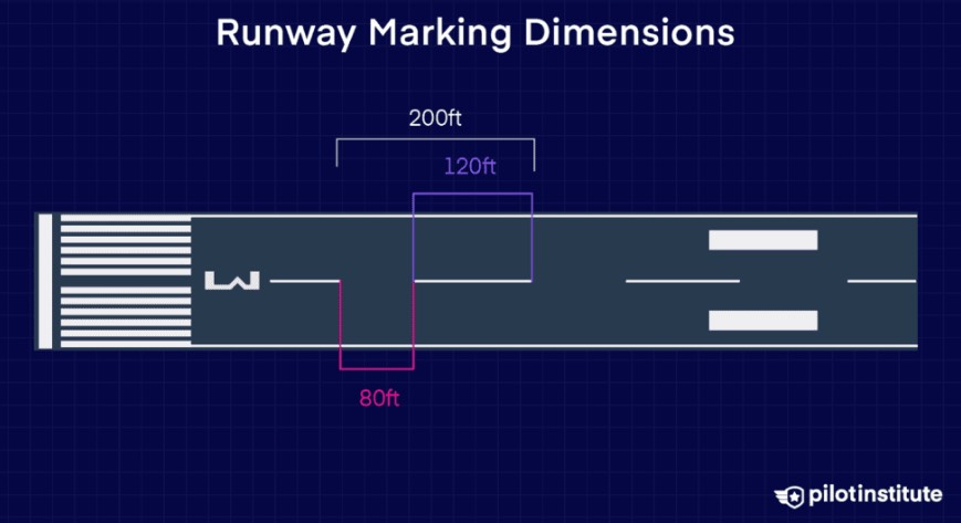
- centerline: centerline(120ft) + gap(80ft) = 200ft → used in RVR decision → 10 markings visible?→ RVR 2000ft
-
image: centerline
-
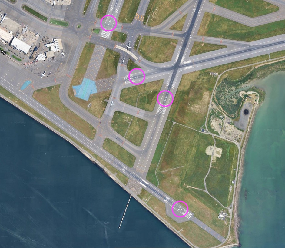
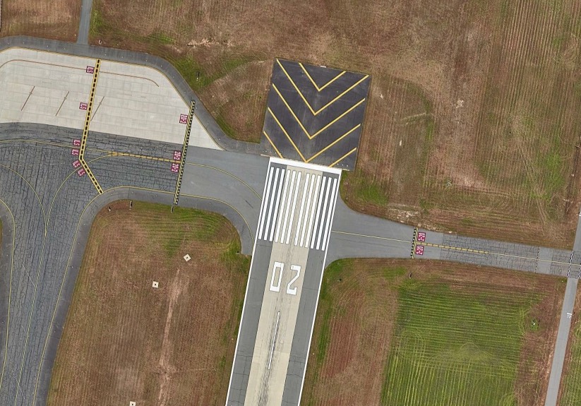
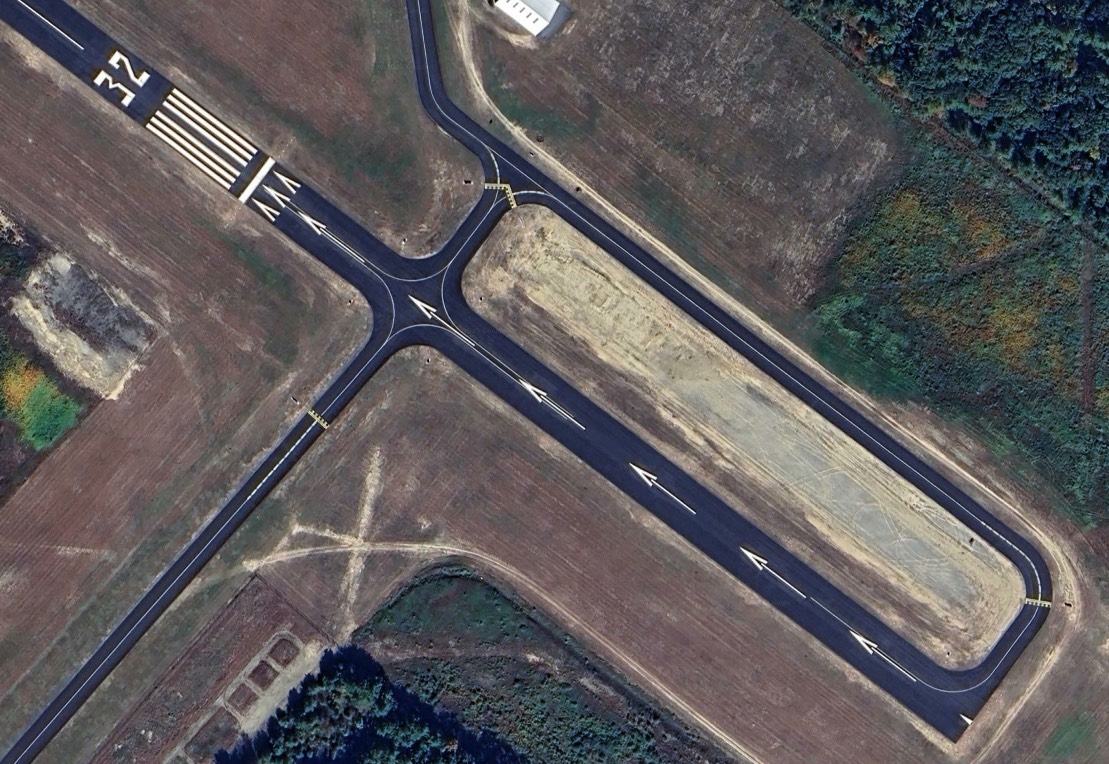
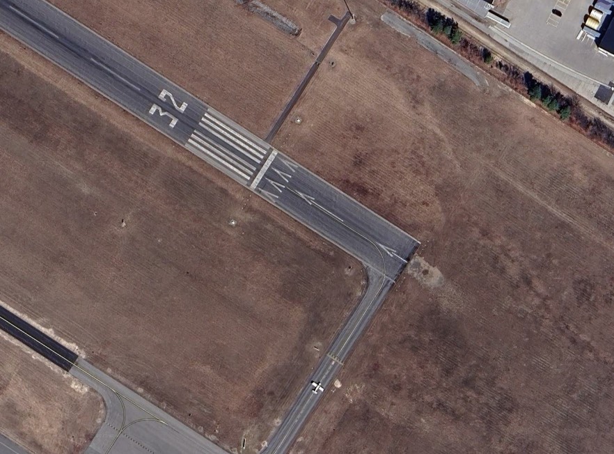
- examples: KBOS, KBAF, KORE, KASH
-
image: KBOS 4L, 4R, 9, 32
-
image: KBAF 20
-
image: KORE 32
-
image: KASH 32
-
-
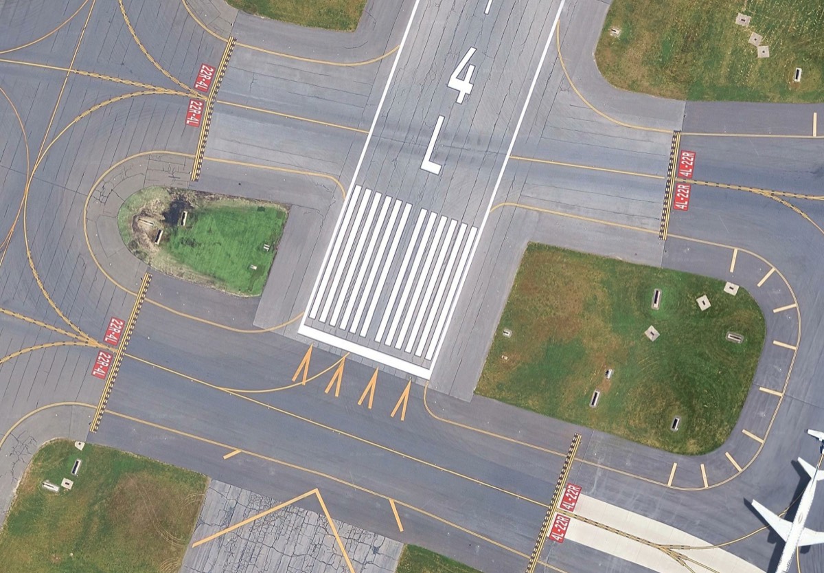
- taxiway: centerline, enhanced centerline, edge, shoulder, intersecting, vehicle roadway, VOR receiver checkpoint, non-movement area
-
image: taxiway
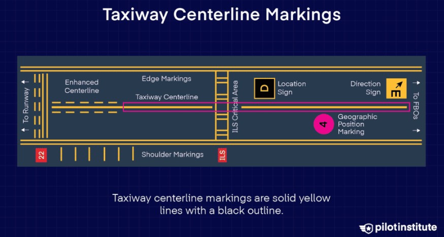
- centerline: solid yellow
- enhanced centerline: solid + yellow dashes, approaching rwy, max 150ft prior to hold-short line
-
image: enhanced centerline
-
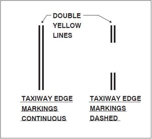
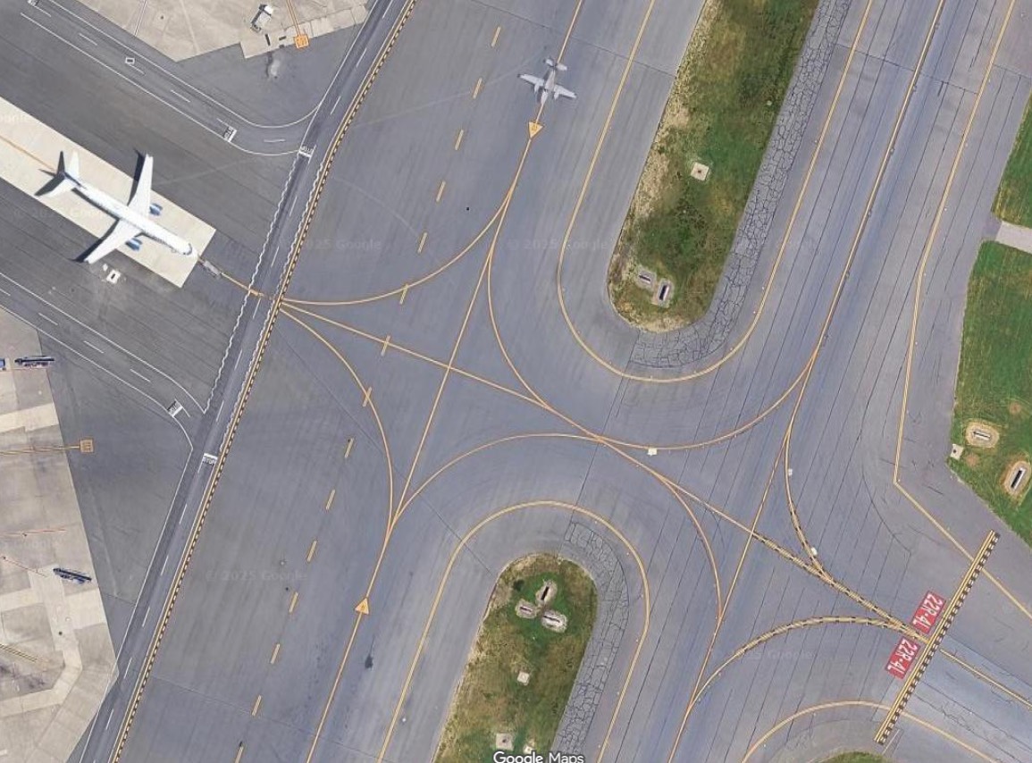
- edge: edge of taxiway, types[continuous-6inch/6inch, dashed-15ft/25ft]
- continuous: two yellow lines, each 6 inches wide and separated by 6 inches.
- dashed: double yellow lines, 15 ft long with 25ft gaps between them
-
image: edge
-
image: KBOS
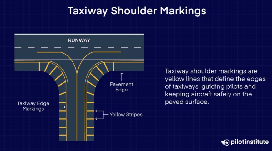
- shoulder: not intended to use, prevent vegetation/overruns
-
image: shoulder
-
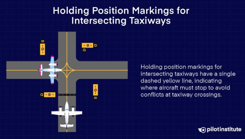
- intersecting taxiways: single dashed yellow
-
image: intersecting taxiways
-
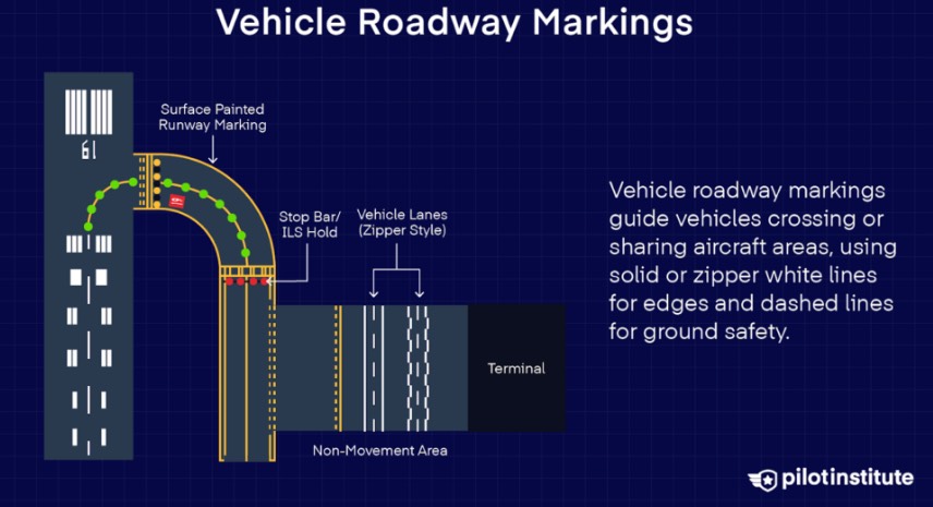
- vehicle roadway: white zipper lines
-
image: vehicle roadway
-
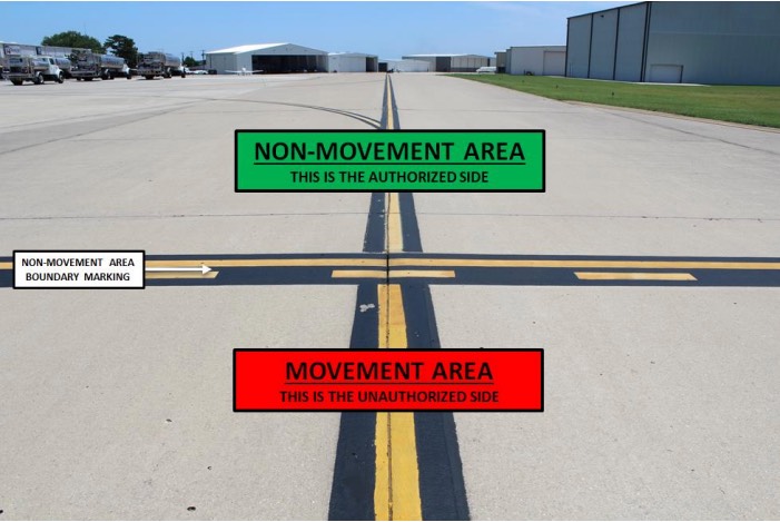
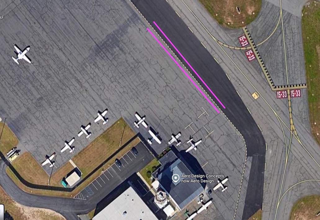
- non-movement area boundary: solid/dashed yellow, solid side (ramps/aprons), not controlled by ATC, free to move inside, clerance required to cross solid line)
-
image: non-movement area boundary
-
image: KBAF
-
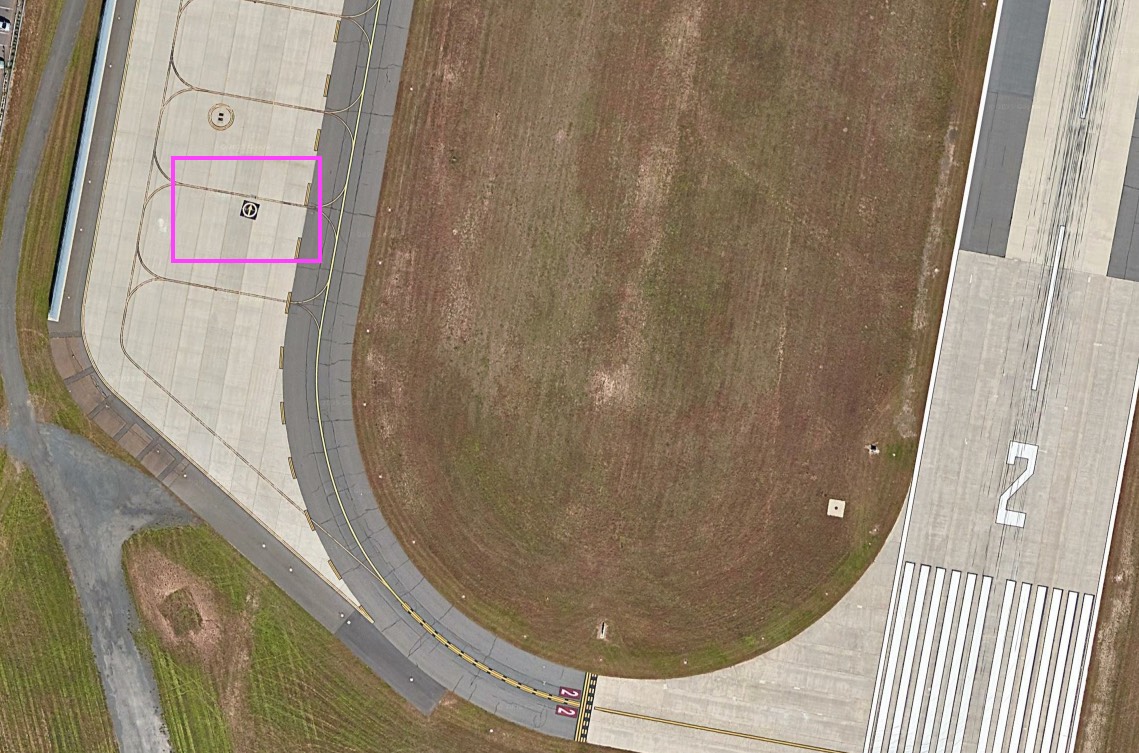
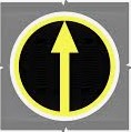
- VOR receiver checkpoint: yellow arrow circle, pointing direction of checkpoint azimuth
-
image: near KBAF RWY 2, VOR receiver checkpoint, pointing BAF VOR
-
image: VOR receiver checkpoint
-
-
- runway & taxiway lights
- approach lighting system (ALS)
- transition (instrument-guided to visual), Rabbit (twice a sec), threshold~approach (precision:2400~3000’ ALS, non-precision:1400~1500’ ALS)
- MALSR, ALSF-1, ALSF-2
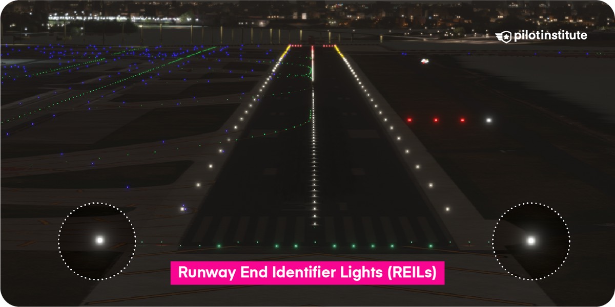
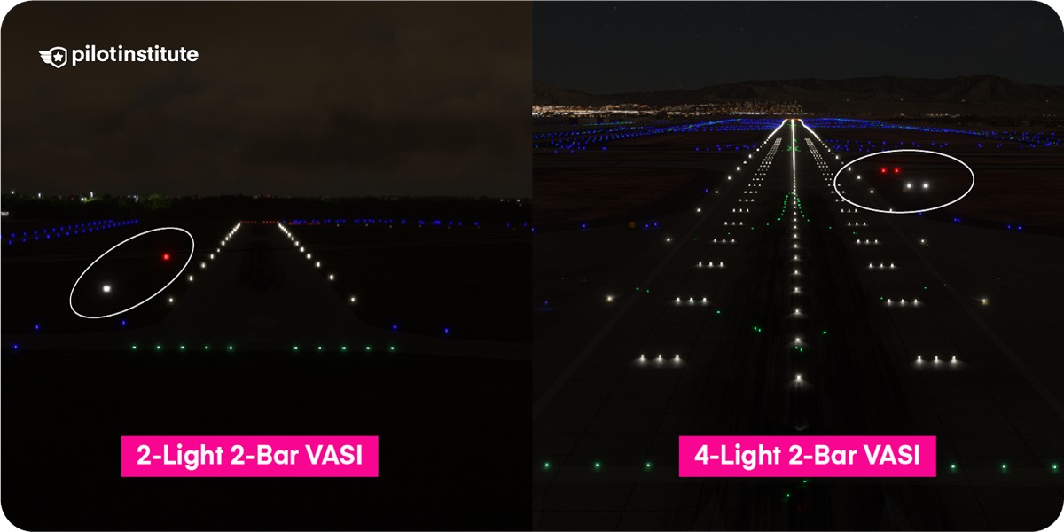
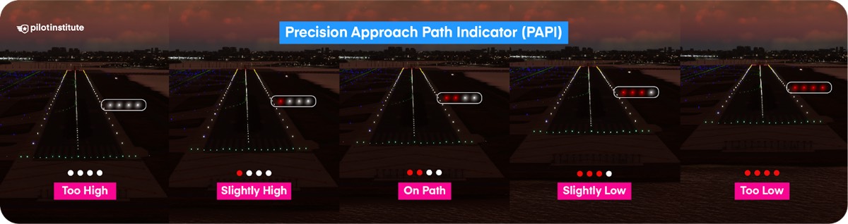
- REIL(threshold/flashing), VASI, PAPI
-
image: REIL
-
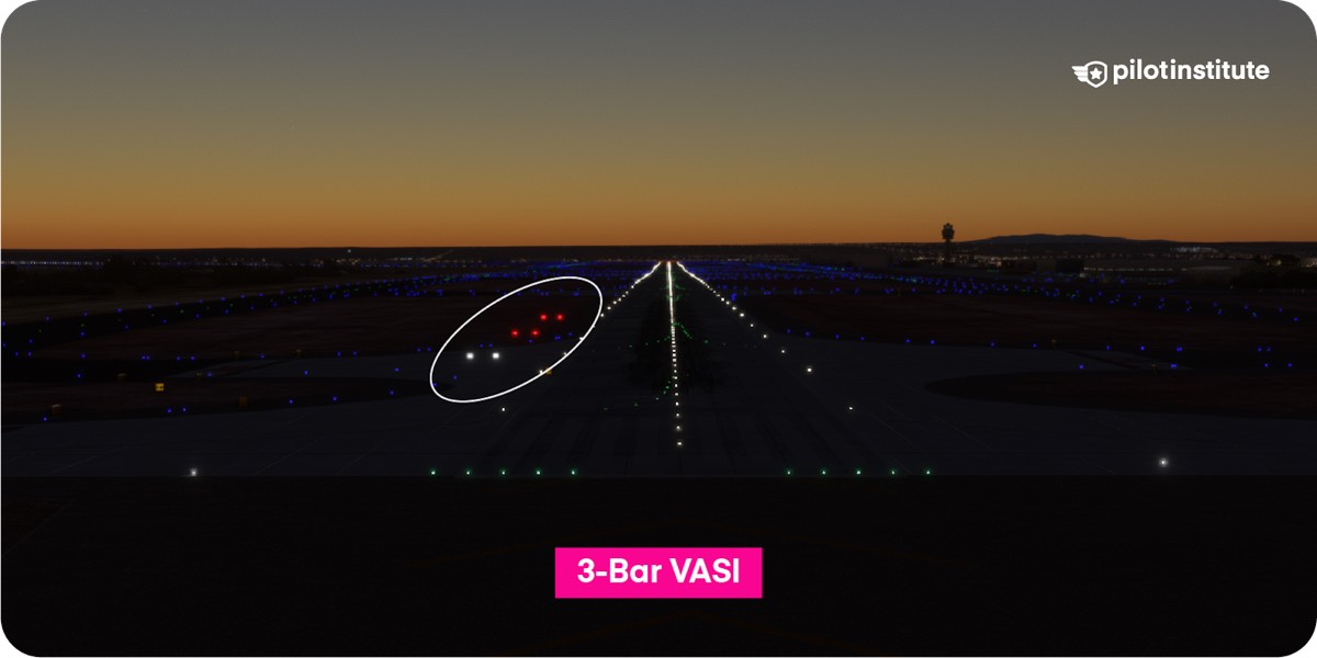
- 3-bar VASI: near&middle→lower glide path (3°), middle&far→upper glide path (+1/4°, ~3.25°, high-cockpit aircraft)
- threshold lights
-
image: threshold lights
-
- visual only rwy
-
image: visual only rwy
-
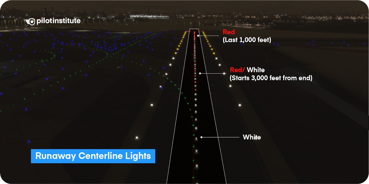
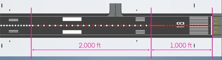
- rwy centerline: every 50ft, w-until last 3000ft & last 3000ft (w/r 2000ft, r 1000ft)
-
image: rwy centerline
-
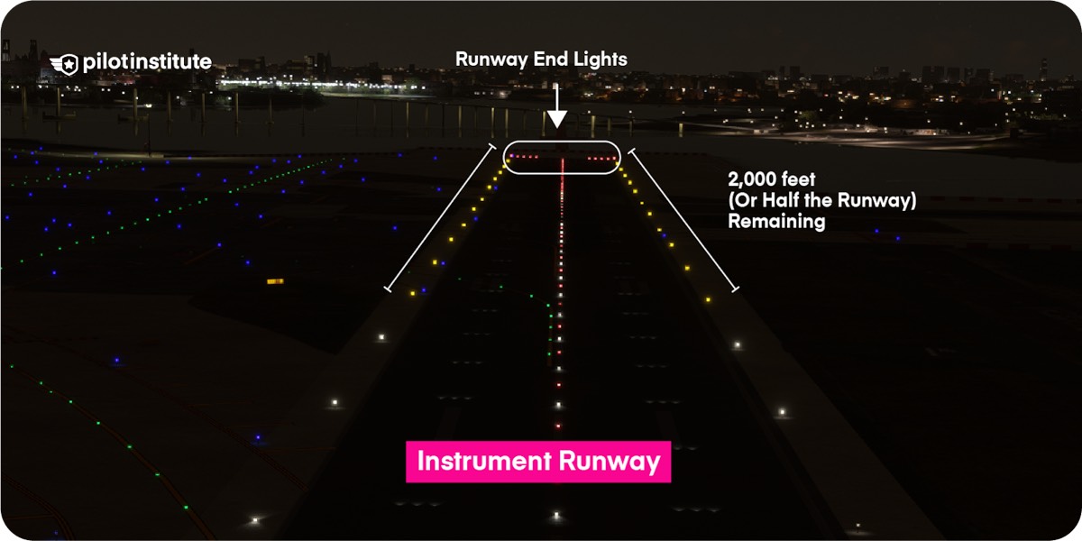
- rwy edge: white, instrument rwy → yellow last 2000ft or half rwy (whichever less)
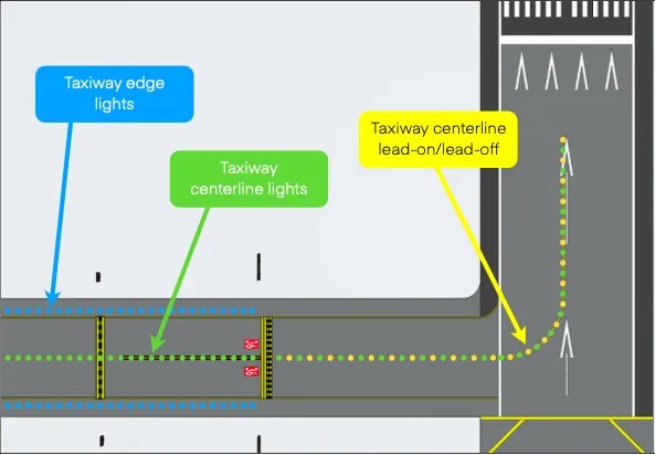
- taxiway: edge(blue), center(green), lead-on/off(green/yellow)
-
image: taxiway
-
- approach lighting system (ALS)
- signs & runway/taxiway boundary
- hold short line
-
image: hold short line
-
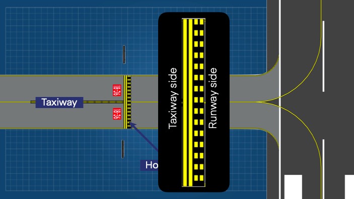
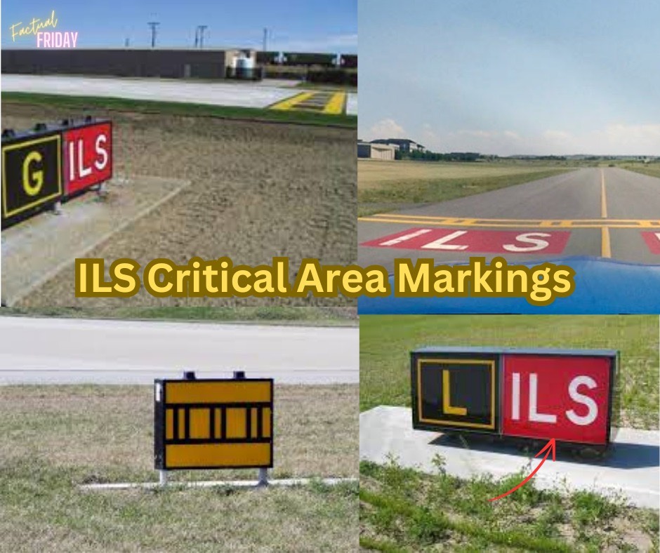
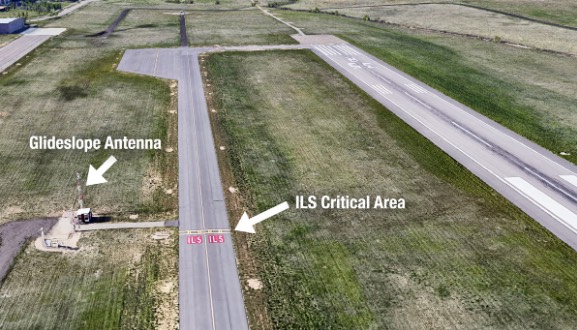
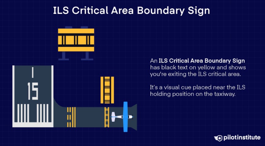
- ILS critical area: ATC protects when [ILS traffic at OM/FAF, ceiling<800, vis<2], “hold short of ILS critical area”→must stop
-
image: ILS critical area
-
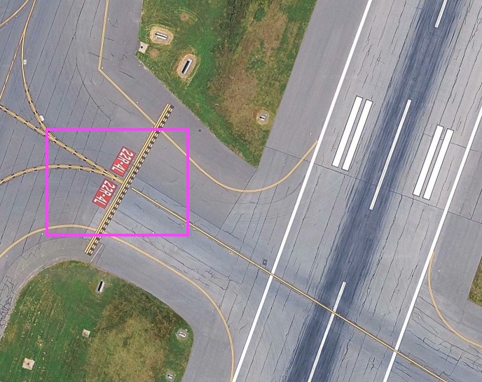
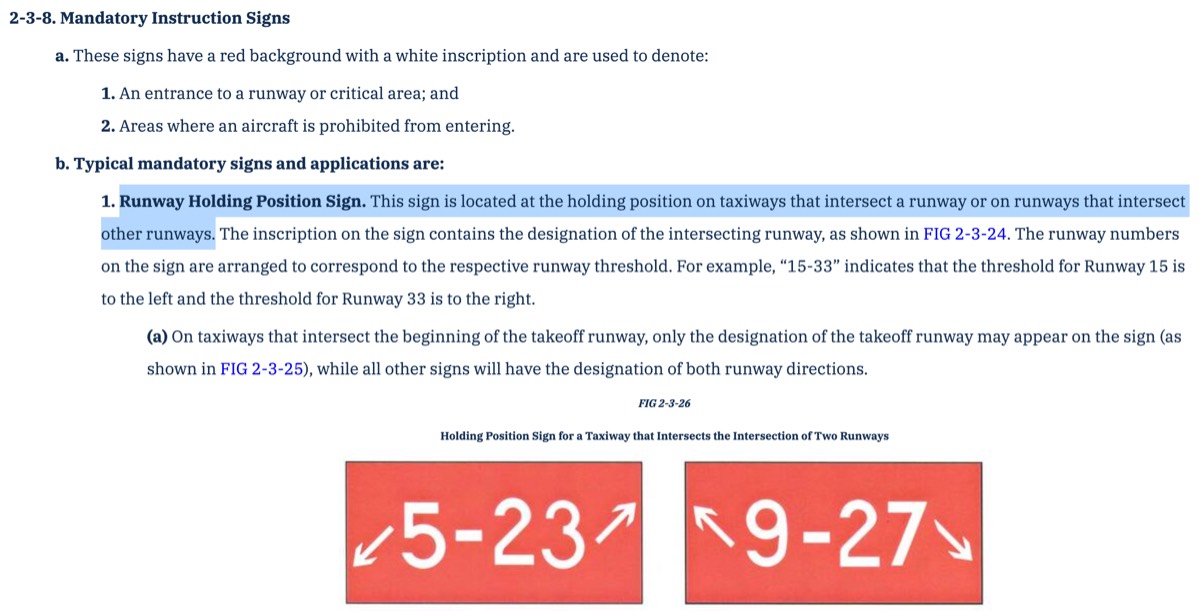
- runway holding position sign: taxiway&runway intersection or runway&runway intersection, cross?→runway
-
image: runway holding position sign
-
image: AIM 2-3-8
-
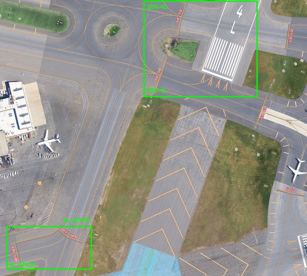
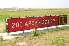
- runway approach area holding position sign: 4L-APCH, cross?→still taxiway
-
image: runway approach area holding position sign
-
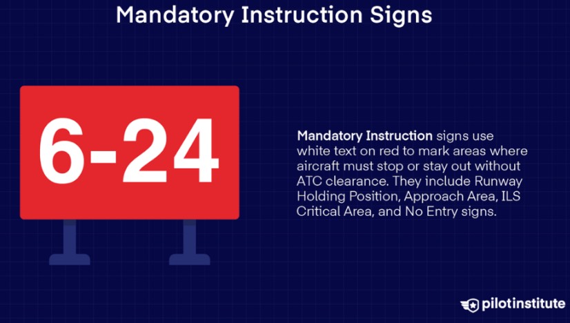
- signs (mandatory): red/white, never cross without ATC clearance → runway holding position, runway approach area, ILS critical area, no entry
-
image: signs (mandatory)
-
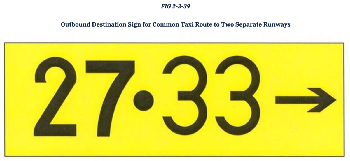
- signs (dotted): common taxiway to multiple destinations
-
image: signs (dotted)
-
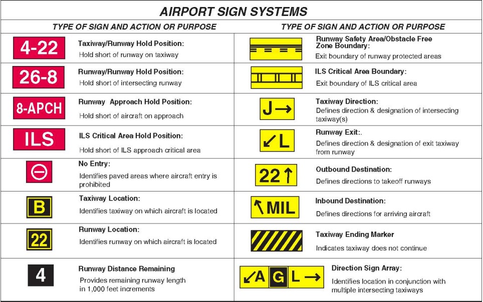
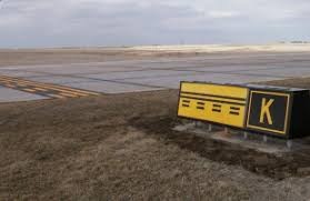
- signs (others): location, distance, information, direction, destination
-
image: signs (others)
-
- hold short line
- collision avoidance: takeoff→clear final&rwy, climb/descend/maneuver→L/R bank clear space, straight&level→scan traffic, vis↓&below10000ft(day/night)→turn on landing light, know blind spot(high/low wing), head-on→no relative motion
Airspace
- airspace on charts
-
image: Aeronautical Chart Users’ Guide
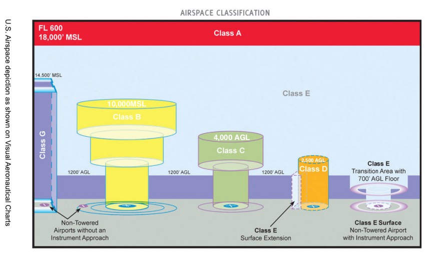
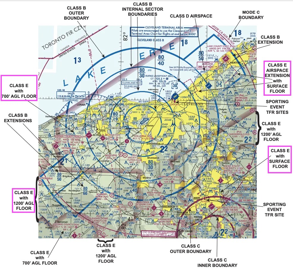
- airspace in VFR Sectional Chart
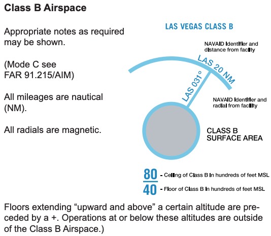
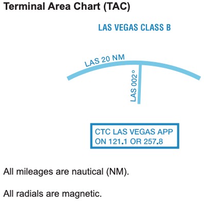
- class B (sectional, terminal)
-
image: class B (sectional, terminal)
-
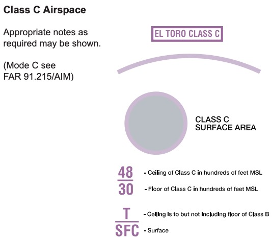
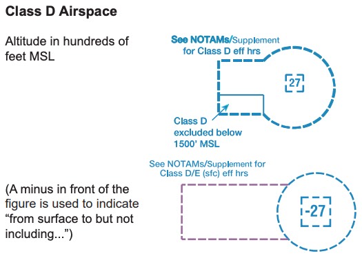
- class C & D
-
image: class C & D
-
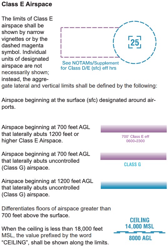
- class E
-
image: class E
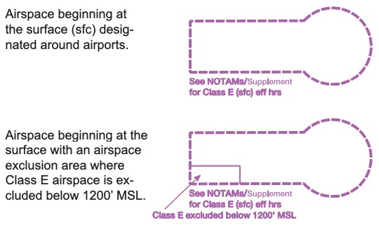
-
- class B (sectional, terminal)
-
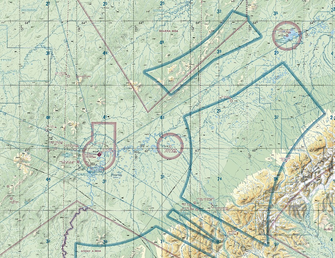
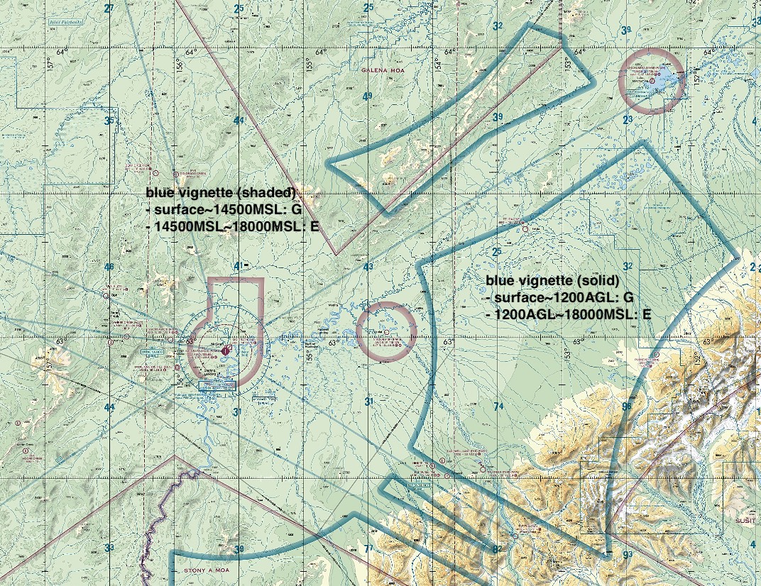
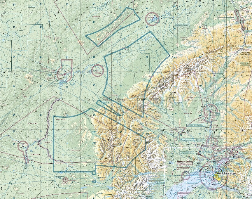
- class E blue vignette area (rare)
- blue vignette (solid): class E (1200AGL~18000MSL) ends at the vignette edge
- blue vignette (shaded): outside → class G (SFC~14500MSL)
- idea: keep controlled airspace (class E) only where it’s worth it (IAP airports, main routes, mountain passes), not everywhere
-
image: PAMC (MC GRATH), 16Z
-
image: PAMC (MC GRATH), 16Z, blue vignette comment
-
image: PAMC (MC GRATH), 16Z, zoom-out, Anchorage
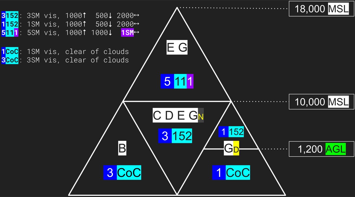
- why these cloud clearances?
- B → CoC: heavy traffic, wider cloud clearance would only limit ATC’s flexibility → relaxed weather rule, strict ATC rule
- G 1200↓ day → 1 CoC: low & slow traffic, no ATC/radio required, stricter minimums would make flying almost impossible → “see and avoid clouds carefully”
- C/D/E 10000↓ → 3152: controlled airspace, VFR & IFR mixed → room to see IFR traffic popping out of clouds
- E/G 10000↑ → 5111: no 250kt limit above 10000 → need to see farther
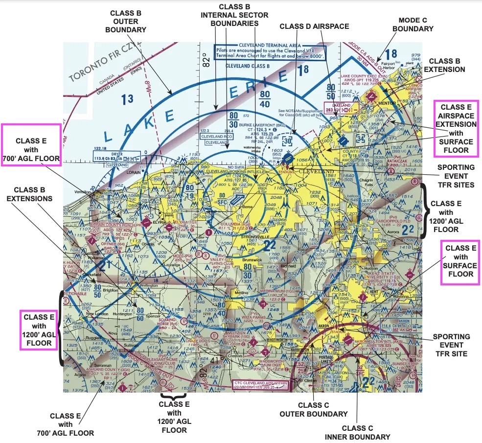
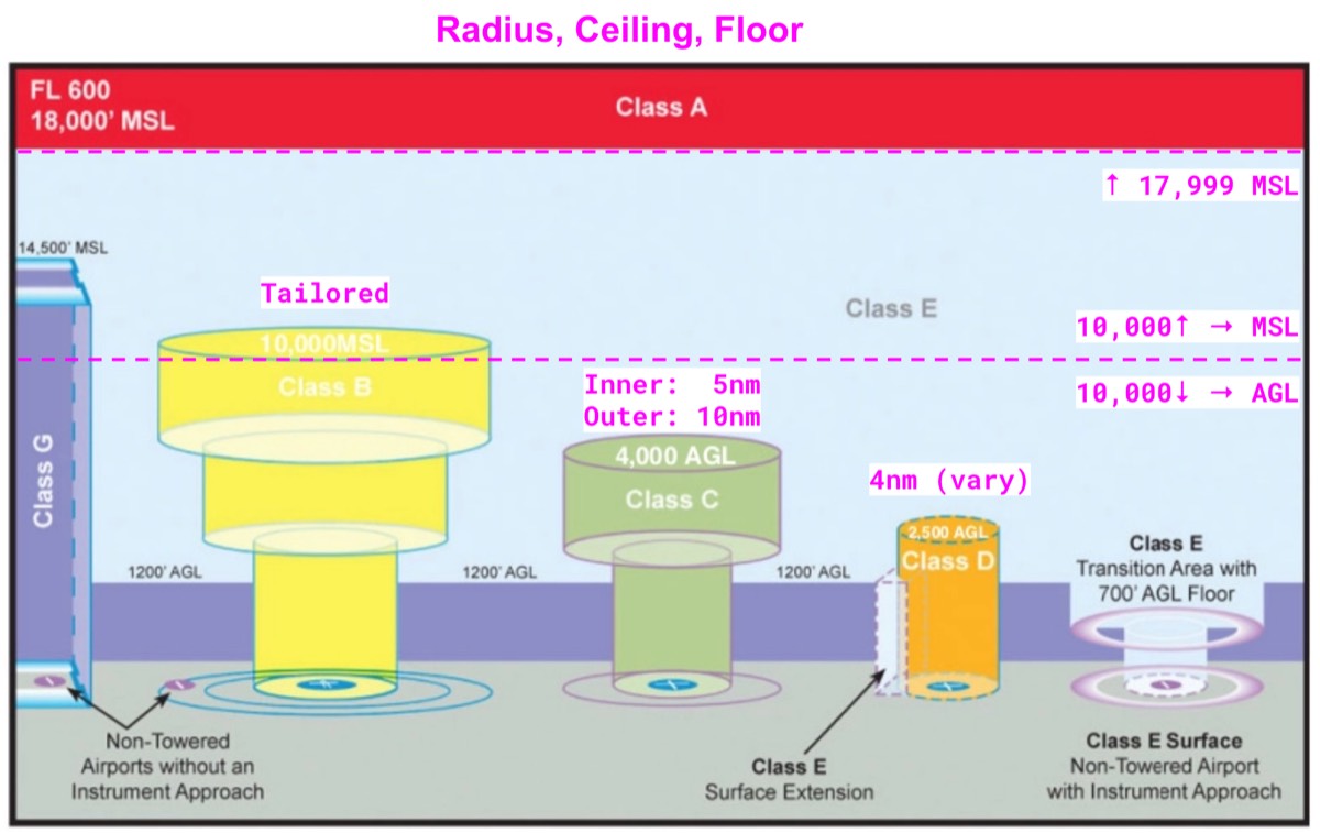
- weather & VFR sectional chart & boundary & requirements
- class E zipper line (off-shore/remote area)
- (below is class G, radar service not provided)
- class E base starts at 0000MSL marked
-
image: class E base starts at 0000MSL marked
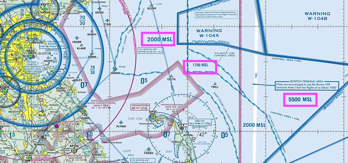
-
- LEFT: class E base starts at 5500MSL, RIGHT: class E base starts at 1200AGL
-
image: LEFT
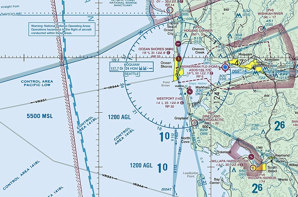
-
- airspace speed
- 250 kt: 10,000 MSL↓ (everywhere)
- 200 kt: within 4 NM & ≤2,500 AGL of class C/D
- 200 kt: below Class B (or VFR corridor)
- airspace altitude AGL/MSL
- above 10,000 → MSL
- below 10,000 → AGL
- UAS: unmanned aircraft system, typically 400AGL (vary), lowest priority right-of-way
- special use airspace: MCPRAWN
- AIM 3-4-1(c): MCAWN → nonregulatory (but better stay clear)
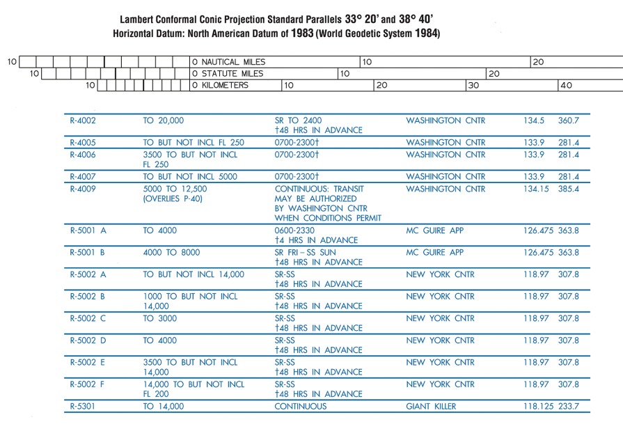
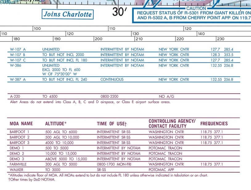
- *chart edge → detailed info
-
image: chart edge → detailed info
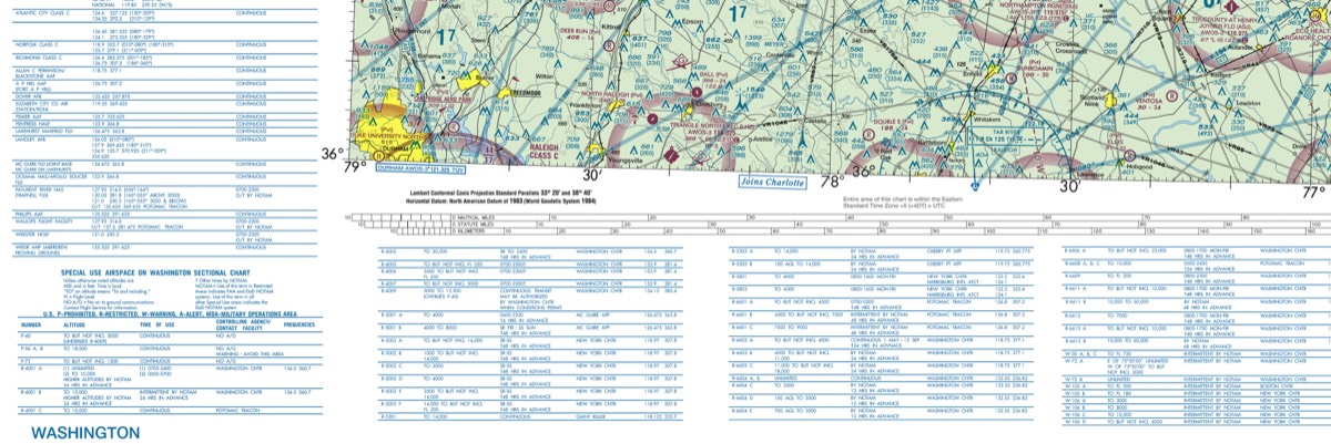
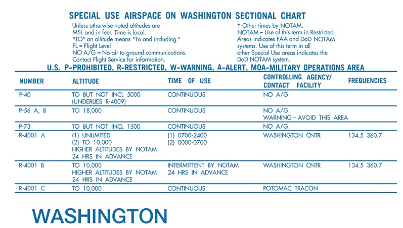
-
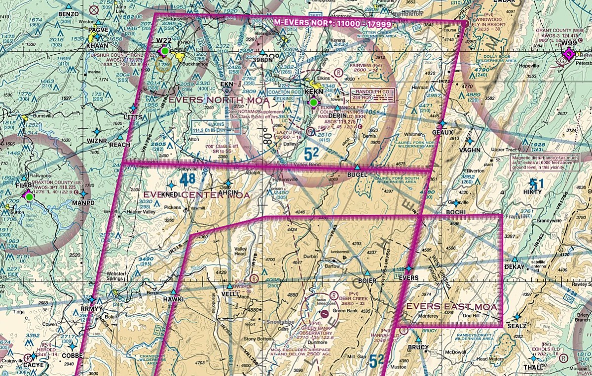
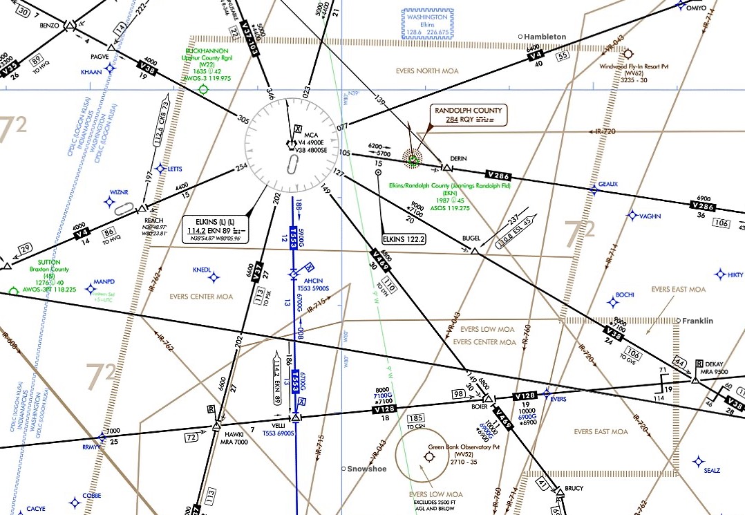
- MOA: military training; VFR may transit without permission, but exercise caution + check if active (controlling agency/FSS). IFR separated by ATC.
-
image: MOA
-
- CFA(controlled firing): not charted — firing stops when an aircraft is detected, so charting is unnecessary (not “location unknown”).
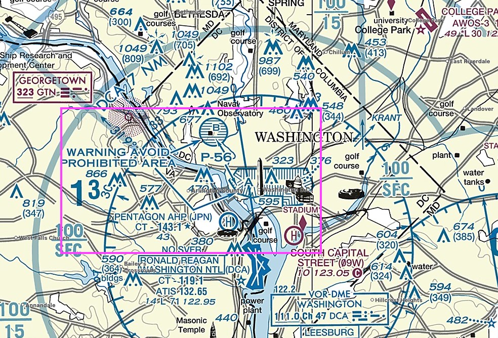
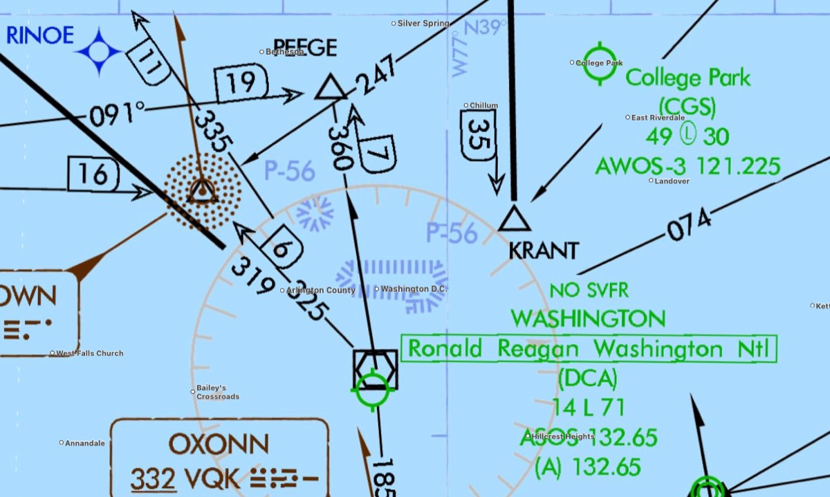
- Prohibited [P-xxx]: security reasons; flight always prohibited (not allowed)
-
image: Prohibited P-
-
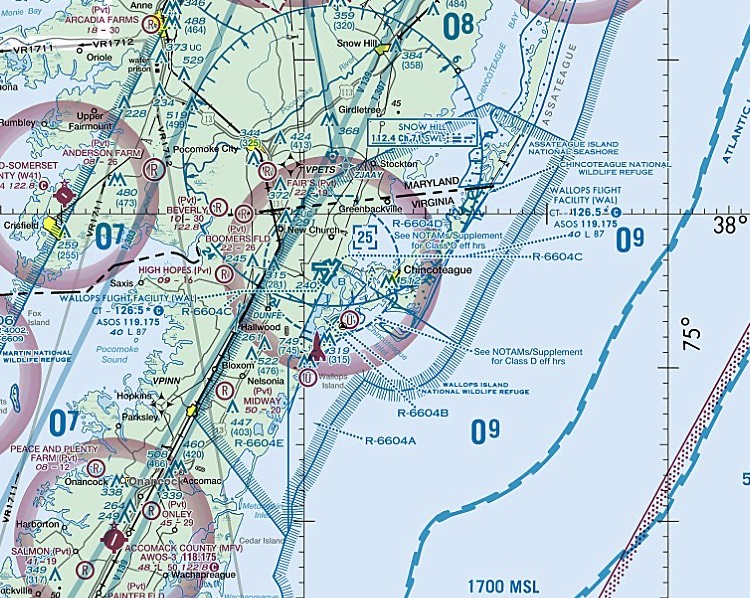
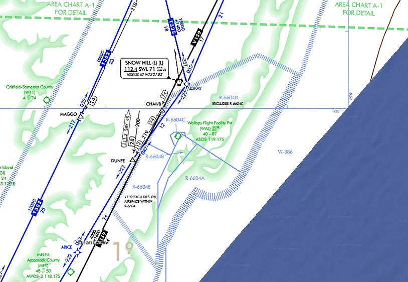
- Restricted [R-xxx]: hazardous activity (e.g. firing); permission required if active, inactive & released to FAA→may transit, no specific clearance needed
-
image: Restricted R-
-
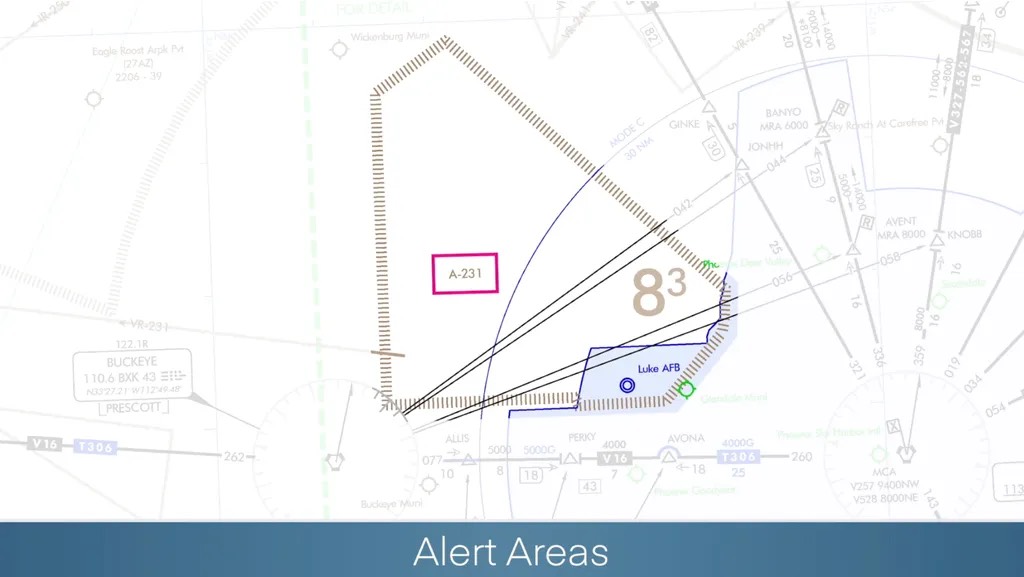
- Alerting [A-xxx]: high volume of training / unusual activity; no regulation, exercise caution.
-
image: Alerting A-
-
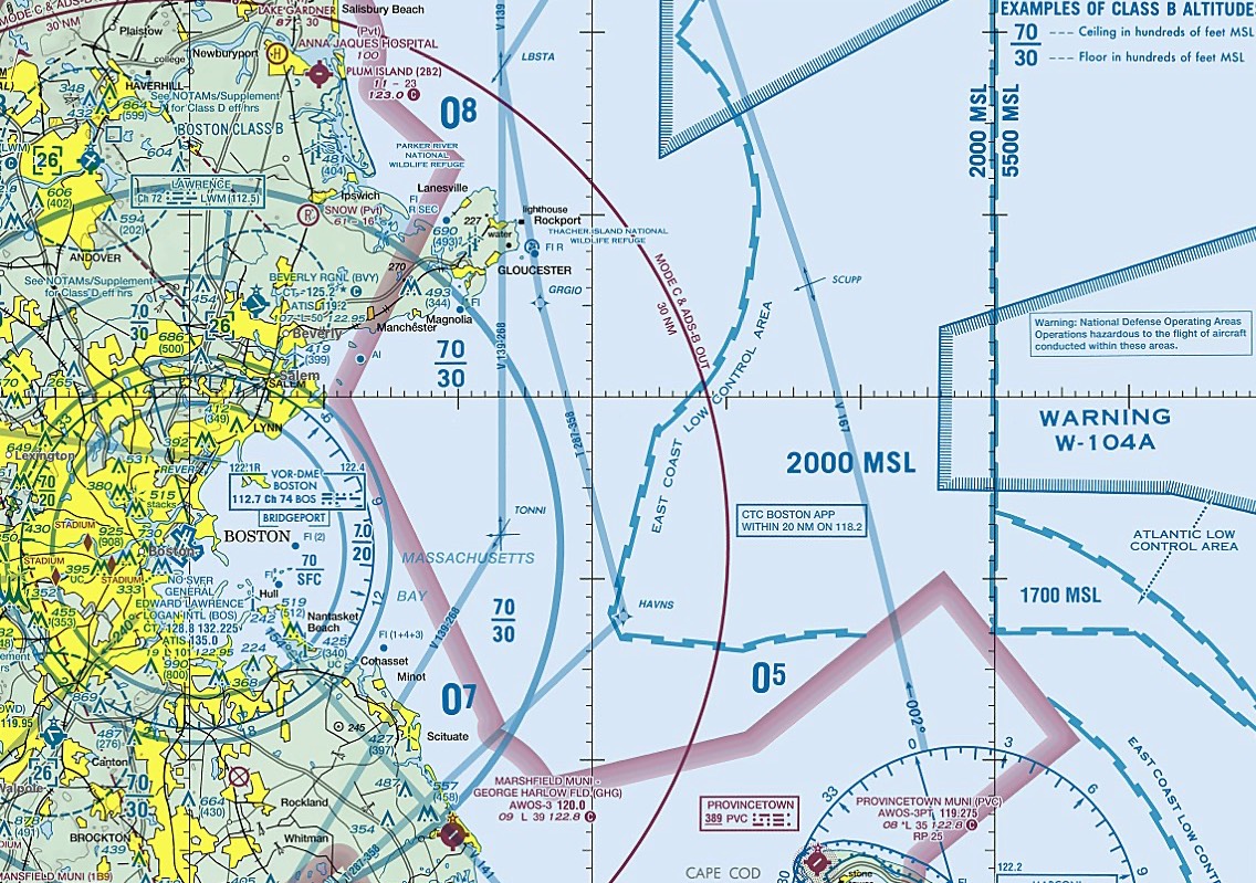
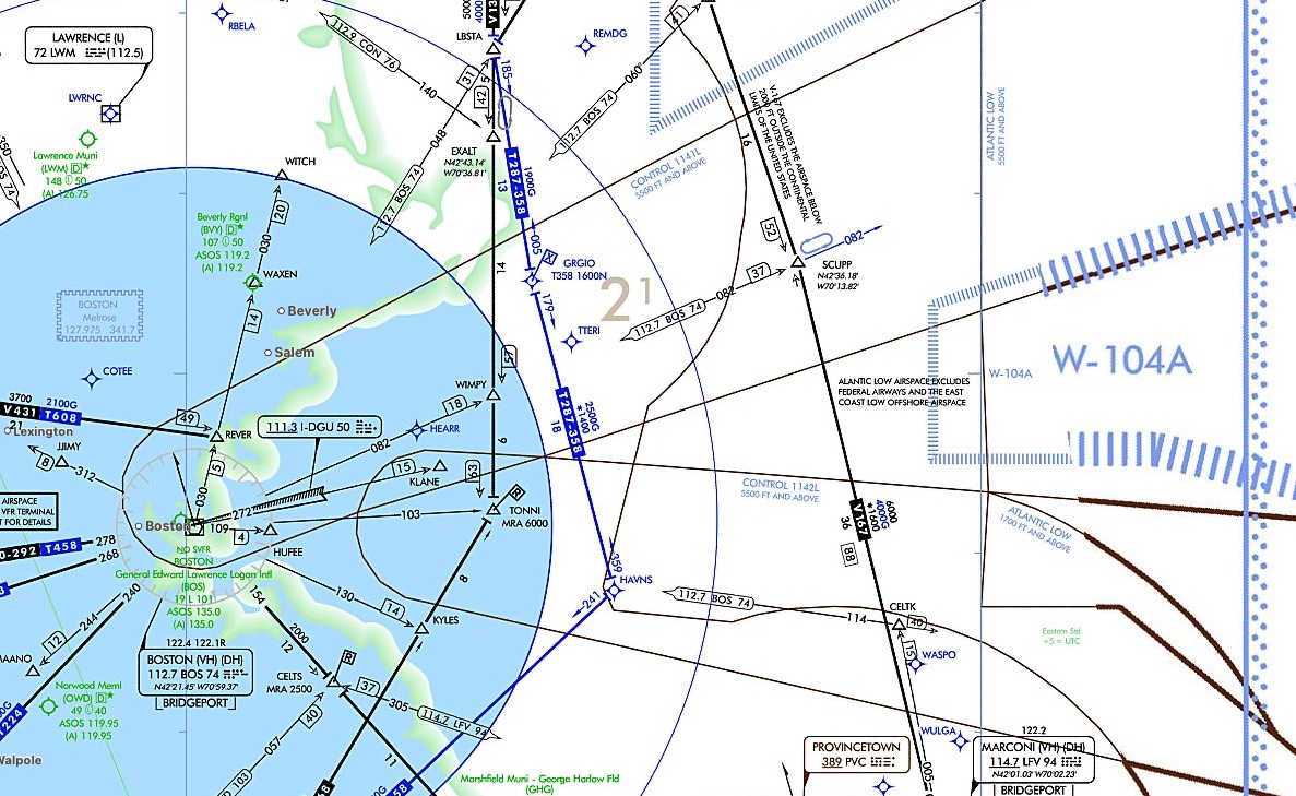
- Warning [W-xxx]: hazardous activity, from 3NM offshore, over domestic and/or international waters
-
image: Warning W-
-
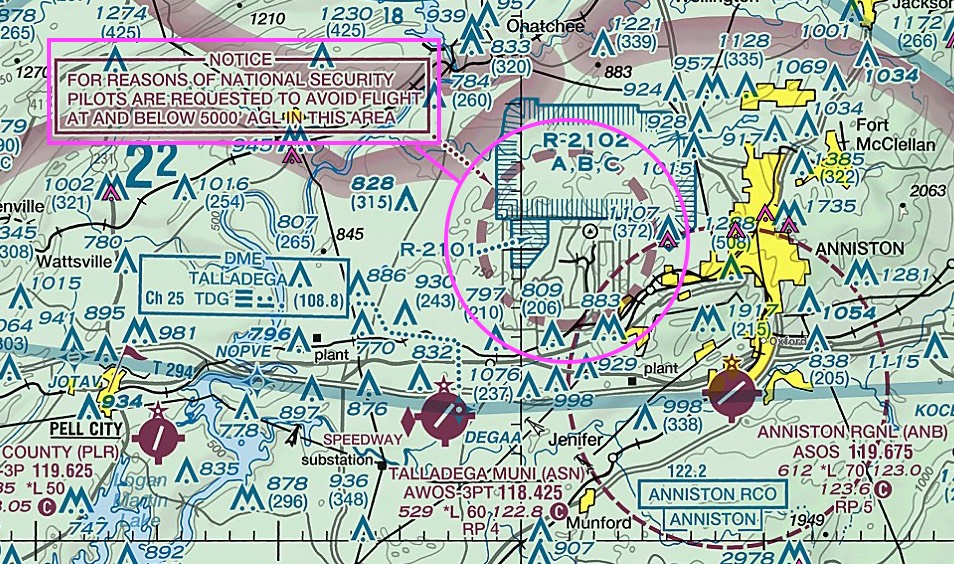
- NSA (national security area): protects ground facilities; voluntarily avoid, temporarily prohibited by NOTAM
-
image: NSA (national security area)
-
- other airspace: AIM 3-5
- TFR (Temporary Flight Restrictions): prohibited, [natural disaster, public-safety, VIP, space-ops]
- uncharted!→NOTAM
- charted magenta ◇ → sporting event TFR sites
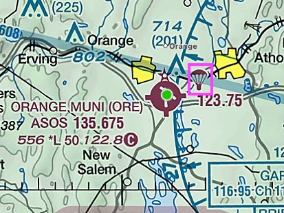
- PJA (Parachute Jump Area): monitor radio (announce drop), active?→avoid
-
image: PJA (Parachute Jump Area)
-
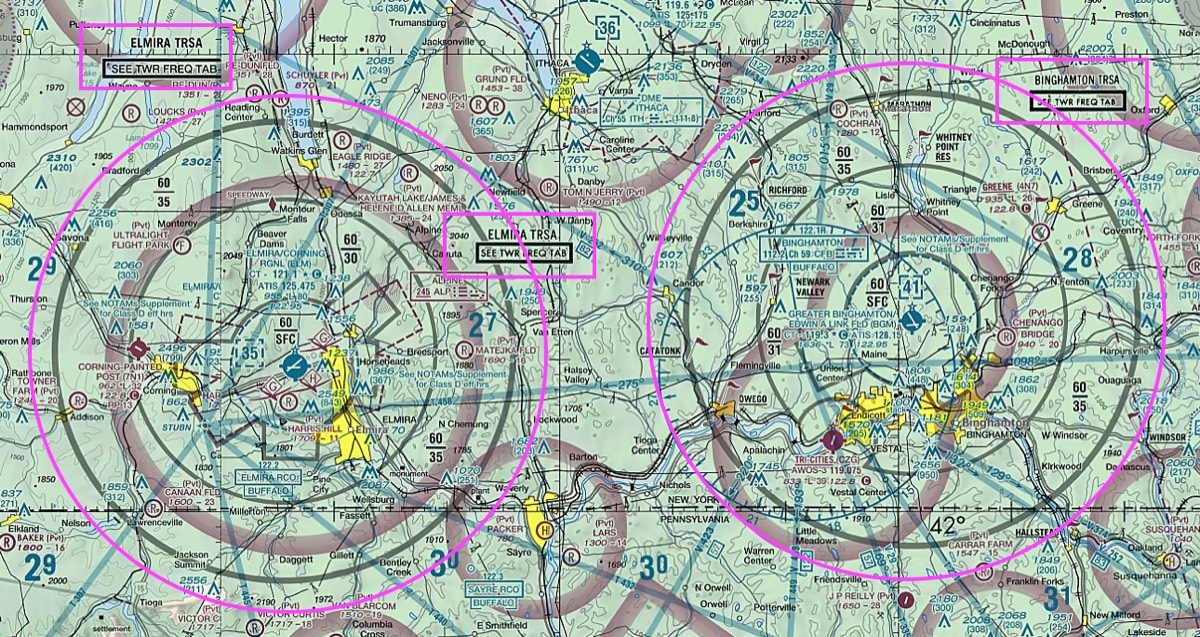
- TRSA (Terminal Radar Service Area): not an airspace class — radar service around a Class D primary airport, solid bold gray line, VFR participation is VOLUNTARY (recommended)
-
image: KELM TRSA, KBGM TRSA
-
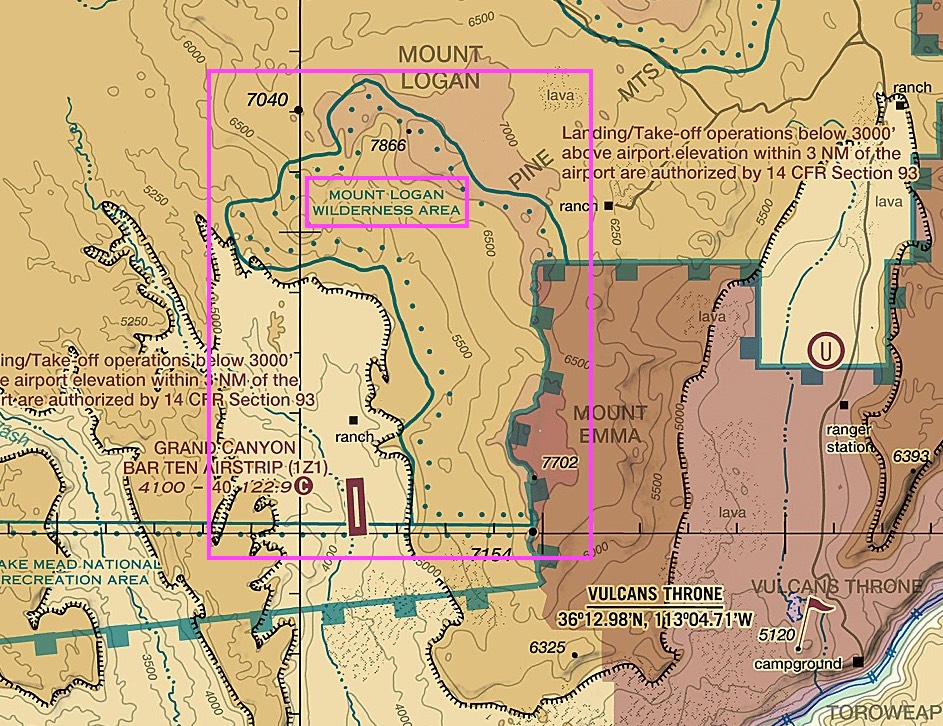
- Wilderness Areas: protect nature; 2,000 AGL courtesy request (national parks/refuges/forests)
-
image: Wilderness Areas
-
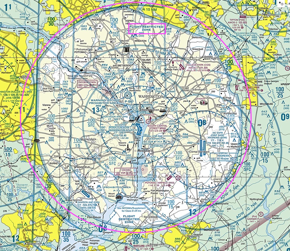
- FRZ (Flight Restricted Zones): ~13–15NM around DCA VOR/DME, SFC–FL180↓, inside DC SFRA (White House/Capitol core = P-56, prohibited)
-
image: around KDCA
-
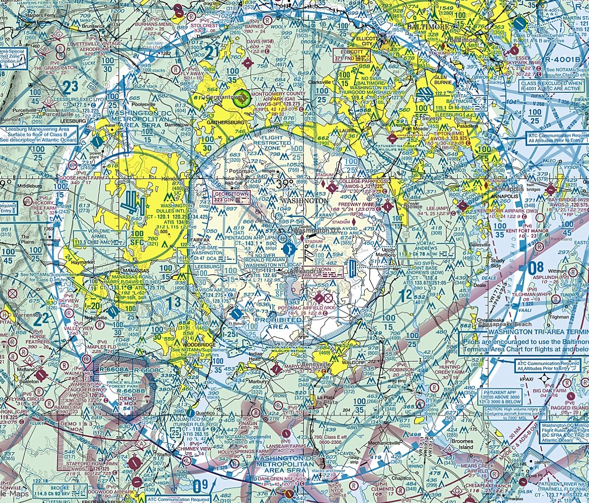
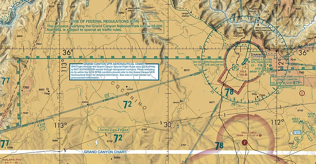
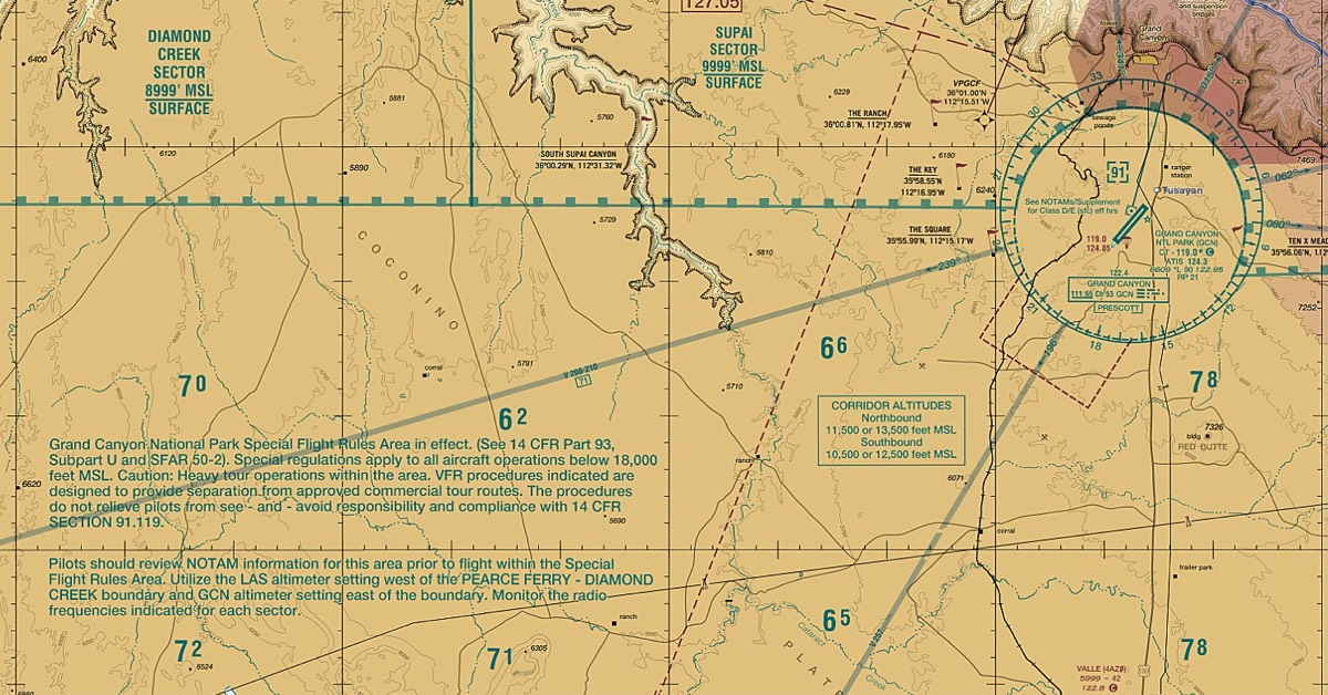
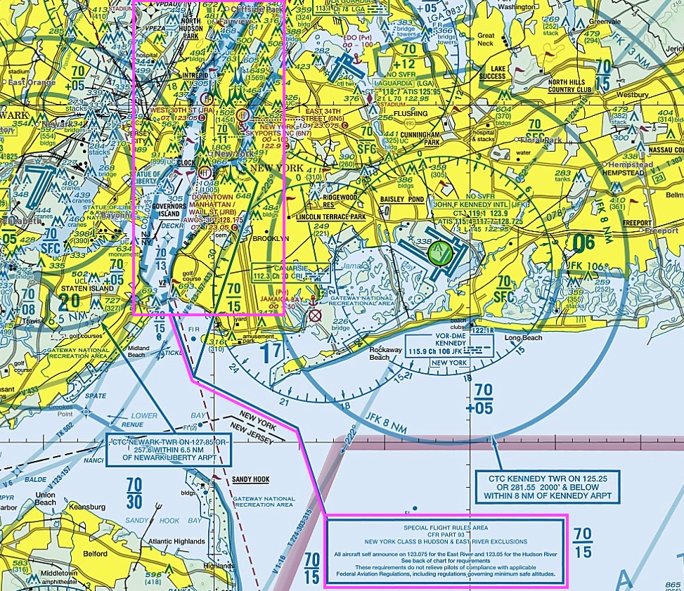
- SFRA (Special Flight Rules Area): Grand Canyon, Washington DC, Hudson River
- Washington DC SFRA: 30NM from DCA, national security, mandatory[SFRA flight plan (VFR), 2-way radio, squawk]
- *Special Awareness Training required for VFR pilots within 60NM of the DCA VOR
-
image: Washington DC SFRA
- Grand Canyon (GCN SFRA): Grand Canyon VFR Aeronautical Chart
-
image: Grand Canyon (GCN SFRA)
-
- Hudson River SFRA: no (squawk/ATC) ok, surface-1299ft, ≤140KIAS, anti-collision+position lights on (landing light recommended), self announce on CTAF at each reporting point
-
image: Hudson River SFRA
-
- Washington DC SFRA: 30NM from DCA, national security, mandatory[SFRA flight plan (VFR), 2-way radio, squawk]
- ADIZ (Air Defense Identification Zones): AIM 5-6, border in sky, require[2-way radio, transponder(+squawk code), IFR/DVFR flight plan, position report], returning US?→must land at customs airport
- MTR (Military Training Routes): VR/IR(VFR/IFR) routes, 4-digit→1500AGL↓(all), 3-digit→at least one segment 1500AGL↑, (+)Special Military Activity→gray ⇒ tip: build from the bottom, 4 digits below 1500AGL, 3 digits stacked above
-
image: MTR (Military Training Routes)
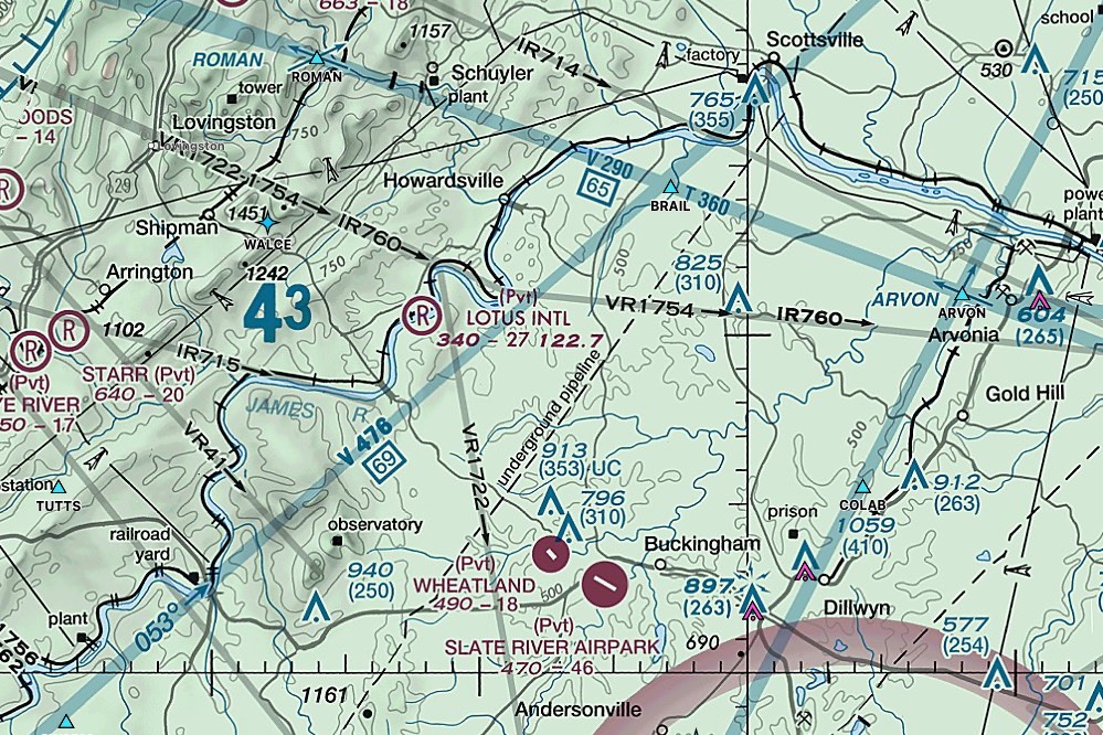
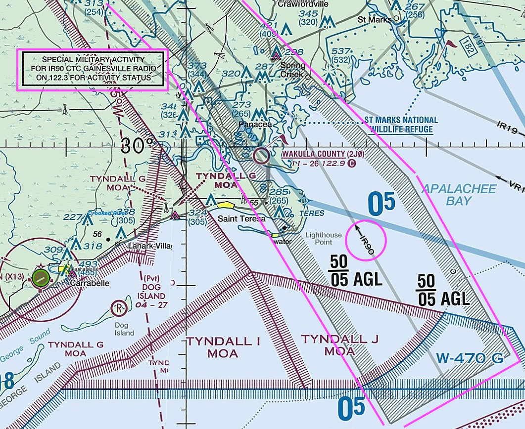
-
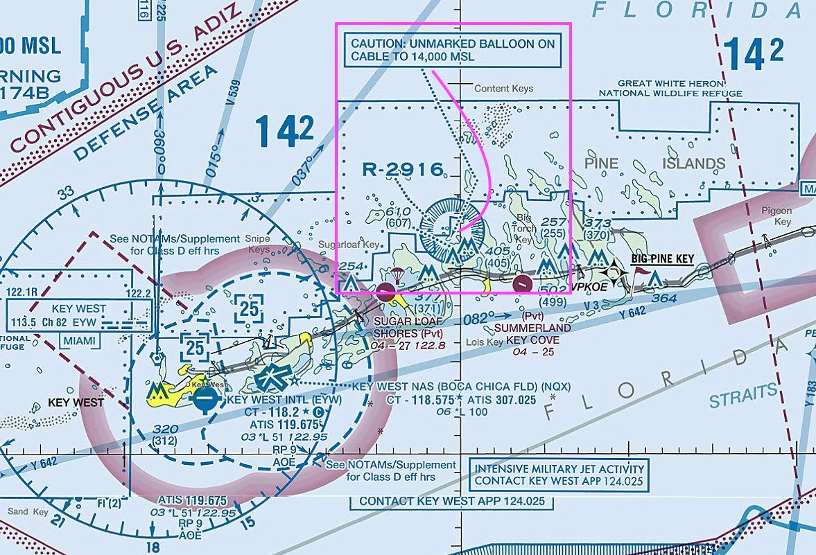
- (+) Unmarked Ballon on Cable to 14000MSL in Florida
-
image: near KEYW
-
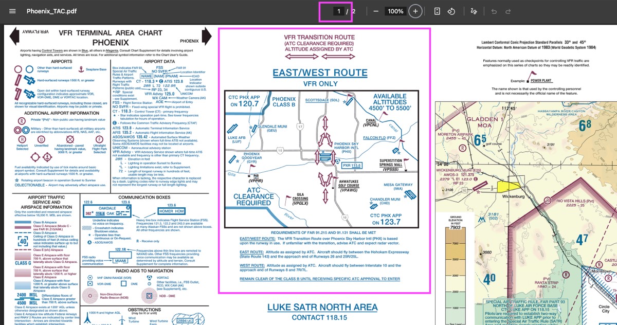
- VFR Routes:
- class B transition route → TAC (Terminal Area Chart)
- VFR corridor → TAC (Terminal Area Chart)
- VFR flyway → back of the TAC
-
image: Phoenix TAC page1
-
image: Phoenix TAC page2
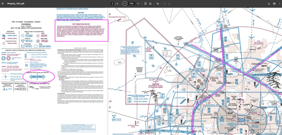
- LAA (Local Airport Advisories): only Alaska, advisory by FSS, within 10sm airport
- TFR (Temporary Flight Restrictions): prohibited, [natural disaster, public-safety, VIP, space-ops]
Charts
- sectional chart: 56days, 1”=500,000” (8mile),
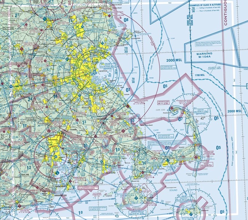
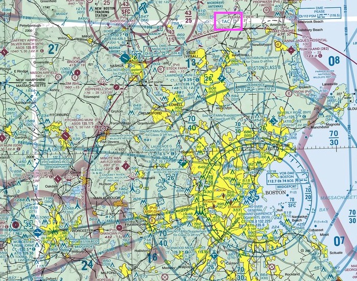
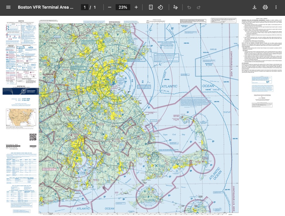
- terminal area chart (TAC): 1”=250,000” (4mile), for class B, shows transition, TAC white border in sectional chart, 56days
-
image: in Sectional Chart (TAC white border) #1
-
image: in Sectional Chart (TAC white border) #2
-
image: KBOS TAC
-
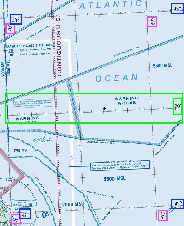
- latitude & longtitude: easy(flat&pole), equator&prime meridian(england), latitude(90°N/S→180°), longitude(360°), 1°=60minutes
- square in chart: each square 30min (1/2 degree) of lat/long, tic mark (1m / 5m / 10m)
-
image: square in chart
-
- 1 nautical mile: 6076ft(1.852km), minute of longitude at the Equator (1°=60minutes, 360°=21600minutes) → earth’s circumference=21600NM (21639.4NM)
- variation: diff[true N, mag N], changes over time, affecting rwy numbers, placed every 1/2° (except east of 5°W→1° spacing), east least west best
[FAA] Aeronautical Chart Users’ Guide
- airports
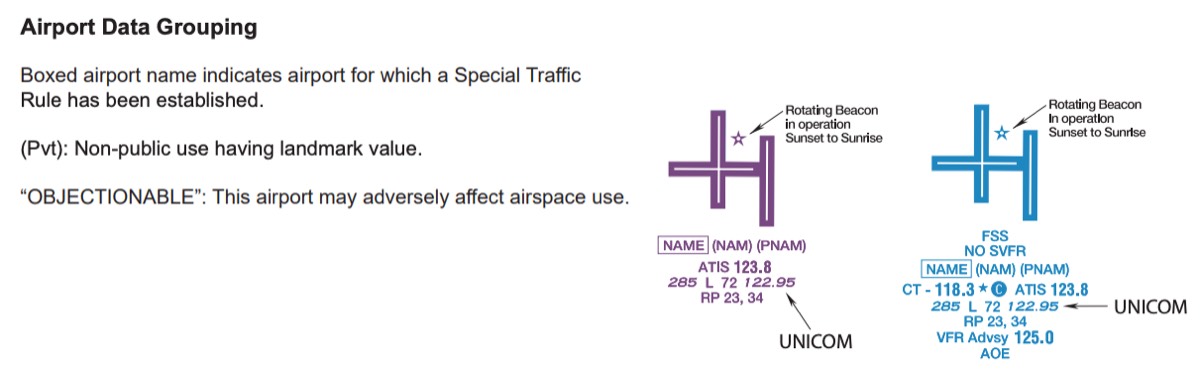
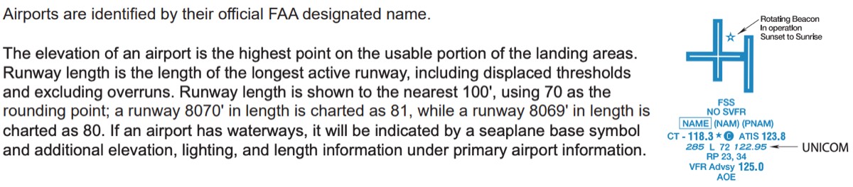
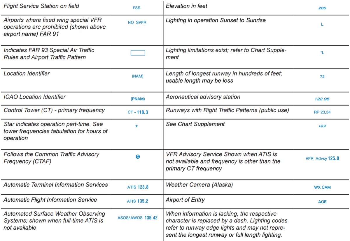
- airport data grouping
-
image: airport data grouping


-
- surface
-
image: surface
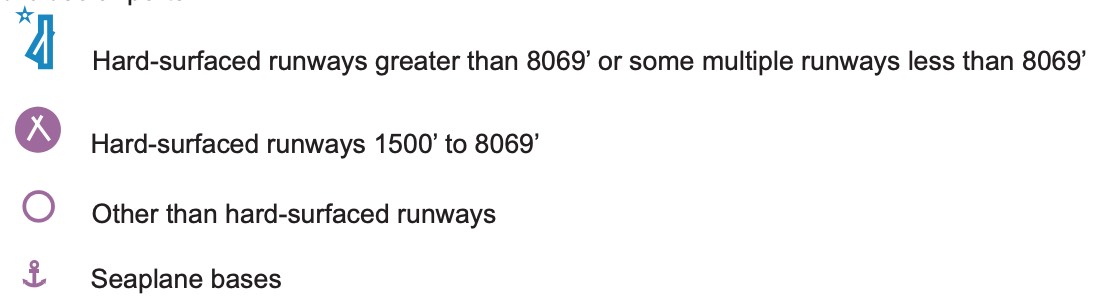
-
- airports
-
image: airports
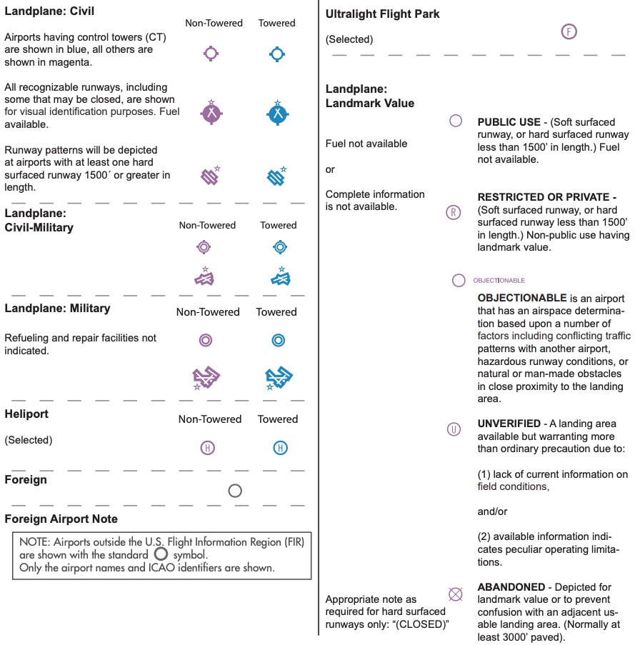

-
- fuel availability
-
image: fuel availability

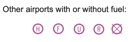
-
- beacons
-
image: beacons
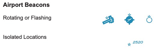
-
- airport data grouping
- terrain & obstructions
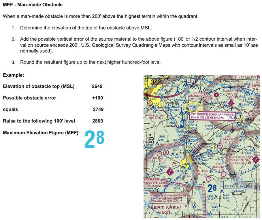
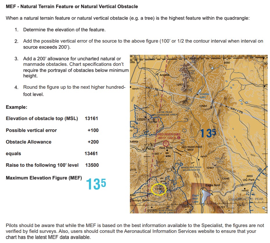
- MEF (maximum elevation figure): highest elevation within a quadrant, man-made[top+100→raise to 100’level], natural[top+100+200→raise to 100’level]
-
image: man-made based MEF
-
image: natural terrain MEF
-
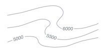
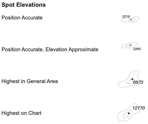
- contour lines: join points of equal elevation, basic interval 500’ (vary)
-
image: contour lines
-
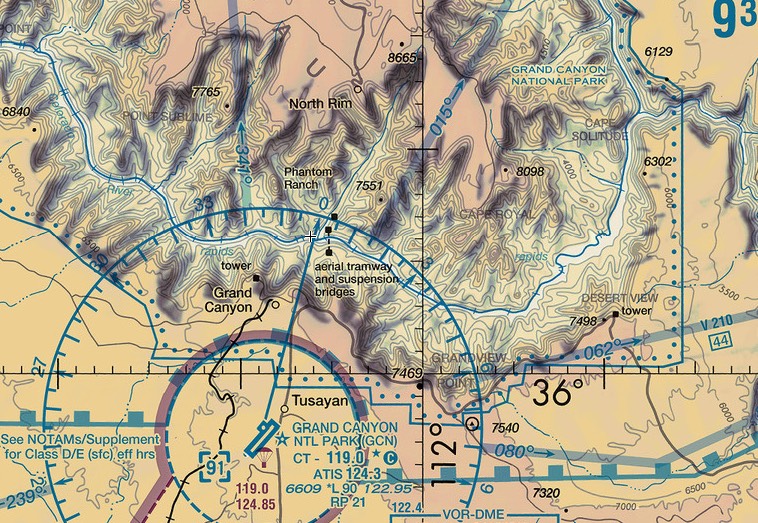
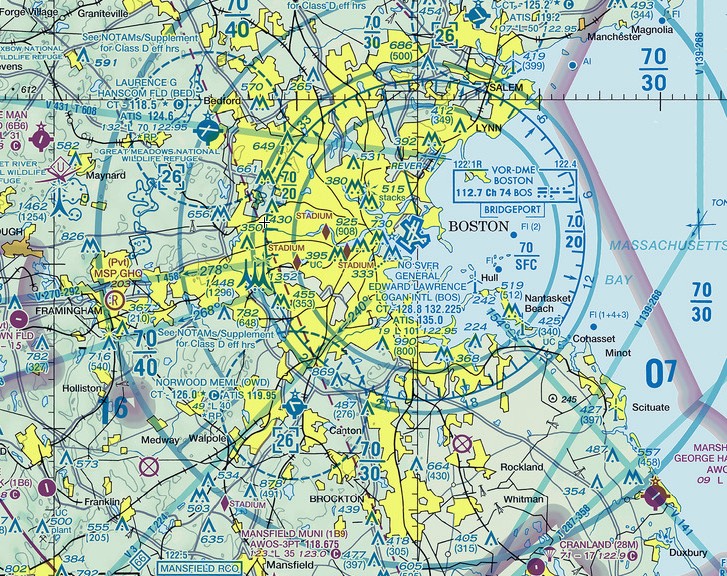
- terrain color: lower→light green, higer→dark brown
-
image: terrain color

-
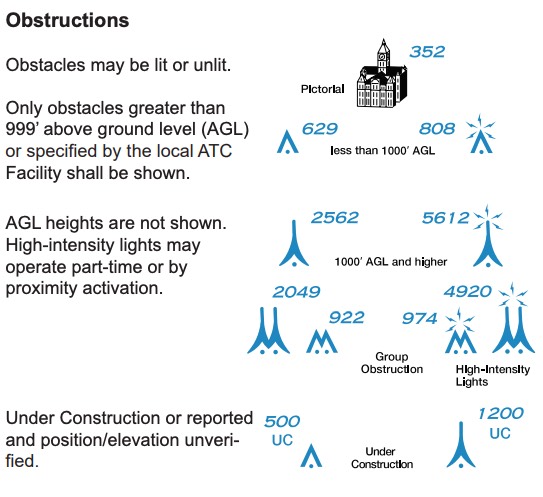
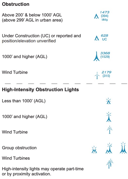
- obstructions
-
image: obstructions
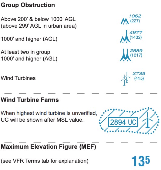
-
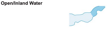
- culture (populated, railroad, roads, power lines, bridges)
-
image: culture (populated, railroad, roads, power lines, bridges)
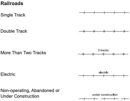
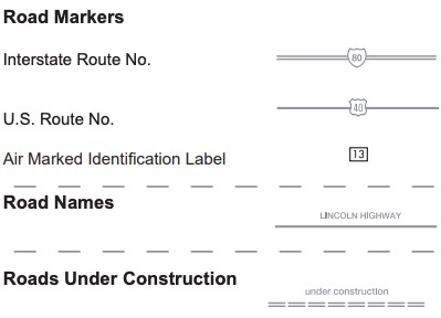
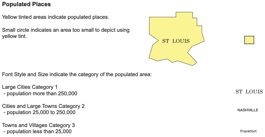

-
- MEF (maximum elevation figure): highest elevation within a quadrant, man-made[top+100→raise to 100’level], natural[top+100+200→raise to 100’level]
- routes
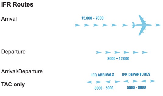
- IFR routes
-
image: IFR routes
-
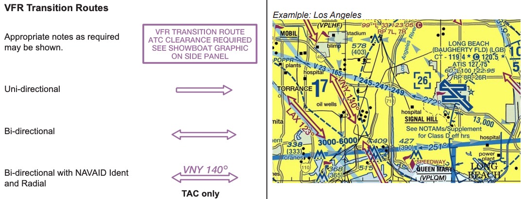
- VFR transition routes
-
image: ForeFlight shows TAC only on U.S. VFR layer
-
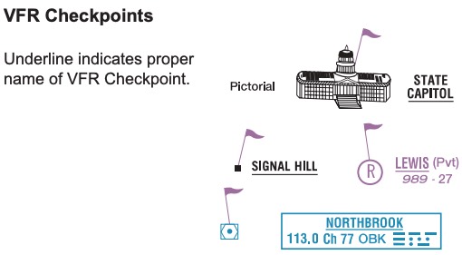
- VFR checkpoint
-
image: VFR checkpoint
-
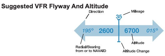
- suggested VFR flyway & altitude
-
image: suggested VFR flyway & altitude
-
- IFR routes
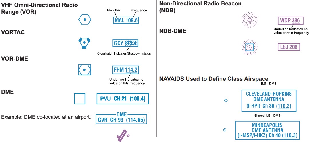
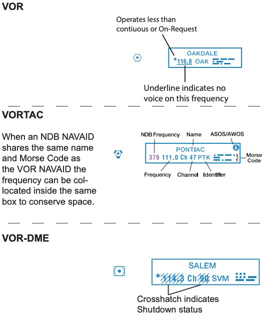
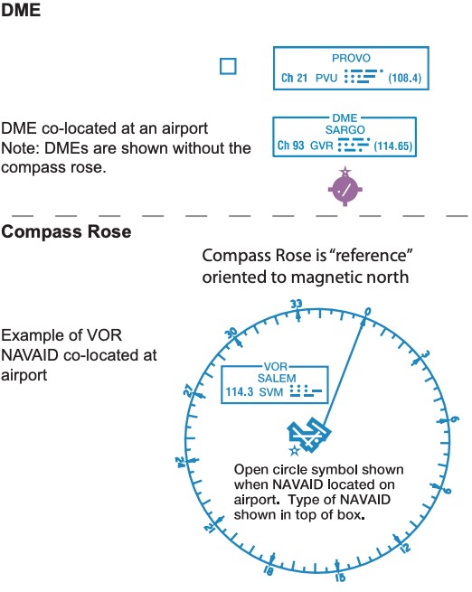
- NAVAIDs:
-
image: NAVAIDs
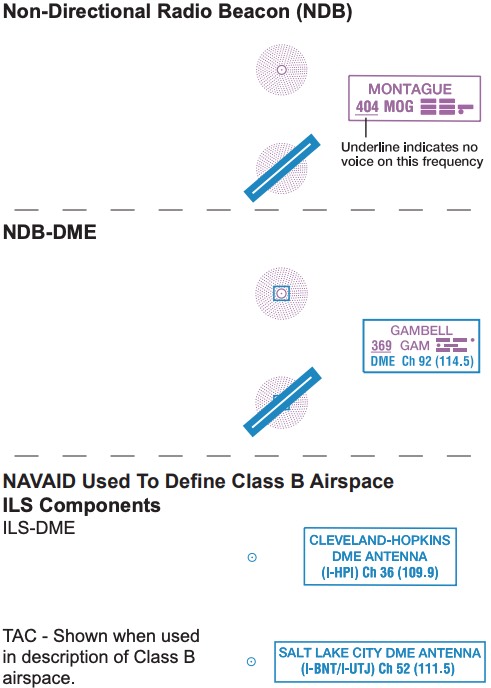
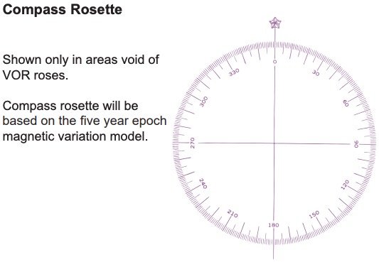
-
image: 122.1R→receive only, you can transmit, but can’t listen from
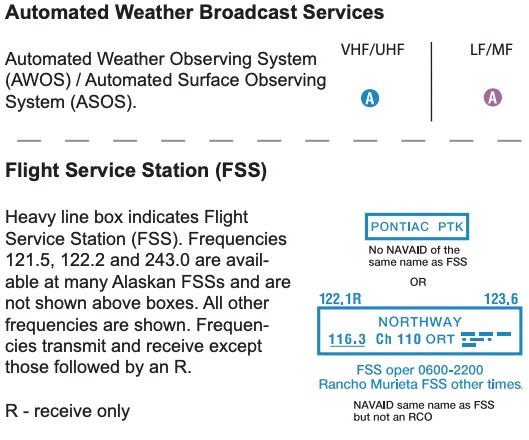
-
image: NAVAIDs
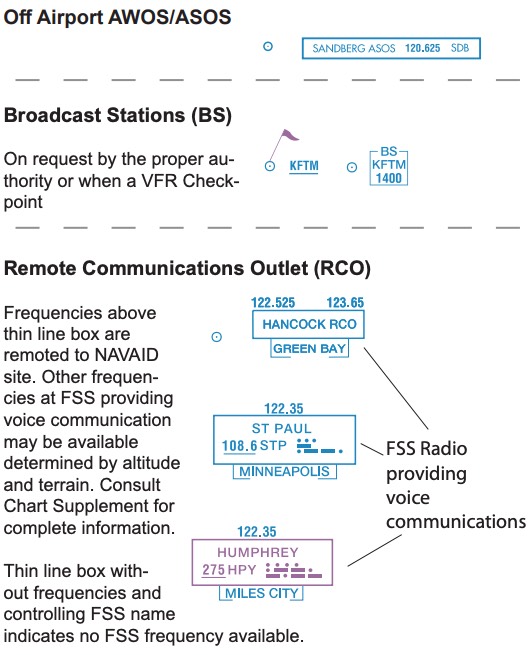
-
- others
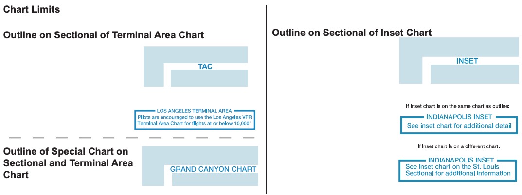
- chart limits
-
image: chart limits
-
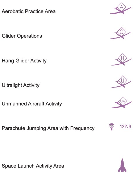
- activities: prachute, aerobatic, glider, etc
-
image: activities
-
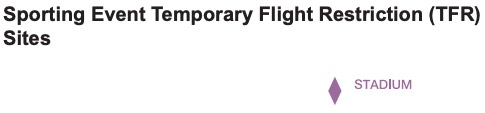
- sporting event TFR: magenta diamond
-
image: sporting event TFR
-
- victor airway: 1200AGL~FL180, 8NM width, class E default
- chart limits
Navigation & XC Planning
- YB NAVLOG: VFR navigation log generator
- my posts
- pilotage: navigation by visual reference to landmarks (checkpoints) on the sectional chart
- dead reckoning: navigation by computing heading/groundspeed/time from known TAS, wind, and course
- route planning: airspace (B/C/D, SUA, TFR), terrain & obstacles (MEF), checkpoints every ~10NM, alternates along the route, glide distance
- altitude selection: VFR cruising altitude (3000AGL↑), terrain/obstacle clearance, winds aloft, glide distance, fuel burn, cloud clearance
- course & heading: TC → (±WCA) → TH → (±variation, east least west best) → MH → (±deviation) → CH
- wind correction: E6B or EFB, wind from right→correct right, headwind→GS↓
- time, speed, distance: time = distance / GS, fuel = time × fuel burn, ETA in local & UTC
- VFR flight plan: file with FSS (1800wxbrief / 1-800-WX-BRIEF), activate after departure (FSS), close at destination, not closed → SAR begins 30 min after ETA
- items: aircraft ID, type/equipment, TAS, departure point & time, altitude, route, destination, ETE, fuel on board (hours), alternate, pilot info, number aboard, color
- flight following: VFR radar advisories (traffic), workload permitting, ask approach/center, squawk assigned code
- transponder codes: 1200 (VFR), 7500 (hijack), 7600 (lost comm), 7700 (emergency)
- lost communication (VFR): squawk 7600, light gun signals from tower, remain VFR, land as soon as practicable
- diversion: decide early, turn toward the alternate first, estimate heading/distance/time/fuel (rule of thumb), then refine, tell ATC/FSS, update flight plan
- lost procedures (5C): climb, communicate (121.5 or ATC), confess, comply, conserve (fuel)
- interception (AIM 5-6-13): follow interceptor’s instructions, rock wings to acknowledge, squawk 7700 (unless told otherwise), try 121.5 / 243.0, don’t make sudden maneuvers
Weather Products
- official primary source
- National Weather Service (NWS): METAR, TAF, ATIS/AWOS/ASOS
- Aviation Weather Center (AWC): GFA(aviationweather.gov)
- FSS: 1-800-WX-BRIEF(1800wxbrief.com)
- FSS (Leidos): pre/post/in-flight service, flight plan, weather, NOTAMs, en-route advisory, search&rescue, contact[122.2 or 1-800-WX-BRIEF (992-7433)]
- briefing type: standard[complete/detailed/when no prior briefing], abbreviated[updates], outlook[6+hrs ahead/less detailed]
- when calling FSS: provide [aircraft ID, pilot info, departure time(UTC), route&destination, VFR/IFR, altitude]
- in-flight: FSS(122.2), FIS-B(ADS-B), NEXRAD, ATC
- FIS-B: transmitted via ADS-B (sentry/stratus), not real-time, 5-15’ delay
- ATIS: airport (wind/vis/cloud/temp/dew/altimeter/NOTAMs), update hourly (55min)
- AWOS: basic (wind/vis/altimeter/temp/dew/DA)
- ASOS: more advanced than AWOS+(precipitation type, intensity, runway condition)
- METAR: routine current weather report (wind/vis/rain/cloud/altimeter), airport, valid current hour, published typically between 45-59 min past the hour, [sky≥5000,vis≥5]?→none, RMK A02 (automated station with precipitation sensor→distinguish snow/rain)
- SPECI: update with METAR, significant change(vis↓, thunderstorms, wind shifts)
- PIREP: real-time by pilots, UA(routine), UUA(urgent, turbulence, icing)
- ex) UA /OV LAX090015 /TM 1500 /FL050 /TP C172 /SK SCT025-TOP030 /WX FV04SM /TA 10 /TB LGT /IC NEG
- TAF: by meteorologists, forecast (wind/vis/rain/cloud), 5SM radius from airport center, every 6hours (4 times a day - 00/06/12/18), 24/30 hrs(long international flight)
- TAF AMD (amended, supersede previous TAF), TAF COR (corrected)
- FM(significant change within 1hr), BECMG (gradual change, usually over ~2hrs, NWS TAFs don’t use BECMG), TEMPO(temporary, probability>50%, lasting≤1hr, period<half), PROB30(30% probability)
- winds aloft (FB): various altitudes, every 6hours (4 times a day - 00/06/12/18), (no wind 1500↓AGL, no temp 2500↓AGL), for [choosing alt, fuel plan, icing, freezing level, lapse rate, temperature inversion, turbulence], “752542”, “9900”(light&variable,5kts↓)
- Convective Outlook (AC): forecasting tool, broad view of t-storm. expectation, available SPC, 8 day outlook (1,2,3,4-8), issuance [day1(5x: 06/13/1630/20/01Z), day2(2x), day3(2x), day4-8(1x)], levels[TSTM, 1-MRGL/2-SLGT/3-ENH/4-MDT/5-HIGH]
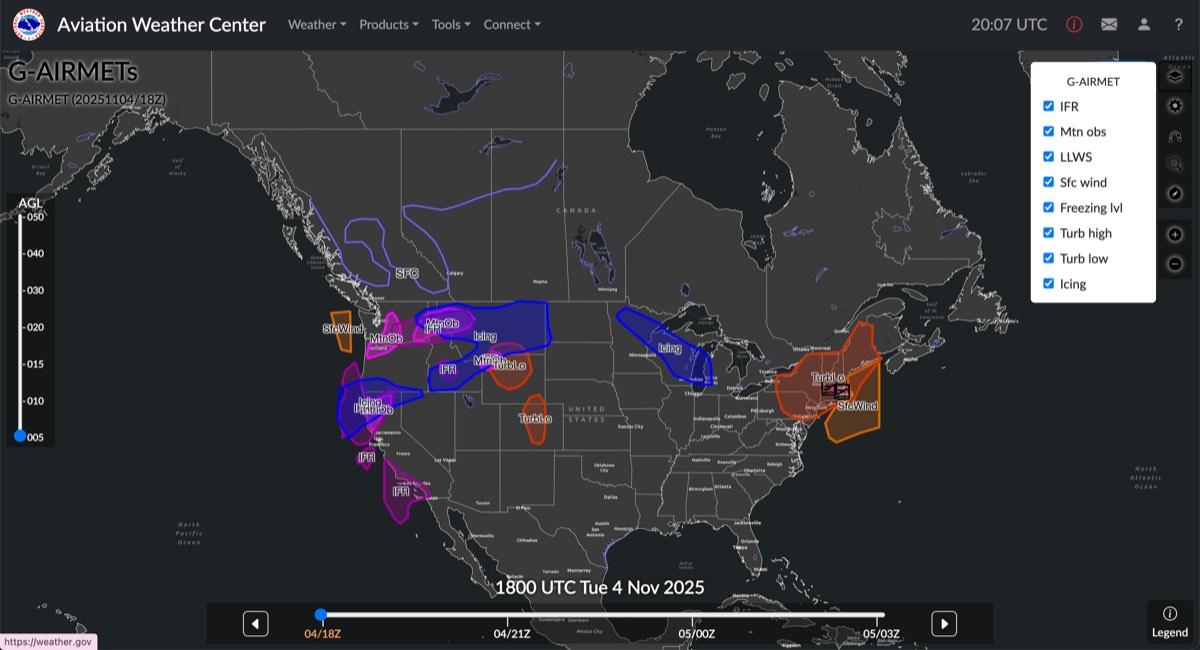
- AIRMET (WA): inflight advisory, hazardous light aircraft, G-AIRMET [issued every 6hr, snapshots every 3hr out to 12hr]
- G-AIRMET: IFR, Mtn obs, LLWS, Sfc wind, Freezing Lvl, Turb High/Low, Icing
-
image: G-AIRMET
-
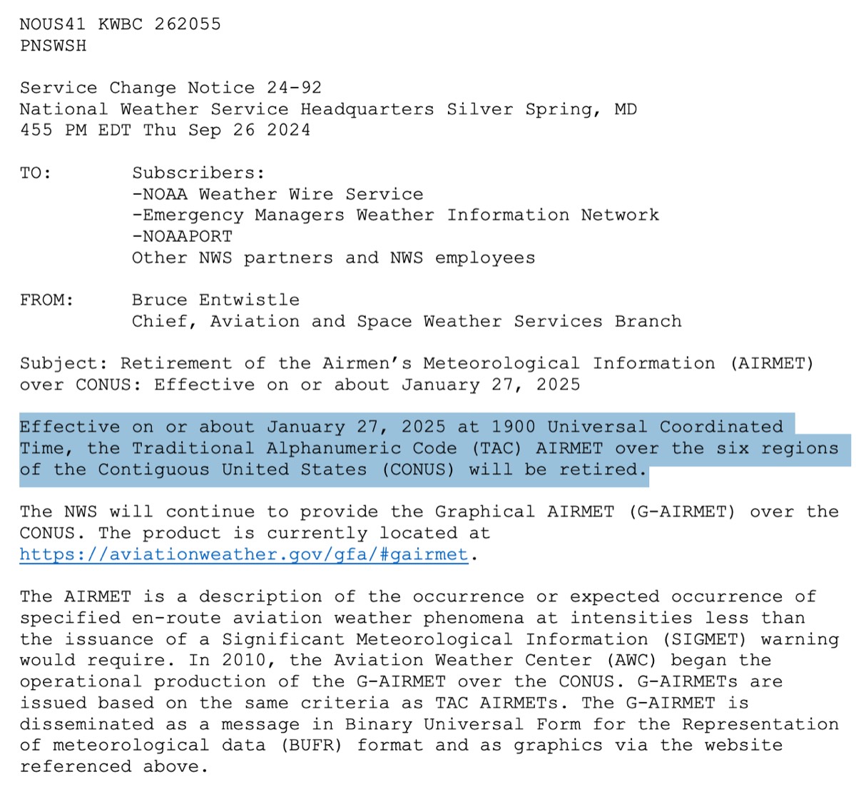
- legacy: issue every 6hrs (starting 02:45UTC), valid 6hrs, [S/T/Z] is no longer used (01/27/2025) → Service Change Notice 24-92
- S(mountain obscuration)
- T(srf wind≥30, turbulence, low-level wind shear)
- Z(icing, freezing level)
- Effective on or about January 27, 2025 at 1900 Universal Coordinated Time, the Traditional Alphanumeric Code (TAC) AIRMET over the six regions of the Contiguous United States (CONUS) will be retired
-
image: legacy
- G-AIRMET: IFR, Mtn obs, LLWS, Sfc wind, Freezing Lvl, Turb High/Low, Icing
- SIGMET (WS): non-scheduled inflight advisory, non-convective severe, for all aircrafts, not associated with thunderstorms, valid 4hrs (6 if hurricane), severe or greater turbulence (CAT), severe icing, volcanic ash, dust/sand storms, anything reducing vis<3sm
- Convective SIGMET (WST): inflight advisory, severe convective weather, hazardous to all aircrafts, hourly at H+55, valid up to 1hr (was 2hrs before 2026.12.01, details)
- convective: vertical movement of air caused by heating → t-storms&lightning
- issued for: (not for Alaska/Hawaii)
- t-storm: areas ≥ 40% of 3000sq miles, strong radar returns, sig. lightning
- severe t-storm: surface wind≥50kts, hail at surface ≥ 3/4 inch in diameter
- embedded t-storm: obscured by cloud layers
- squall line t-storm: at least [60 miles long & affecting at 40% of its length]
- surface analysis chart: snapshot of current weather, on the ground, every 3hrs, provides[H/L, fronts, isobars, weather symbols (rain/fog), temperature, dewpoint, wind]+valid time
- prognostic chart: forecast of future weather, 6/12/24/48 hrs ahead, 4 times daily, provides[H/L, fronts, isobars, weather hazards (turb/icing/precipitation)]
- flight category: LIFR,IFR,MVFR,VFR: vis[1,3,5], ceiling[500,1000,3000]
- VFR[5↑/3000↑], IFR[3↓/1000↓], determined by lower of [vis/ceiling]
| Category | Visibility (SM) | Ceiling (AGL) |
|---|---|---|
| VFR | > 5 miles | > 3,000 ft |
| MVFR | 3-5 miles | 1,000-3,000 ft |
| IFR | 1-3 miles | 500-1,000 ft |
| LIFR | < 1 mile | < 500 ft |
- notes
- magnetic wind[ATIS/ASOS/AWOS] ← in-flight
- true wind[METAR/TAF/WindsAloft(FD)] ← written-weather “what you read is true”
- cloud AGL[METAR/TAF/ATIS/ASOS/AWOS], except PIREP→MSL
- other AGL[WS]
- other MSL[AIRMET/SIGMET/Freezing-Level]
- only [BKN/OVC] are ceilings, [SKC/CLR/FEW/SCT] are not
- SKC(human observation) vs CLR(automated station, 12000AGL↓)
- SLP(temperature corrected, more precise, meteorologist) vs Altimeter(no temperature correction, pilots)
- low clouds(OVC007) & -RA & WSHFT → weather front
- radars: actual precipitation (not cloud), wind pattern
- WSR-88D(NEXRAD/Doppler): ground-based radars, not real-time (5-20min delay), detects [t-storms, precipitation (heavy rain), wind speed, atmospheric motion], mode[clear-air(10min sweep, precise) / precipitation(4-6min sweep, vertical scan↑)]
- TDWR (terminal doppler weather radar): only major airport, wind shear, gusty fronts, heavy precipitation
- ASR (airport surveillance radar): traffic separation is main job, but give weather info
- airborne: aircraft’s radar equipment, better at spotting t-storms than preciptation
Meteorology
a. Atmospheric composition and stability
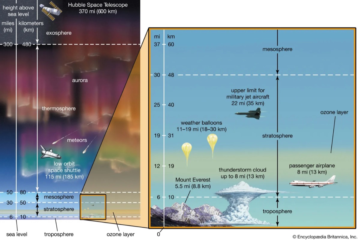
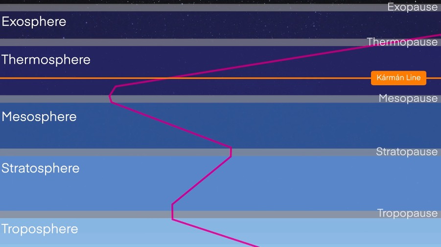
- atmosphere: [nitrogen78/oxygen21/argon0.9/water-vapor0-4]%, troposphere[0-10km/weather/convective-activity/alt↑→temp↓], stratosphere[10-50km/ozone/airlines/alt↑→temp↑], tropopause
-
image
-
image: atmosphere
-
- tropopause: about 36000ft but level varies (↓at poles,↑ at equator), abrupt change in temperature & lapse rate, below tropopause?→standard temperature/pressue lapse rate remains the same(2℃↓/1”Hg per 1000ft)
- stability: determined by [moisture/temperature/lapse-rate], warm/humid→unstable, cold/dry→stable, heating→stability↓, cooling→stability↑
- stable air: resists vertical motion, stratiform, smooth air, steady precipitation, fair-poor vis
- unstable air: promotes vertical motion, towering(cumuliform), rough air, showery precipitation, t-storms., good vis
b. Wind (e.g., windshear, mountain wave, factors affecting wind, etc.)
- wind: change in pressure→horizontal movement of air→wind
- isobar: millibars, connect points equal pressure, closer→pressure gradient↑→wind↑
- factors affecting wind: pressure diff [diff↑→wind↑]
- coriolis force: earth’s rotation(counter clock-wise, left-to-right, west-to-east), deflect wind/air right Northern Hem., poles↑equator:0
-
image: coriolis force

-
- friction btwn air/surface: slows down wind→coriolis force↓→wind flow across isobars at slight angle toward low pressure (surface wind slower & turb. than winds aloft)
- gravity: vertical air movements (downbursts/microbursts)
- coriolis force: earth’s rotation(counter clock-wise, left-to-right, west-to-east), deflect wind/air right Northern Hem., poles↑equator:0
- circulation: day[hot land→pressure↓ & cool sea→pressure↑] → wind[sea→land], night[cool land→pressure↑ & warm sea→pressure↓] → wind[land→sea]
- temp inversion: temp↑ as alt↑, hot-day&cool-night→ ground cools → still hot above → warm air lid → trapping cooler air → vis↓(smog/haze)&low-level wind shear
- wind shear: sudden change wind speed/direction in small area
- sudden drastic change in IAS, affect lift & control, low-level WS (less time to recover)
- mainly occurs: t-storms, frontal boundary (cold front), temperature inversion, CAT at high, microbursts
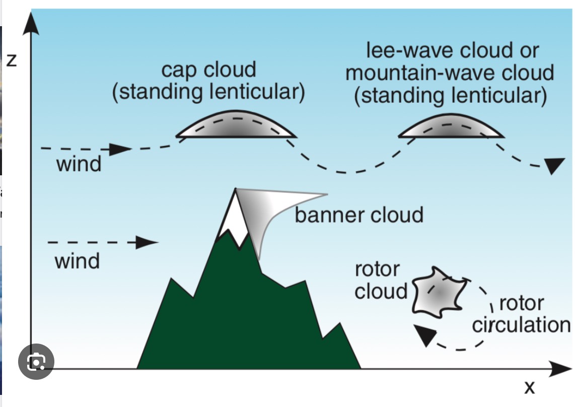
- mountain wave: when 15kts↑ & 30° to ridge, upwind(smooth), but crest-to-downwind?→↑downdraft(hundreds miles)→severe turb, lenticular/rotor cl, approach ridge?→45°(to avoid in case of severe downdraft without ↑load-factor)
c. Temperature and heat exchange
- standard day: 15℃ (59℉), 29.92”Hg (1013.2hPa or mb)
- heat exchange: uneven heating→ warm(less dense)↑ & cold(denser)↓ → changes[pressure/temperature/+friction] → air movement → wind&convective current
- adiabatic: temperature change due to rise/sink (without heat exchange with outside)
- cooling: air rise→surrounding pressure↓→expands→internal energy used→temp.↓
- heating: air sink→surrounding pressure↑→compress→energy added parcel→temp.↑
- lapse rate: rate at which temp↓ as alt↑, standard 1000’↑ [2℃/1”Hg]↓,
- steeper(temp↓rapidly as alt↑) → unstable/convective act
- sublimation: solid→gas (without liquid phase), add/remove moisture to air
- evaporation: liquid→vapor, adds moisture
- condensation: vapor→liquid, removes moisture
- vertical motion: caused by [orographic, convective(buoyancy), frontal] → clouds
d. Moisture/precipitation
- relative humidity:
(water in air mass / total water capacity) × 100%, depends on temperature- warm air→hold more water
- temperature↓→relative humidity↑→condensation↑→more visible moisture
- temperature↑→relative humidity↓→condensation↓→less visible moisture
- dew point: temperature at which air becomes saturated → no longer hold water vapor → condensation begins (water vapor → liquid)
- closer temp&dewpoint→humidity↑visible moisture↑(fog/clouds/dew/frost/rain)→ vis↓
- added moisture → dew point↑ (means, condensation can begin at a higher temperature == less cool down is required for condensation)
- dew point below freezing & aircraft surface at or below freezing → frost
- visible moisture + temp ≤0℃ → icing (air temp can’t go below dew point)
- precipitation: form of water that falls from the atmosphere (rain/drizzle/sleet/virga/hail)
- sleet: snow(solid, ice crystals)+freezing rain(rapid structural icing)
- hail: ice pellets produced by strong updrafts in thunderstorms
- freezing rain & ice pellet: rain→ice (rain above, freezing at current altitude → colder below → inversion)
-
image: freezing rain & ice pellet
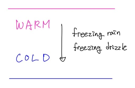
- temperature inversion: above warm layer → cold → snow → [snow→rain] at warm layer → [rain→ice] at cold surface → ice pellets at surface means [freezing rain/supercooled water] at higher altitude
- rain from air 0℃↑ → into air 0℃↓
- rain freezes on impact
- temp could be 0℃↑ at higher alt.
- freezing rain→warm air above, freezing drizzle→often NO warm layer (collision-coalescence)
-
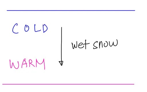
- wet snow: ice→rain (snow above, melting at current altitude), wet snow at your alt.→ temp>freezing → freezing level above
-
image: wet snow
-
e. Weather system formation, including air masses and fronts
- low pressure: air moves[inward/upward/counter-clockwise], generally cloudy&unstable, often rain/snow, rising air cools→moisture condense→[form clouds,icing risk]
- high pressure: air moves[outward/downward/clockwise], typically clear&stable, sinking air warms up→preventing clouds forming
- adiabatic compression: high pressure → air mass sinks → surrounding pressure↑ while sinking → air parcel compress → compression generates heat → temperature↑ → hold more water → relative humidity↓ → less visible moisture
- trough: brown, elongated area of low p., air↑(can’t sink or spread)→cloud forms&precipitation→often bad weather, can bring bad weather even inside high pressure
- ridge: yellow, elongated area of high p., air↓→often good weather
- fronts: boundaries between two air masses (cold front doesn’t necessarily mean that it’s colder than warm front, relative concepts)
- flying across a front? → wind direction & temperature change
- squall line? → (50~200 mile) ahead of a cold front, sudden wind 16~22kts↑
- cold front moves over mountainous? → icing
- frontal waves? → slowly moving cold fronts or stationary fronts
- low level wind shear? → warm front (temperature inversion)
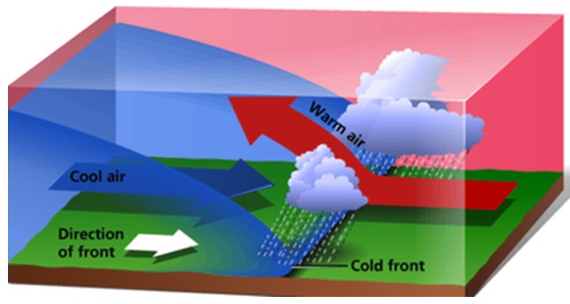
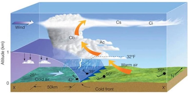
- cold front (blue): [cold/dense/fast-moving/20-30kts or faster] air forces warm air to rise rapidly → steep frontal surface, generally more intense
- hazards: rapid weather change(few hours), towering cumulous(nimbus), strong turbulence, gusty winds, heavy precip, squall line t-storms., hail, tornadoes
- after passage: temperature↓, pressure↑, clearing skies, visibility↑, wind shifts clock wise (because the COLD front brings in relatively denser air with high pressure)
- cold front
-
image: cold front
-
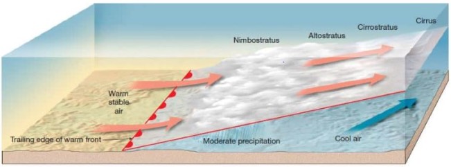
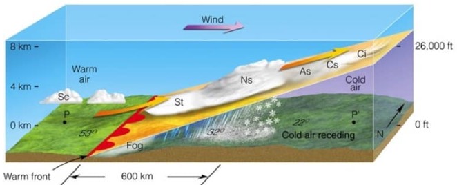
- warm front (red): [warm/less-dense/slow-moving/10-15kts] air glides up over cooler air mass → gradual frontal slope, temperature inversion, generally less intense, produce [wide area of weather/stratiform/ceiling↓/vis↓/rain/drizzle&fog], but summer?→cumulous&thunderstorm possible
- hazards: precipitation fog, freezing rain→icing (warm rain falls into cold air layer and freeze)
- after passage: vis gradually↑ (some haze), temp↑, stratocumulus/showers
- warm front
-
image: warm front
-
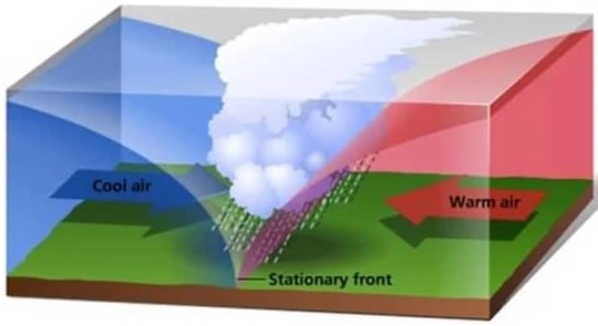
- stationary front (red&blue): two air masses balanced, neither is advancing, can last for days, mixed cold&warm fronts, hazards[low-intensity precip, poor vis, low cloud]
- stationary front
-
image: stationary front
-
- stationary front
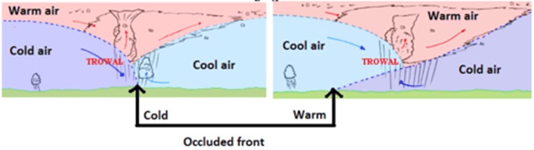
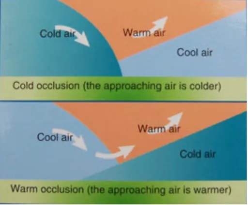
- occluded front (purple): fast-moving cold front catches up slower-moving warm front → lifting warm air mass entirely off the ground, mixed cold&warm fronts
- occluded front
-
image: occluded front
-
- before passage: precipitation & poor visibility
- hazards: strong winds/turbulence/embedded thunderstorms \w thick cloud layers]
- more severe when warm front occlusion (embedded thunderstorms)
- (PHAK) cold front occlusion: fast moving cold front is colder than the air ahead of the slow moving warm front → the cold air replaces the cool air and forces the warm front aloft into the atmosphere
- occluded front
f. Clouds
- clouds: moist air cooled to its dew point → water vapor condenses into tiny liquid
- caused by lifting: convective(air heated&rise),orographic(air rise by mountain),frontal
- hazards: icing (temp. below0℃+clouds), turb(cumuliform clouds), vis↓, t-storms.
cloud base = (temp(℉) − dew point(℉)) / 4.4 × 1000ft- stability of air (before lifting) → cloud [structure/type]
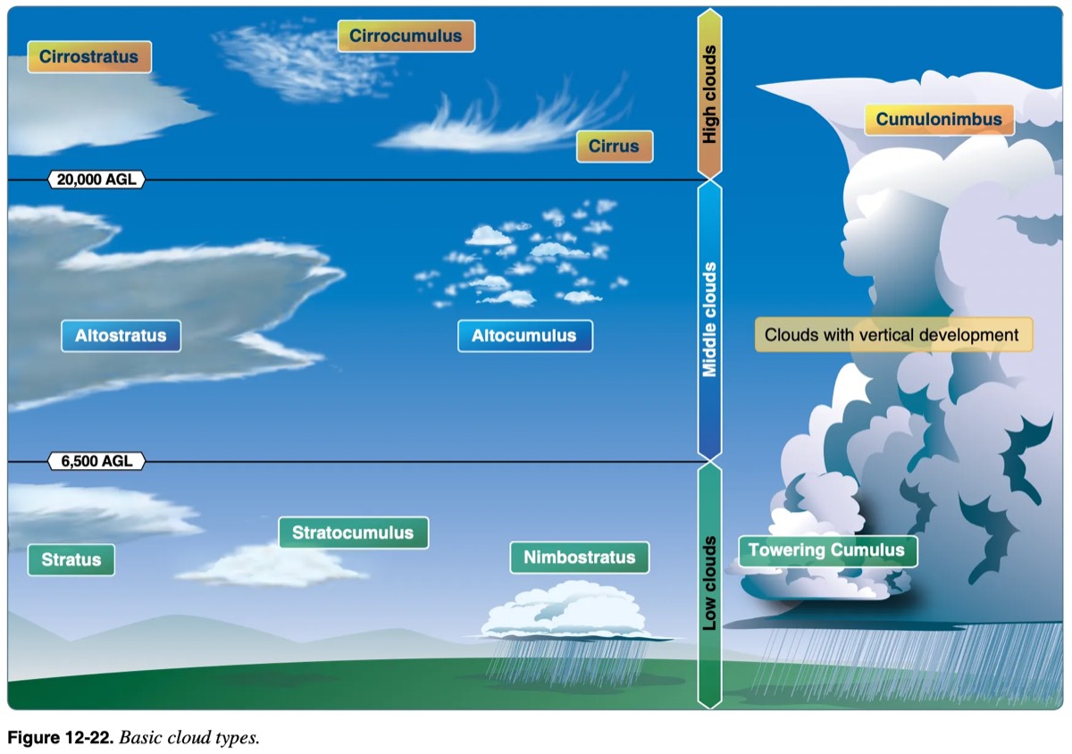
- cloud types: cumulus(piled), stratus(in layers), cirrus(high-level,20000↑,ice-crystals→stay away), nimbus (rain-bearing), alto(middle-level,6500-20000), cumulonimbus(CB)→worst
- height: none→6500, alto→6500~20000, cirro→20000↑(ice-crystals)
- type: nimbus(rain), stratus(straight/stretch), cirrus(see-through), cumulus (accumulated)
-
image: cloud types
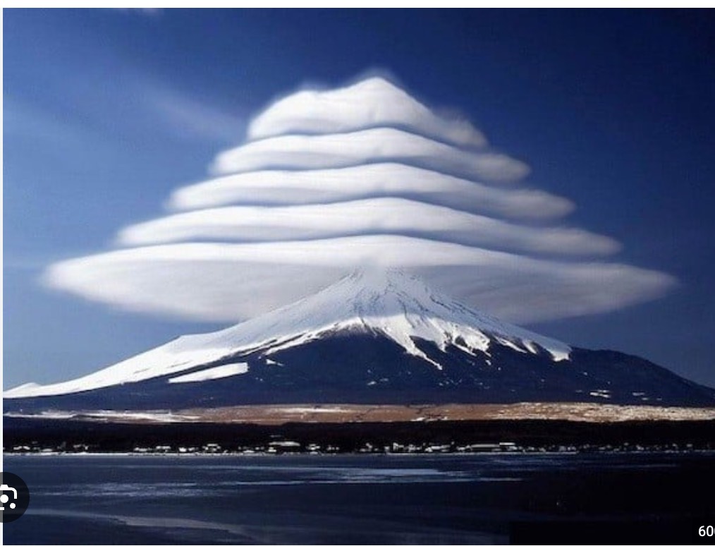
- lenticularus: lens-shaped, formed over mountains in strong winds → heavy turbulance
-
image: lenticularus
-
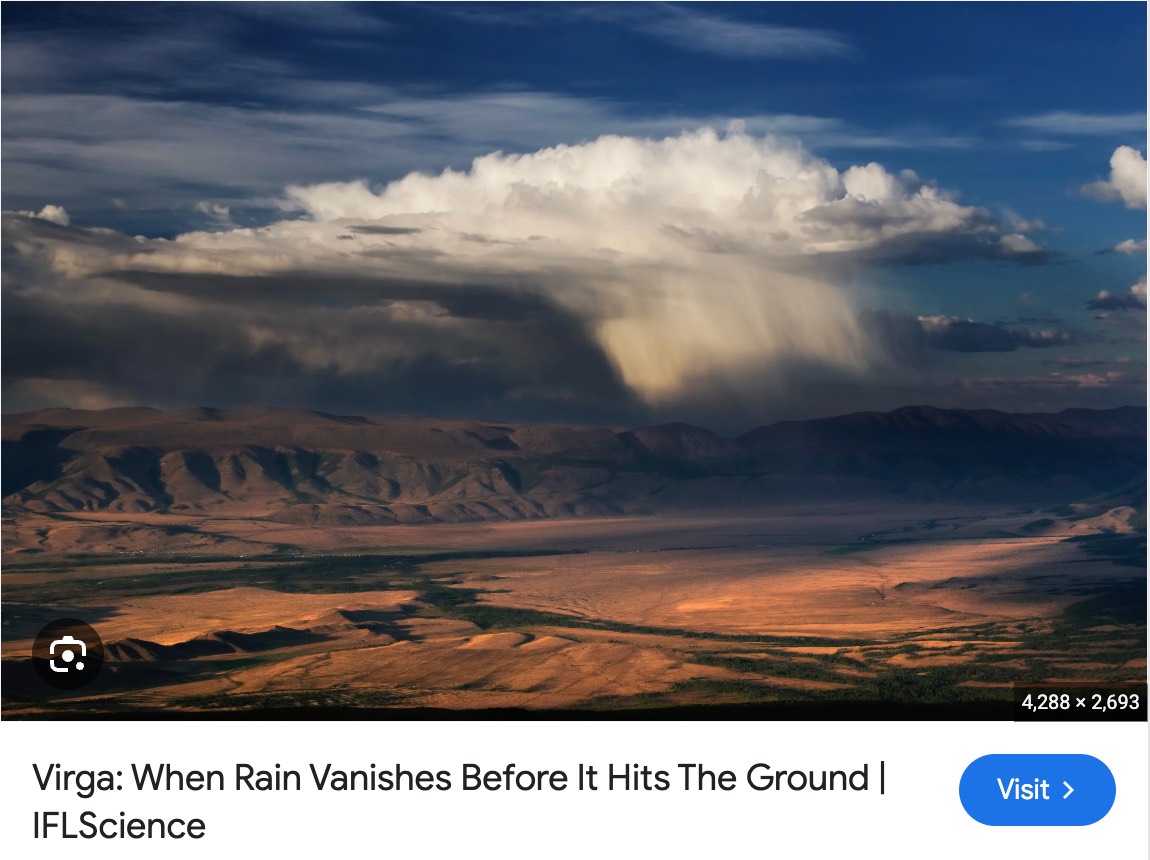
- virga - contains strong downdrafts (rain vanishes before its the ground)
-
image: virga - contains strong downdrafts (rain vanishes before its
-
- rotor clouds
-
image: rotor clouds
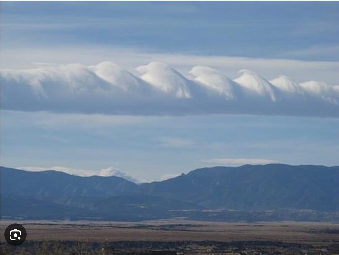
-
g. Turbulence
- turbulence: unsteady/irregular motion of air
- thermal turb: hot days→uneven heating→warm air↑→cumulus clouds & storms
- mechanical turb: wind blowing over [rough gound/mountains]→choppy air
- frontal turb: two air masses(cold front)→warm air↑→instability&bumps
- CAT: invisible in clear sky, often near jet stream (due to strong wind shear)
- turbulence intensity
- light: momentarily changes in [altitude/attitude(+yaw)]
- mod: changes in [IAS/altitude/attitude(+yaw)], but aircraft remains positive control at all times
- severe: large/abrupt changes in [IAS/altitude/attitude(+yaw)], aircraft momentarily out of control
- CAT (clear air turbulence): sudden severe turbulence, cloudless region, violent buffeting, strong WS(60-90kts), typically [found:above 15000AGL(20000-50000’ cloud-free area) or tropopause, caused by: mountain-wave/jet-stream], curved jet-stream /w deep low pressure trough → greatest turbulence, possibly identified through long cirrus clouds, upper trough on polar side of jet stream
- jet stream: wind>50kts, can go up to 240kts, 4-8miles (20000-40000’) in height (near tropopause), winter→temp.diff between polar&equator↑→stronger, [winter/stronger/south]↔[summer/weaker/north]
h. Thunderstorms and microbursts
- thunderstorm: unstable(steep)lapse rate, sufficient moisture(small temp-dewpoint spread), lifting action(surface heat, orographic, frontal)
-
image: PHAK
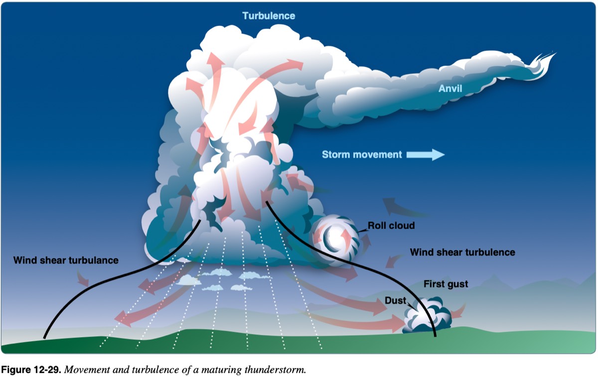
-
- thunderstorm stages: cumulus[cloud-develop/strong-updrafts], mature[most intense/up&down-drafts/rainfall-begins/severe-turb/wind-shear/lighting/hail], dissipating[weakens/mostly-downdrafts/rainfall-decrease/often anvil top]
-
image: PHAK
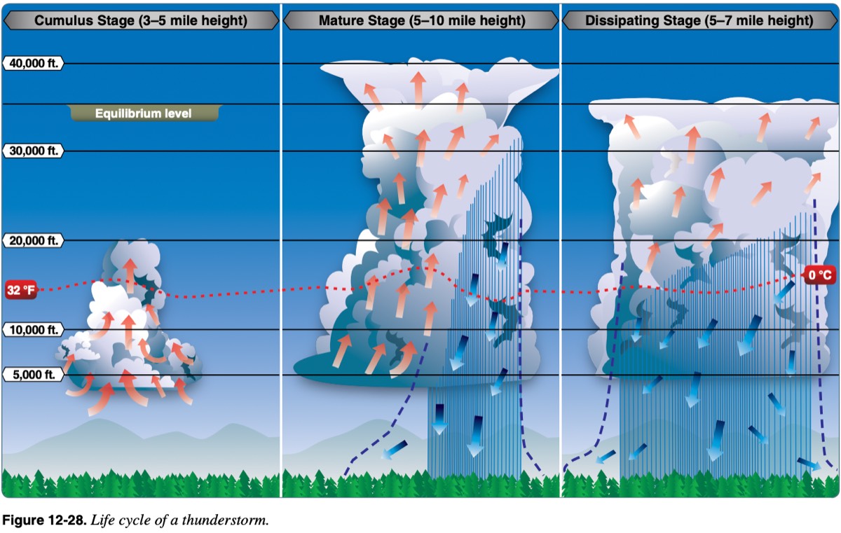
-
- thunderstorm caution: keep 20NM distance (hail/rain can be thrown up to 20NM)
- thunderstorm types
- single cell: short-lived (less than 1 hr), localized rain showers
- supercell: persist several hours, most dangerous, single rotating updraft (up to 9000 fpm), high prob. tornadoes & large hail
- squall line: narrow band, often forms ahead of cold front but nonfrontal, brings most severe weather [destructive winds, heavy hail, tornadoes], wide area, long-lasting
- microburst: [undetectable/small/strong]downdraft → sudden/powerful wind near ground, virga?→microburst below
- form of WS, short-lived (5-15 min), dangerous WS(especially takeoff/landing)
- wind(150mph=131kts, change 30-90kts), losing altitude 6000ft/min, 2.5miles↓ wide
i. Icing and freezing level information
- PA28: defroster, carb heat, pitot heat
- intensity: trace, light, moderate(accumulation 1~3inches/hour), severe
- low-pressure areas: rising air → cool down → visible moisture↑ → icing risk↑
- performance degradation: 1/2 inch ice → lift↓ by 50%
- icing→disrupts airflow(lift↓thrust↓drag↑weight↑)→AoA↑ for lift→ stall speed↑
- approach speed↑, landing distance↑
- mitigate: avoid visible moisture at/below 0℃, encountered?→exit immediately (180° turn, climb/descend to warmer air), pitot heat/carb heat/defroster ON
- hand fly, find cloud base/top, leave visible moisture (climb/descend/turn), warmer temperature, lower humidity
- types: instrument, induction, structural
- instrument icing: forms on instruments & sensors → inaccurate readings → pitot-heat
- induction icing: forms in engine’s air intake system → airflow↓ → disrupts air/fuel mixture → engine performance↓ → engine failure (carb icing)
- carburetor icing: forms when [temperatures (-7~21℃, 70℉) / relative humidity above 80%], due to steep temperature drop in carburetor venturi → carb heat
- structural icing: forms when visible moisture contacts below freezing aircraft surface, forms on exterior surface (wings/tail/props) → change airfoil shape → risk↑
- clear: large droplet spreads. [smooth/clear/hard/dense]→difficult [detect/remove]
- rime: small droplets freeze instantly. [milky(rough&white) color, brittle texture] → easier to spot, forms on thinner parts (wing edges)
- mixed: when [snow/rain] coexists(unstable/mixed clouds), severe perf loss
- +structural icing: “most likely”→freezing rain (“least” likely→high clouds)
- freezing level: lowest altitude temperature 0°C, know it before flight, sources [AWC/winds aloft forecast (FB)/PIREP/weather briefing]
- known icing: PA-28 not certified for flight into known icing → avoid, never take off with [frost/ice/snow] on the airplane
- icing on airfoils: shape change→weight↑lift↓(less noticeable at low AoA)→stall speed↑
- plan&predict (CAFFU): Cloud layers, Air temperature & pressure (more likely in low-pressure areas, cool temperatures), Fronts movement, Freezing level, Use weather briefing (METAR/TAF/AIRMET/SIGMET)
- anti-icing/deicing: anti-icing(prevention), deicing(removal)
- for airfoil: inflatable deicing boots, thermal anti-ice leading edge, weeping wings
- for windshield: alcohol anti-ice, electric heating anti-ice, defroster
- for propeller: alcohol anti-ice, electric heating anti-ice, deicing boots
- others: pitot heat, carb heat
j. Fog/mist
- fog (PAIRUS): cloud near surface(50’), air cools to its dew point & moisture added
- Precipitation: warm rain falls through nearly saturated cold air → moisture evaporates → humidity↑ → [added moisture→dewpoint↑] → air saturated(condensation) → fog. happens [warm front / slow-moving cold front / temperature inversion]
- Advection: warm/moist air moves over cooler surface (coastal areas), opposite of steam fog, forms quickly, cover large areas, wind<15kts (15kts↑?→low stratus cloud)
- Ice: extremely cold (below -25°F), Arctic regions
- Radiation: calm/clear night(valley), ground cools air above, dissipate with sunrise or light wind
- Upslope: wind pushes moist/stable air to upsloping terrain (mountain obscuration)
- Steam: cold/dry air moves over warm water, looks like steam’s rising from the water, common in winter (/w low-level WS & icing)
- fog(FG) vs mist(BR): fog(vis<5/8mile), mist(5/8≤vis<7) is often dissipating form of fog
k. Frost
- surface below freezing, water vapor condenses onto that surface
- effects: even thin layer→significantly disrupt airflow→lift↓drag↑→stall speed↑
- hazards: dangerous especially during takeoff, block [pitot tubes, static port]
- removal: [anti-icing/de-icing] fluid, wipe off, melt in [heated hanger, sun]
l. Obstructions to visibility (e.g., smoke, haze, volcanic ash, etc.)
- Haze (HZ): suspended(floating) fine/dry particles, causes visual illusions→makes runway/terain farther→low approach
- Smoke (FU):widespread low visibility, temperature inversion→worst
- Volcanic Ash (VA): extereme danger, sandblasting→[ruins windshield(scratch), blocks pitot-tubes, melts inside jet turbines(engine failure)], SIGMETs.
- Dust (DU) & Sand (SA): lifted by strong winds, reduces visibility, block engine air filter
Human Factors & ADM
Human Factors
- IMSAFE, PAVE
- *carbon monoxide (CO, mono- means 1), carbon dioxide (CO2, di- means 2)
- hypoxia: oxygen deficiency body cells, 12000↑, hypoxic(altitude), hypemic(anemia/carbon monoxide poisoning→inability to carry oxygen), histotoxic(alcohol/drugs→inability to use oxygen), stagnant(G), [euphoria/dizziness/headache/tunnel-vision], sol[oxygen-mask/pressurization]
- oxygen (unpressurized cabin): above 12.5~14 (crew must use after 30min), above 14 (crew entire time), above 15 (each occupants provided), FAA[10000day/5000night]
- carbon monoxide poisoning: [colorless/odorless] exhaust fumes, prevents red blood cells carrying oxygen, symptom[exhaust-smell/dizziness/headache/blurred-vision], sol[heat-off/vents-open/land ASAPoss]
- hyperventilation: not enough carbon dioxide in blood, excessive breathing, [dizziness/headache/suffocation/muscle-spasms], sol [talk/loud/paperbag]
- hypothermia: body [loses heat > produce heat]
- middle ear & sinus blockage: congestion block pressure equalization climb/descend, symp[ear pain/facial pressure], sol [avoid flying/valsalva/yawn/chew-gums/eat]
- body system
- vestibular: inner ear detects [motion/balance] → [pitch/roll/yaw]
- somatosensory: body nerves in [skin/muscles/joints]
- visual: cones(color¢ral vision, need brighter light), rods(night&peripheral vision)
- spatial disorientaion: ICEFLAGS (FA=visual), visibility↓→spatial disorientation↑, avoid head movement during IMC, trust instruments
- vestibular illusion ICEFLAGS
- inversion: climb→straight → tumbling backward
- coriolis: head, prolonged turn → trick inner ear → feels tilting/accelerating diff dir
- elevator: strong updraft → feels nose-up
- leans: slow bank → feels level-flight → corrected feels like banking opposite
- graveyard spiral: prolonged turns → feels level-flight → corrected feels like turn
- somatogravic: rapid[accel/decel]→feels[nose-up/down], ↑dangerous takeoff
- visual illusion: ICEFLAGS brain misinterprets visual input
- false horizon: visual cues misinterpretation (starts/city-lights→creates false horizon)
- autokinesis: staring at stationary light → appears to move
- optical illusion: light distortion before entering eye → sol[know-airport/weather&PAPI]
- wide/downslope rwy→appears lower→misleading high approach
- narrow/upslope rwy→appears higher→misleading low approach
- why uplslope appears higher? → upslope → see the whole runway clearly → that usually happens when you’re flying high → misleading low approach
- featureless (sparse) terrain(snow/water)→appears higher→misleading low approach
- rain on windshield→appears higher→misleading low approach
- haze/fog→appears far→misleading low approach
- vestibular illusion ICEFLAGS
- dark adaptation: allow 30min full adaptation
- light→dark: cones(quick adapt,sensitivity↓) rods(slower start,sensitivity↑→max 20-25min), cones↑<7min, rods↑>7min
- scanning: seried of short/regularly spaced eye movements, disappearing horizon or ground lights→weather may deteriorating
- motion sickness: symp[nausea/disinezz], sol[air vents/avoid head movement/see further, avoid heavy meals]
- stress & fatigue: acute(short-term), chronic(long-term), sol[don’t fly/sleep/diet]
- dehydration & heat stroke: cause[hot-temperature/wind/low-humidity/caffeine], symp[headaches/fatigue/drowsiness/cramps], FAA[2-4quarts(2L) water per 24hrs]
- drugs: OTC(over-the-counter) also, impairs[alertness/decision-making/reaction-time]
- alcohol: can remain over 16hrs, best wait 12-24hrs, never within 8hrs, no 0.04%↑, no intoxicated passengers, 1beer/1mixed-drink→3hrs
- decompression sickness (DCS): occurs[sudden-loss-cabin-pressure/scuba-diving]
- after diving→fly→alt↑pressure↓→nitrogen(while diving) comes out(bubble)→DCS
- 8000↓[uncontrolled ascent:12hrs, controlled:24hrs], 8000↑ always 24hrs
ADM
- ADM: systematic approach to determine the best action
- statistics: 80% accidents are related to human factors, 24% landing, 23% takeoff, 1/3 of weather related accidents due to poor IFR skills or VFR into IMC
- hazard: present condition, could lead to accident
| hazardous attitude | example | antidote |
|---|---|---|
| anti-authority | don’t tell me what to do! | follow the rules (written in blood) |
| impulsivity | do it quickly! | not so fast, think first! |
| invulnerability | it won’t happen to me | it could happen to me |
| macho | I can do it! | taking chance is foolish |
| resignation | what’s the use? | I can make a difference |
- risk: future impact of an uncontrolled hazard. mitigate[IMSAFE/PAVE/], sterile cockpit[taxi/takeoff/climb/approach/landing], process[identify/assess/analyze/decide/control/monitor], risk↑[scud-running/VFR into IMC]
- decision making process: 5P→Plan[route/fuel/weather/NOTAM], Plane[mechanical/db/automation], Pilot[high-altitue/long-trip/challenging-weather/advanced-avionics/IMSAFE], Passengers[pressure], Programming[automation/avionics/system]
- decision making model: DECIDE[detect/estimate/choose/indentify/do/evaluate], 3P[perceive/process/perform]
- automation: pros[workload↓/new-capabilities/simplifies-flying], cons[complacency], icing→disengage AP
- operational pitfalls: peer pressure, fixed mindset, scud running, get-there-itis, VFR into IMC, getting behind aircraft, inadequate fuel reserves, flying outside envelope, neglecting basic procedures, pleasing passengers, meeting schedules, demonstraing skills
- situational awareness: “know what’s going on, understand how it affects”, developed through[training/discipline/experience], monitor[traffic/weather/ATC], manage workload[frequency/ATIS/monitor/checklist]
- common accident factors: inadequate [pre-flight/planning/control/fuel], CFIT, poor in-flight decision, misjudgement[distance/speed/altitude]
Night Operations
- night vision: rods(night & peripheral vision), cones(color & central vision), night blind spot at center → off-center viewing (5~10° away), scan slowly
- dark adaptation: about 30 min, avoid bright white light (dim red light can impair map colors), oxygen↓ at altitude → night vision↓ (FAA recommends oxygen 5000ft↑ at night)
- night illusions: black-hole approach (dark terrain → feels high → low approach), autokinesis (staring at a single light), false horizon (city lights/stars), featureless terrain
- position lights: red(left wing), green(right wing), white(tail)
- red & green → coming toward you (head-on)
- only red → crossing right to left, only green → crossing left to right
- only white → moving away from you
- night equipment & lights: FLAPS (91.205(c)), position lights sunset to sunrise (91.209), anti-collision lights (if equipped)
- personal equipment: flashlight (white & red, spare batteries), charts with backup, know switch locations by feel
- airport lighting: beacon (white/green civil), PCL (7/5/3 clicks in 5 sec), runway edge (white, instrument rwy → yellow last 2000ft or half rwy, whichever less), taxiway edge (blue), obstruction lights (red/white)
- night taxi: slower, use taxiway lights/signs, landing/taxi lights, beware of other aircraft lights
- night currency (61.57(b)): 3 TOL full stop within 90 days (1hr after sunset to 1hr before sunrise) to carry passengers
- night fuel: VFR-night → +45 min
Number & Formula
- descend plan: 3° glide path → GS5(or GS/210) fpm with 1000ft per 3NM
- distance(NM) = (altitude to lose / 1000) × 3 (or altitude to lose / 300)
- e.g. descend 2500ft → 2.5 × 3 = 7.5NM + safety margin(3NM)
- speed(fpm): GS/210 or (GS5)
- e.g. GS 100 → 100 × 5 = 500fpm, GS 120 → 120 / 2 × 10 = 600fpm
- distance(NM) = (altitude to lose / 1000) × 3 (or altitude to lose / 300)
- Unit
- 1SM = 5280ft
- PA (pressure altitude) = (Standard Pressure − Current Pressure) * 1000 + Indicated Altitude
- Pressure Altitude (PA)
- PA = Altitude (field elevation) + (29.92 - current altimeter setting) x 1000
- in flight → altitude shown with 29.92 set
- Density Altitude (DA)
- DA = PA + [120 x (outside air temp.in degrees Celsius – standard temp.for that altitude)]
- ft/NM, ft/min
- ft/NM given → required ft/min (what to set on the VSI)
- (ft per min) = GS / 60 * (ft per NM)
- ft/min (VSI) & GS given → ft/NM
- (ft per NM) = (ft per min) * 60 / GS
- ft/NM given → required ft/min (what to set on the VSI)
- speed limits: 250 10000↓, 200 under [B, 2500↓, 4nm C,D]
- oxygen: 12.5~14, 14↑, 15↑
- atmosphere: nitrogen78, oxygen21, argon0.9, water vapor0-4, standard(15, 29.92), 1000ft↑ → 1inHg↓2℃↓
- altimeter ±75, VSI 6-9 sec, ±°5 within 5 min
- 29.92 (above FL180)
- Timed compass turns at standard rate: 3° per second
- PA-28-161: Vs0(44), Vs1(51), Vne(160), Vno(126), Va(88-111), Vfe(103), Vy(79), Vx(63), Vg(73), Vb(87), turb(111), final(63)
- LAHSO: min vis≥3SM
- rwy centerline: every 50ft, w-until last 3000ft & last 3000ft (w/r 2000ft, r 1000ft)
- rwy edge: white, instrument rwy → yellow last 2000ft or half rwy (whichever less)
- light: non-towered → radio click (in 5 sec: 7, 5, 3)

