My Instrument Rating Checkride: Oral and Flight Review
Intro
Most of the oral was one long IFR cross-country, and the flight didn’t go as briefed.
- This is a review of my Instrument Rating checkride: the questions the DPE asked and how the flight actually went.
- Most of the oral was built around an IFR cross-country scenario. The DPE opened my ForeFlight briefing and went through it item by item, from NOTAMs to approach charts.
- For a keyword review of the oral topics, see my Instrument Rating Checkride Oral Cheat Sheet. For my PPL checkride, see My Private Pilot Checkride: Oral and Flight Review.
⚠️ Every DPE is different. This is one checkride, one day, one examiner. Always prepare from the Instrument Rating ACS.
1. Oral (General)
- Required documents
- What documents must a pilot carry? (photo ID, pilot certificate, medical certificate)
- Required maintenance?
- Explain AD and STC.
- Required documents for the airplane?
- Minimum equipment required? Where can you find it?
- Qualifications
- What’s the class, issue date, and expiration date of your medical certificate?
- When is an instrument rating required?
- When do you have to file an IFR flight plan?
- Requirements for a PIC to carry passengers?
- Pro rata share.
- Flight review?
- Can an IR checkride substitute for a flight review? (Yes, 61.56(d))
- Requirements to act as PIC under IFR? (6 approaches, holding, intercepting and tracking within the preceding 6 months), grace period
- After that? IPC
- How is an IPC conducted? Where can you find it? (ACS)
- Currency vs proficiency?
- Human factors
- body systems, illusions, night vision, oxygen requirements
- Pitot-static system
- Which instruments use the pitot-static system?
- What happens when the static port is blocked, and what would you do?
- What happens when you use the alternate static source?
2. Oral (Scenario-Based Cross-Country)
- The assignment was something like:
- Plan an IFR cross-country from our airport to a destination less than 300 NM away.
- 1 passenger plus about 30–50 lbs of baggage.
- Departure at 9 AM.
- Use the most current weather and forecasts.
- What resources do you use for the weather briefing?
- How do you make a go/no-go decision?
- Personal minimums. (I explained every little detail.)
2.1 Flight Plan
- How do you file a flight plan in ForeFlight?
- When do you need to file?
- How long will your flight plan stay valid on ATC’s side?
2.2 Route
- Why did you choose this route?
- Difference between T-routes and Victor airways?
- Why are Victor airway minimum altitudes higher than T-route minimums?
- MEA? OROCA? MOCA?
- (Picking a point on the chart along the route) If the engine fails here, how do you know you can reach the nearest airport?
- Key: POH glide performance.
- (Picking a Class C boundary) If your glide distance is 11 NM, can you make it to this Class C airport if the engine fails here?
2.3 Altitude & Fuel
- Why did you choose this cruising altitude?
- Minimum fuel requirement for IFR? (Plus your personal minimum.)
- Note: 91.167: enough fuel to the destination, then to the alternate (if required), then 45 minutes at normal cruise.
2.4 ForeFlight Briefing
The DPE opened my ForeFlight briefing and went through it.
- What is a NOTAM?
- What NOTAMs are there for today’s flight?
- There were 23 NOTAMs that directly affected the flight, such as an unserviceable VOR on the route and a runway closure. I had written a summary of all of them, and the DPE had me explain every single one.
- SIGMET, convective SIGMET, AIRMET (Sierra / Tango / Zulu): what are they, and when are they issued?
- (Surface analysis chart) Explain troughs, high and low pressure, isobars, and fronts.
- METAR reading. (Make sure you can read the RMK section.)
- What do the temperature and dew point tell you?
- PIREP reading (UA routine, UUA urgent).
- TAF reading, even details like TX and TN (forecast max and min temperatures).
- Explain the wind chart.
- Explain the winds aloft table. How can you use it? Calculate the freezing level.
- Icing
- How does icing affect performance?
- Key: stall speed increases.
- How would you land with tailplane icing?
- Key: no-flap landing.
- FIKI (flight into known icing)? Would you?
- Induction icing?
- Carburetor icing temperature? (The DPE wanted the exact number.)
- Note: carburetor icing is possible from about 20°F to 70°F (-7°C to 21°C) with visible moisture or high humidity, and can occur at outside air temperatures up to about 100°F (38°C).
- Structural icing? Types?
- Supercooled large droplets (SLD)?
- What would you do if you saw ice building on the airframe?
- What if ATC doesn’t give you a deviation? (Declare an emergency.)
- If you found frost on the airplane during the preflight, what would you do?
- If you fly without removing it, what happens, performance-wise?
- How does icing affect performance?
- Cloud coverage.
- Minimum distance from a thunderstorm, and why?
- What would you do if you had to pass through an area with thunderstorms forecast?
- Thunderstorm vs microburst?
- Characteristics of a microburst?
2.5 Approach Charts
- What’s the weather at our destination?
- Which runway would you use?
- Open the approach chart for that runway. (It was an RNAV approach.)
Alternate
- What is this symbol? (Non-standard alternate minimums.)
- Where can you find the details?
- (Opening the alternate minimums section) Explain it.
- Does “Category D, 800-2¼” apply to us?
- Why not? (We’re Category A.)
- How do you know? (Approach speed.)
- How is the approach speed determined?
- Key: 1.3 × stall speed in the landing configuration (VSO) at maximum certificated landing weight.
- What should you consider when choosing an alternate?
- When do you need an alternate?
- Can you file an IFR flight plan to an airport without an instrument approach?
- In that case, what do you need? (An alternate with an instrument approach.)
- What are the weather minimums for an alternate without an instrument approach?
- Note: 91.169(c): the ceiling and visibility must allow a descent from the MEA, approach, and landing under basic VFR.
Takeoff Minimums & Departure Procedures
- What is this symbol? (Non-standard takeoff minimums.)
- Does our departure airport have any? What is our takeoff minimum?
- Where can you find the details?
- Does the takeoff minimum apply to us?
- Note: takeoff minimums aren’t mandatory for Part 91 operations, but the obstacle departure procedure and its climb gradient still matter.
- Would you take off with zero visibility?
- Do we have a departure procedure?
- Are you going to use it today?
- Can you follow it?
- Can our airplane meet the required climb gradient?
- How do you know?
- Key: POH climb performance.
- What are the weights for today’s flight?
- Would we perform better or worse than the POH numbers?
Approach
- Which approach will we use today?
- What is LPV?
- Difference between precision and non-precision approaches?
- How are the minimum altitudes different?
- What about the visibility minimums?
- In flight, how do you know we’re flying LPV? (LPV shown on the HSI.)
- How does our airplane indicate it’s flying an LPV approach? (WAAS)
- What are WAAS and SBAS?
- What makes WAAS different from non-WAAS GPS?
- Key: ground reference stations (and geostationary satellites that broadcast the corrections).
- What is GPS? How does it work?
- How does non-WAAS GPS know it’s reliable?
- What is RAIM?
- Minimum number of satellites?
- Note: 4 for a 3D position, 5 for RAIM, 6 for RAIM with fault detection and exclusion (FDE).
- How often does the GPS database have to be updated? (Every 28 days.)
- Difference between LPV, LNAV/VNAV, and LNAV?
- Key: Baro-VNAV.
- While flying an LPV, what would you do if the glideslope fails? (Outside the FAF, and inside the FAF.)
- What is this symbol? (The MSA circle on the chart.)
- What is the MSA?
- What visual references are required to descend below the MDA/DA?
- When are you allowed to descend below 100 ft above the touchdown zone elevation?
- Note: 91.175(c)(3): with only the approach light system in sight, you can descend to 100 ft above TDZE. Below that, the red terminating bars or red side row bars must also be visible, or one of the other required references.
- Any other requirements? (Normal rate of descent, flight visibility.)
- What is this symbol? (VDP)
- What is a VDP?
Holding
- The DPE had me draw an unpublished hold on the chart: “Hold west of the ___ VOR on the 280 radial, 3,500.”
2.6 Lost Communications
- 7600, MEA, AVEF.
- If the clearance limit is a fix where the approach begins, what would you do?
- If the clearance limit is the destination airport and you lose two-way radio halfway, what would you do?
- What would you do after landing?
2.7 Other Questions
- What’s the difference between airports shown in green, blue, and brown?
- Explain weight and balance and CG.
- Fuel, ETE, TAS?
- What is a hot spot (HS)?
3. Flight
3.1 Briefing (the Plan)
The DPE briefed the flight on the ground. It didn’t go as planned.
- Mock clearance and the RWY 14 departure procedure
- ILS/LOC RWY 5 → missed → hold
- VOR/DME-B → missed → no hold
- RNAV RWY 14 → circling
- Partial panel during one of the two non-precision approaches
3.2 Preflight
- I put my backpack in the baggage compartment.
- “Where is the static port?”
- (Pointing at the static wicks) “Do you know what this is?”
3.3 Mock Clearance 1
- The DPE gave me a mock clearance based on my flight plan for the cross-country scenario.
- Then he had me enter the clearance into the GPS. Be ready to load airways and a long clearance route on the GPS.
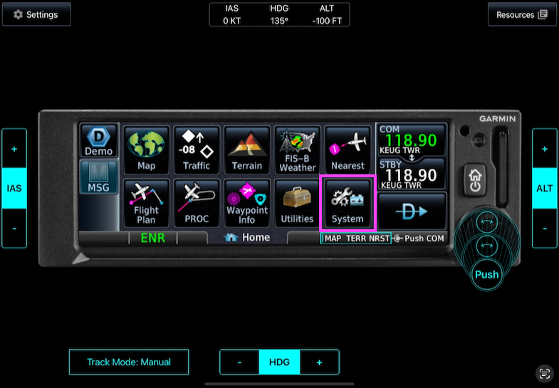
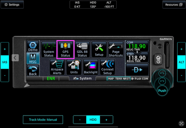
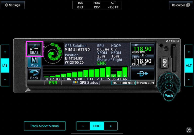
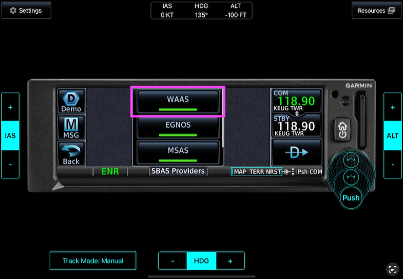
- “How do you know our airplane’s WAAS is enabled?”
- System → GPS Status → SBAS → WAAS
- The DPE gave me time on the ground to brief and set up the first approach.
- “Which runway are we using, and how do we taxi to it?”
3.4 Mock Clearance 2 (Release)
- A mock release from the DPE, something like this:
- Me: “Holding short of runway XX, ready for departure.”
- DPE: “Released for departure. After climbing through 1,500, fly heading 270 when able, then climb and maintain 3,000. Clearance void if not off in 5 minutes. Advise no later than 10 minutes if not off.”
3.5 Takeoff & Mock Departure
- At 400 ft AGL I turned crosswind and climbed to 1,500 ft.
- I almost forgot to contact Departure (mocked by the DPE). I feel I should have done it earlier.
- The DPE kept giving me headings.
3.6 Level at 3,500 ft
- Unusual attitude recovery, 2 times (nose-up and nose-down), both very short.
- Deleted the whole cross-country flight plan from the GPS.
- Moved on to the approaches.
3.7 Approach Plan Change
- Approach told us they were unable to give us the ILS/LOC RWY 5, so we switched to the RNAV RWY 2.
- I couldn’t fully use the briefing and setup I had done on the ground.
3.8 The Approaches We Actually Flew
- RNAV RWY 2 → missed → hold
- entry, inbound leg, outbound turn abeam the fix, leaving the hold
- RNAV RWY 14 → missed → no hold
- The DPE gave me headings (for traffic).
- VOR/DME-B
- Radar vectors from Approach.
- PFD failure 5 NM before the FAF.
- The DPE didn’t let me “go visual” even after passing the MAP. I went visual almost right over the runway, so I couldn’t join the left downwind for RWY 14.
- “Now land the plane.”
- I joined the left crosswind for RWY 14 and landed.
3.9 Other
- The DPE also asked: “What would you do if your iPad or iPhone overheated and caught fire?” (Throw it out.)
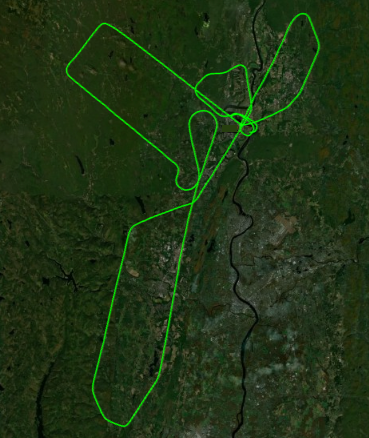
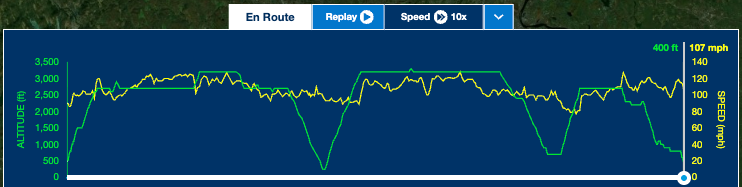
4. Track Log