• Home
  • About
  • Categories
  • Tags
  • NavLog
  • ATC Tool
Subscribe

YB NAVLOG

VFR NAVIGATION LOG

User Guide

For the best experience, please use the desktop Chrome browser.
  • Why I Built This Tool ↗
  • What you'll get: A printable PDF ↗
  • Hate reading instructions? Just hit the SAMPLE button at the top to see how it looks, clear it with the , and fill out the fields as they come up.
  • Data Storage: saved to this browser only, not a permanent or shared store — use export / import to save or load a plan as a file.
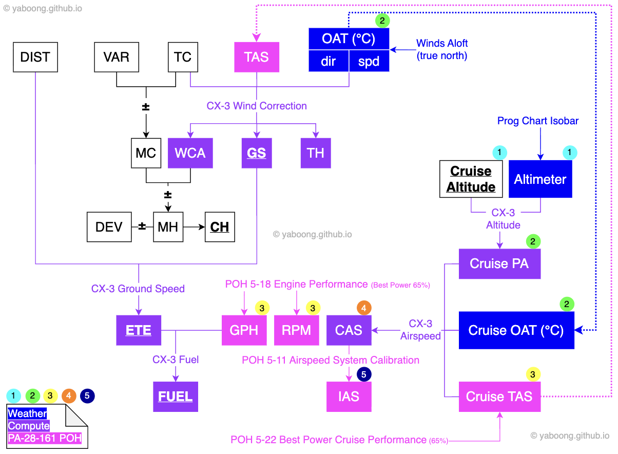
  • Input Order: Enter data in the order shown. Click the in Header to see how the values relate. (colors match the tooltip colors below)
    • Pink = POH
    • Blue = Weather
    • Purple = Compute
  • Tooltips: hover any of these icons (tap on mobile) for a detailed explanation of exactly where to pull that value from.
    • P Check the POH (written against the PA-28-161)
    • W Check the Weather
    • C Compute (CX-3/E6B)
  • Input Guide: every section has a ? button next to its header — click it for a detailed guide on how to use that section.

Resources

POH

  • PA-28-161 (Warrior II) ↗
  • PA-28-181 (Archer III) ↗
  • Cessna 172S ↗
  • Cessna 152 ↗

Route Planning

  • 1800wxbrief ↗
  • ForeFlight ↗
  • SkyVector ↗

Weather

  • AWC (Aviation Weather) ↗
  • NWS (National Weather) ↗
  • SPC (Storm Prediction) ↗

FAA

  • VFR Charts ↗
  • NOTAMs Search ↗
  • Chart Supplements Search ↗
  • Chart Users' Guide ↗

Tools

  • Google Earth ↗
  • CX-3 ↗
  • E6B ↗
  • XC Planner ↗

Meta Data

Cruise Data

Use inHg (27.00–32.00), not hPa/mb

Navigation Data

Distance
—nm
ETE
—
Flight Fuel
—gal
Leg
iVOR
iCRS
iALT
iDist
iMagnetic Course
- True Course ± Variation
MC
iVariation
- VFR Sectional Chart
- Magnetic north ≠ true north
- East Least (-), West Best (+)
Var
iDeviation
- Aircraft's magnetic field
- Compass correction card
Dev
PTrue Airspeed
- Climb: 79 / Descend: 90
- Cruise: POH 5-22 Best Power Cruise Performance (65%, serial nos)
TAS
WWind Direction
- True North is used
- Winds Aloft (ForeFlight)
- Wind/temp data (Aviation Weather)
Wind Dir
WWind Speed
- Winds Aloft (ForeFlight)
- Wind/temp data (Aviation Weather)
Wind Spd
CTrue Course
- Measured on Sectional Chart (True North)
TC
CWind Correction Angle
- Flight computer (CX3/E6B)
- input: TC, TAS, Wind dir/spd
WCA
CGround Speed
- Flight computer (CX3/E6B)
- input: TC, TAS, Wind dir/spd
GS
CMagnetic Heading
- Magnetic Course ± WCA
MH
CCompass Heading
- Magnetic Heading ± Deviation
CH
CEstimated Time of Enroute
- input: GS, Distance
ETE
CFuel Consumption
- input: GPH (gallon per hour), ETE
Fuel

P POH 5-19 Climb Performance
- FPM = average of (Airport PA FPM, Cruise PA FPM)
- Chart is based on MGW
- At checkride weight (~2100 lbs, full tank): add ~+150 fpm

- Realistic Vy climb: 600–700 fpm

*required: Cruise OAT/PA
C CX-3 Climb & Descent
- Input: Dist, GS, RoC/D (Rate of Climb/Descent)
- Output: Desc (=means altitude to climb/descent)
On-course Checkpoint

  • 3–5 NM from Departure
  • POH → FPM
  • CX-3 → On-course Altitude

P POH 5-20 Fuel, Time and Distance to Climb

*required: Cruise OAT/PA, Departure OAT/PA
C CX-3 Climb & Descent
- Input: Desc (Cruise Altitude), GS, RoC/D
- Output: Dist
ToC (Top of Climb)

  • Climb TAS: 79 kts
  • POH → Total dist to cruise altitude
  • CX-3 → Total dist to cruise altitude (crosscheck)
  • TOC Dist = Total Dist - On-course Dist

CDistance: (Alt to Lose / 1000) × 3 NM ToD (Top of Descent)

  • Descend TAS: 90 kts
  • 3° Descent: GS × 5 fpm → 1,000 ft per 3 NM
  • Distance: (Alt to Lose / 1000) × 3 NM
  • Alt to lose: Cruise ALT − TPA

BoD (Bottom of Descent)

  • Target altitude: TPA
  • 3–4 NM from Destination

Nav Log

Press “Generate Nav Log” to build a printable log here.

Fuelgallon

Flight
—gal
—lbs·—
Reserve
—gal
—lbs·—
Total
—gal
—lbs·—
—
—
—
—
—

Weight & Balance

Weight (Lbs)Arm Aft Datum (Inches)Moment (In-Lbs)
PUse aircraft-specific value from the latest maintenance record (NOT sample POH) Basic Empty Weight
Pilot & Front Passenger 80.5 0.00
Passengers (Rear Seats) 118.1 0.00
Baggage 142.8 0.00
C Fuel (48 Gallon Max) 0 95 0.00
Total Loaded Airplane 0.00 — 0.00
P- POH 6-14 C.G. Range and Weight
- POH 2-4 2.13 Center of Gravity Limits
Weight vs CG — Normal / Utility

Takeoff & Landing Performance

Airport DB updated Aug 14, 2026

Elev
ft
W
Altimeter
inHg
C
PA
ft
W
OAT
°C
i
DA
ft
W
Wind Dir
°
W
Wind Spd
kt

Runway
Number

Length
ft

Surface
 
C
Headwind
kt
C
Crosswind
kt
Departure — — — —
Destination — — — —
Alternate — — — —
NavLog field relationship diagram

GitHub RSS
© YABOONG all rights reserved.
Powered by Jekyll. Back to the top